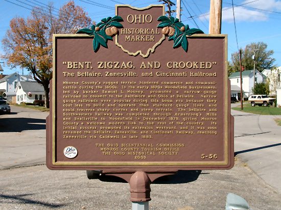
5-56 Bent, Zigzag, and Crooked The Bellaire, Zanesville, and Cincinnati Railroad
Side A: Monroe County’s rugged terrain hindered commerce and communication during the 1800s. In the early 1870s Woodsfield businessmen, led by banker Samuel L. Mooney, promoted a narrow-gauge railroad to connect to the Baltimore and Ohio at Bellaire. Narrow gauge railroads were popular during this boom era because they cost less to build and operate than standard-gauge lines and could traverse sharp curves and steep terrain. The Bellaire and Southwestern Railway was completed through Armstrong’s Mills and Beallsville to Woodsfield in December 1879, giving Monroe County a welcome modern link to the rest of the country. Its initial success prompted its extension westward, and it was soon renamed the Bellaire, Zanesville, and Cincinnati Railway, reaching Zanesville via Caldwell in late 1883.
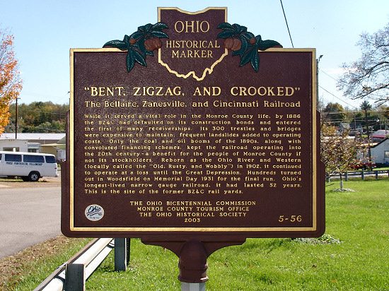
Side B: While it served a vital role in the Monroe County life, by 1886 the BZ&C had defaulted on its construction bonds and entered the first of many receiverships. Its 300 trestles and bridges were expensive to maintain; frequent landslides added to operating costs. Only the coal and oil booms of the 1890s, along with convoluted financing schemes, kept the railroad operating into the 20th century; a benefit for the people of Monroe County if not its stockholders. Reborn as the Ohio River and Western (locally called the “Old, Rusty, and Wobbly” in 1902, it continued to operate at a loss until the Great Depression. Hundreds turned out in Woodsfield on Memorial Day 1931 for the final run. Ohio’s longest-lived narrow gauge railroad, it had lasted 52 years. This is the site of the former BZ&C rail yards.
Sponsors: The Ohio Bicentennial Commission, Monroe County Tourism Office, and the Ohio Historical Society