Comprising 8,000 acres of Brookston-Crosby soils, the marsh is named for Hog Creek which drains it. Once a shallow lake, cranberries, wild flags and grasses flourished here. Reclamation (1868) cost $13.00 per acre. Dredging was done by steam scow; lateral ditches were hand dug by spade. The original grade of 1/3″ in 100′ proved ineffective for onion, beets and potatoes. In 1949 restored drainage outlets breathed new life for today’s soybean and corn agriculture.
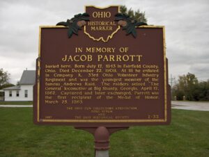
Jacob Parrott who is buried here. Born July 17, 1843 in Fairfield County, Ohio. Died December 22, 1908. At 18 he enlisted in Company K, 33rd Ohio Volunteer Infantry Regiment and was the youngest member of the famous Andrews Raid. The raiders seized “The General” locomotive at Big Shanty, Georgia, April 12, 1862. Captured and later exchanged, Parrott was the first recipient of the Medal of Honor, March 25, 1863.
Intersection of Main Street and Township Road 39 (High Street)
Roundhead
, OH
Upon this site, in the late 18th and early 19th centuries, stood Chief Roundhead’s Wyandot Indian village. This flourishing agricultural community later gave way to white settlement and Hardin County’s first town was laid out here in 1832. Roundhead, or Stiahta, was celebrated for his capture of American General James Winchester during the War of 1812. Roundhead is believed to be buried in this vicinity.
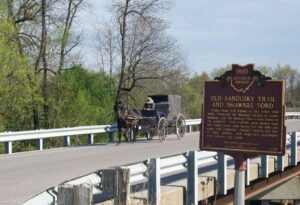
County Road 265 follows an old Indian trail which connected the Wyandot villages at Upper Sandusky with the Shawnee Mac-o-chee towns to the southwest. Many wigwams were pitched near this Scioto River ford during the late 18th and early 19th centuries. Soldiers (during the War of 1812), settlers, and stagecoach passengers later followed this route.
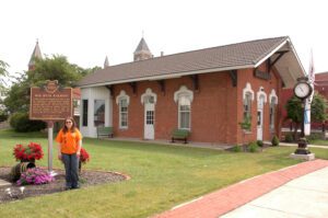
In 1832 a charter was granted by the state of Ohio for construction of a railroad between Sandusky City and Dayton. The right-of-way privileges included Hardin County. The first train, of the Mad River and Lake Erie Railroad, arrived in Kenton from Sandusky on July 14, 1846. The railroad was completed to Dayton in 1851. The depot on this site was erected in 1882.
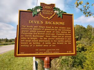
The knolls and ridges found in this vicinity were formed by deposits of gravel left by the retreating glacier which covered much of Ohio during the Pleistocene Era 10,000 years ago. Popularly known as “Devil’s Backbones,” these ridges can be several miles in length. As the glacier retreated it also left large round depressions in the earth’s surface known as kettlers. A kettle was formed by the melting of a buried mass of ice.
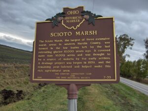
The Scioto Marsh, the largest of three extensive marsh areas in western Hardin County, was formed in the low basins left by the last retreating glacier 10,000 years ago. It covered more than 16,000 acres and was thought to be a source of malaria by the early settlers. A drainage project was begun in 1859, and the remaining peat-ladened soil helped make this rich agricultural area.
Approximately 1000 feet east of this marker lies the graves of sixteen American soldiers from Fort McArthur who gave their lives during the War of 1812. The fort, a one-half acre timber stockade containing huts, was built in the summer of 1812 to guard the Scioto River crossing of Gen. William Hull’s “Trace” to Detroit. Construction of the fort was under the command of a future Ohio governor, Col. Duncan McArthur.