Sounds of boat horns and brawling packet crews resounded for many years at this lock and 142 others on the Ohio and Erie Canal. The canal was a 308-mile water toll road built between 1825 and 1832 from Lake Erie at Cleveland to the Ohio River at Portsmouth. The early growth of Akron and Massillon was due to the canal. Railroads caused its decline and the flood of 1913 destroyed its usefulness.
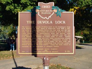
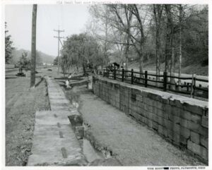
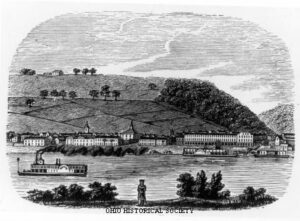
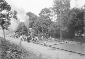
The Devola Lock was one of eleven built on the Muskingum River from Marietta to Ellis, north of Zanesville, from 1836 to 1841. The locks are approximately thirty-five feet wide and 160 feet long. The State of Ohio funded the project as part of the Ohio Canal System. The improvements made the shallow river navigable by steamboats. Travelers ascended over 100 feet from Marietta to Dresden on ninety miles of river. Farmers shipped corn, wheat, eggs, and wool, while manufacturers shipped goods, staples such as sugar, the mail, news, and entertainment. After 1880, competition from railroads caused a gradual decline in the river traffic. Today the locks remain in operation for the enjoyment of pleasure boaters.
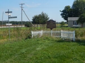
The twelfth lock on the Hocking Canal, the Sheep Pen lock underscores Southeast Ohioans’ efforts to open their region to the world during the mid-nineteenth century. Built as a guard lock, it was intended to permit slackwater navigation of the Hocking River by regulating water depths where river and canal met. Those plans were later abandoned and the mechanism was converted to a lift lock, which raised and lowered boats as required by changes in the canal’s elevation. (Continued on other side)
Ripley was incorporated as the village of Staunton in 1812. Its name was changed in 1816 to honor General Eleazer Wheelock Ripley, a hero of the War of 1812. In the years before railroads, Ripley was a principal Ohio River shipping center. Also important were its extensive boat-building, tobacco, pork, and timber industries. Ripley too was the home of saw and planing mills, iron foundries, and a piano factory. Such varied commerce enabled Ripley to remain vibrant throughout the nineteenth century. Although noted as a port, Ripley is best remembered as an abolitionist stronghold. Many of its citizens, including Rev. John Rankin and John P. Parker, served as conductors on the famed “Underground Railroad.” The notoriety of Ripley’s anti-slavery network perhaps eclipsed that of nearby Cincinnati, earning the town a reputation as the “Black Hole of Abolitionism.” (Continued on side two)
Colonel Ebenezer Zane, one of the founders of Wheeling, laid out the village that became Bridgeport in 1806 on the site of Fort Kirkwood (1789). Originally named Canton, it acquired its present name after the bridge to Wheeling Island was built. The arrival of the National Road in 1818 made the growing town a major portal into the state of Ohio for westbound emigrants, adding to its importance as a port for Ohio River traffic. With the advent of railroads and, later, transcontinental highways, Bridgeport continues to serve as Ohio’s “Gateway to the West.”
On this site, the Miami and Erie Canal, that came north from Cincinnati and the Ohio River, intersected with the Wabash and Erie Canal that came from Fort Wayne and Evansville, Indiana. From this point, which became the town of Junction, the canals proceeded as one to Defiance, Toledo, and Lake Erie. From the 1830s to the 1870s, the canals played a key role in the settling of Paulding County, an area that was once a part of the Great Black Swamp. They held the promise of easier and quicker passenger transportation and commodity shipping and Junction became a landmark for fugitive slaves escaping to Canada. Once a thriving and growing community, the village of Junction became a forgotten historical note with the passing of the canal era and the coming of the railroads. Today, the Buckeye Trail and North County Trail follow the canal path through Paulding County.
David Snively built the Federal-style Pennsylvania House in 1839 along the newly constructed National Road. This tavern and inn was an important stopover for livestock drovers and pioneers traveling by foot, on horseback, or in Conestoga wagons during the westward expansion of the United States in the nineteenth century. Dr. Isaac K. Funk, of Funk & Wagnalls fame, lived in the house in the 1840s while his father served as its tavern keeper. Closed as an inn after the Civil War, it then served as a doctor’s clinic, boarding house, and secondhand shop before falling into total disrepair. The Lagonda Chapter of the Daughters of the American Revolution saved it from demolition and has owned and operated it as a museum since 1941. The Pennsylvania House was put on the National Register of Historic Places in 1972.
Ephraim Root (1762-1825), a wealthy Connecticut lawyer, was one of 57 investors in the Connecticut Land Company and served as its secretary and agent. In 1795, this group purchased three million acres of land in the Western Reserve. Root held interest in 100,000 acres, including Township 2 in Range VIII, which he named Rootstown. In 1800, Root traveled by horseback with his helper Henry Davenport and surveyor Nathaniel Cook to divide the township into 48 sections, reserving Lot 6 for his own use.