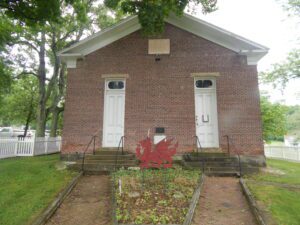
In 1972 a group of Welsh-Americans chartered the Welsh-American Heritage Museum to preserve Welsh history and culture, and to preserve the Welsh Congregational Church. The old brick church was where songs of praises rang, as the Welsh gathered and sang beloved hymns of their homeland in four-part harmony. The church is a link in a long, unbroken chain of memories and still serves the community as a center of Welsh-American activities and a keeper of the community’s heritage. The red dragon and daffodil are symbols of Wales.
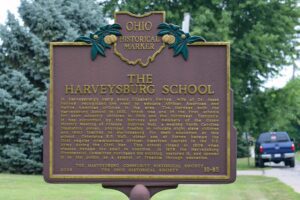
The Quaker village of Harveysburg was founded in 1829 on land originally a part of Colonel Abraham Buford’s Revolutionary War Land Grant. Levi Lukens, a Virginia Quaker, purchased the 1000 – acre survey in 1812 and sold a portion to Rhoden Ham in 1815. Ham then sold a portion of his holdings to William Harvey, a Quaker originally from North Carolina, who developed 47 lots for a village which thrived from its beginnings. Early businesses included grist mills, a tin shop, hardware store, blacksmith shop, a large pork packing plant, a bank, and a dry goods store owned by William Harvey. Its first post office opened in 1839. Harveysburg was incorporated in 1844. The village received its name from a merchant in Cincinnati who told William Harvey that he should add burg to his name and call the place Harveysburg.
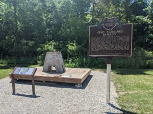
The Ohio Standard Baseline (OSB) was a geodetic baseline that provided highly accurate measurements of the earth and made possible extremely fine calibrations of surveying equipment. Several such baselines were established in Europe and South America during the mid-twentieth century, specifically designed to use a measurement device called the Vaisala Comparator, a precursor of modern laser light measurement systems. In 1953, Dr. T.J. Kukkamaki, then a professor in the Department of Geodetic Science at The Ohio State University, proposed establishing a baseline in Ohio that would be part of the worldwide efforts to accurately understand how the size and shape of the earth change over time. Built between 1965 and 1966, the resulting OSB consisted of a series of eight concrete pillars supporting mirrors and instruments, spaced along a 500 meter distance. (Continued on other side)
The most notable feature of Mantua Center is the “Village Green,” which harkens back to the New England heritage of Mantua Center’s early settlers. The Green sets upon land donated by Hezekiah Nooney Sr. and was important to both the social and commercial interests of the town. The businesses located here were a furniture and cabinet maker’s shop, harness shop, blacksmith shop, post office, tannery, ashery, dry goods store, and distillery. The Methodist Episcopal Church, now the Mantua Civic Center, stands at the southwest corner of the green. Eastlawn cemetery, with a burial that dates to 1816, sits along the south border. The cemetery serves as the final resting place for soldiers of several wars, including the American Revolution, as well as many other early citizens. In 1835 Horace Sizer constructed the stone wall around the cemetery adjacent to Mantua Center Road. [continued on other side]
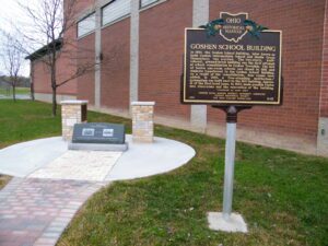
In 1907, the Goshen School Building, later known as both Goshen Intermediate School and Sheila Green Elementary, was erected. The two-story, buff-colored, pressed-brick building was the first attempt at school consolidation in Goshen Township. The last of twelve one-room schools was closed in 1916 and students transferred to the Goshen School Building. As a result of the consolidation, four rooms were added. In 1930, a free-standing auditorium/gymnasium was built next to the 1907 building. Approval of the first bond issue, in 1937, made possible twelve new classrooms and the renovation of the building. (Continued on other side)
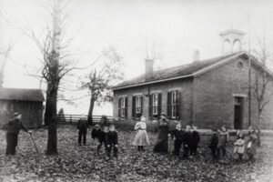
In 1854, Samuel and Rebecca McClellan Collins deeded 1.28 acres to Beavercreek Township, Greene County, for the purpose of building a schoolhouse. The first two schoolhouses were constructed of stone with fireplaces for heat. Collins neighborhood children in first through eighth grade were educated in the present red brick building until 1944, when decreased enrollment forced Xenia Township to close the school. Virgil and Helen Bryson Brantley, great-granddaughter of Samuel and Rebecca Collins, purchased the school property in 1982 and began the restoration of the vandalized and deteriorated schoolhouse. The pony/coal shed and privies were rebuilt on their foundations. (Continued on other side)
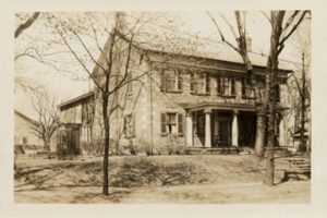
Constructed of sandstone quarried from nearby Putnam Hill, the Stone Academy dates to 1809. The Springfield School House Company erected the building, it is believed, to lure the statehouse from Chillicothe. However, when Zanesville was chosen as the capital the following year, the building was used for public functions and for its “intended” purpose as a school. The Ohio Anti-slavery Society held its state conventions here in 1835 and 1839, with prominent abolitionist leader Theodore Weld, among others, in attendance. The Stone Academy became a private residence after 1839. In the 1870s, it was the childhood home of Elizabeth Robins, the famed late-nineteenth and early-twentieth century actress, playwright, author, and activist. The Stone Academy was donated to the Pioneer and Historical Society of Muskingum County in 1981.
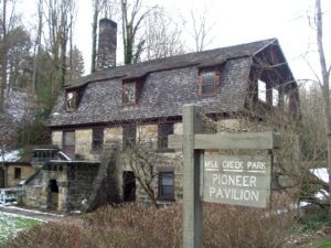
Pioneer Pavilion, one of the oldest structures in Youngstown, is a rare surviving example of early nineteenth-century industry. James Heaton constructed this sandstone building in 1821 as a mill for carding and fulling wool. A millrace from Mill Creek and a waterwheel on the west side supplied the power. In the 1830s and 1840s, the woolen mill was converted to a storage facility for the nearby Mill Creek Furnace and later served as a cattle barn. In 1891, Youngstown attorney Volney Rogers purchased the property for Mill Creek Park, renovating the building in 1893 as a dining and dancing facility, and naming it Pioneer Pavilion. Generations of area residents spanning three centuries have celebrated social events in this historic landmark.