

, OH
In 1798, Judge Samuel Hinckley of Northampton, Massachusetts, drew the 72nd draft in the land lottery held by the Connecticut Land Company and received 15,305 acres in Township 4, Range 1, for which he paid $12,903.23, less than one dollar per acre. The area had been inhabited for many years by trappers, missionaries, and Native Americans. One of the earliest settlers was James McMullen, who acquired the first 160-acre parcel from Hinckley in 1801. Brookfield Township became the crown jewel of Hinckley’s holdings. Hinckley named Brookfield after a city in England and set aside land for the village green and the cemetery stating that they were for public use forever. During the mid-1820s the Overland Stage Line had a run through Brookfield, linking it to Salem, Warren, and Youngstown in Ohio and Erie, Pennsylvania and Dunkirk, New York. (Continued on other side)
, OH
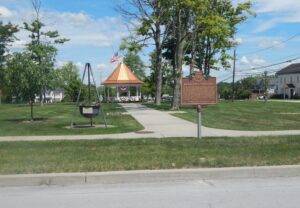
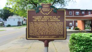
In 1866, Alliance physician, amateur horticulturalist, and politician Dr. Levi Lamborn propagated the scarlet carnation from French seedlings in greenhouses at this site. Opposing William McKinley for the 18th Congressional District in 1876, Lamborn presented the future president with a carnation boutonniere before each debate. McKinley, successful in those debates, continued to use the carnation as a good-luck charm, wearing the carnation in his lapel as president. On September 14, 1901, moments after removing the flower from his lapel and giving it to a young admirer at the Pan American Exposition in Buffalo, New York, President McKinley was killed by an assassin’s bullet. The Ohio General Assembly passed a joint resolution naming the scarlet carnation the state flower on February 3, 1904, as it “represented a token of love and reverence for the Ohio president.” On April 1, 1959, the Ohio Legislature proclaimed Alliance “The Carnation City.”
, OH
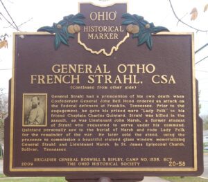
Born in 1832, Otho French Strahl grew up in Malta Township, Morgan County, Ohio. After attending Ohio Wesleyan University and teaching in a schoolhouse that stood on this site, he moved to Tennessee, becoming a successful attorney and landowner. Following the attack on Fort Sumter and President Abraham Lincoln’s call to arms, Strahl chose to stay and fight with his adopted state. Despite his northern roots, he was elected Captain of the Dyers Guards, his local volunteer unit in Tennessee. Two years later, he attained the rank of brigadier general in the Confederate army and served with distinction in some of the bloodiest battles of the Civil War. At the age of 32, Strahl was one of six Confederate generals killed or mortally wounded at the Battle of Franklin. He is buried in Old City Cemetery in Dyersburg, Tennessee. (continued on other side)
, OH
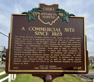
James Willard Converse (1806-1892) opened his store in 1825 at 10 South Chillicothe Road. Serving residents, merchants, and travelers, the store proved central to Aurora’s early commercial development. Converse’s Daybook survives as a glimpse into the habits of early citizens, who, along with household items, regularly purchased whiskey. Surprisingly, such sales surged on George Washington’s February 22 birthday. Converse deeded the business to employee Seth A. Gillett in 1834. Hopson Hurd Sr. (1793-1869) purchased it from Gillett in 1845. Hurd’s store was popular with local farmers who used their home made cheese as legal tender and enjoyed the barrel of whiskey kept in Hurd’s basement for customers who paid their bills. Hurd added a cheese warehouse to his store and, as a major exporter of cheese to Cleveland, Warren, and Pittsburgh, amassed a sizeable fortune.
, OH
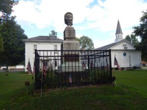
With the outbreak of the Civil War in 1861, many young men of Bristol Township enlisted in the army when President Abraham Lincoln issued his call to defend the Union cause. The death toll of some of these men at the Battle of Shiloh in Tennessee in April 1862 touched the local community as did the loss of Bristol Township lives at the Battle of Perryville in Kentucky, the Battle of Cedar Mountain in Virginia, and other theaters of war later in the year. The local citizenry responded to a plan for a lasting public memorial at the Town Park through a fund raising campaign. In 1863 the town square was transformed with a marble monument placed on an elevated mound at its center. The monument was designed by local artist Frank J. Hammond and manufactured by Myers, Uhl & Company of Cleveland at a cost of $500. [continued on other side]
, OH
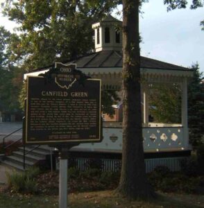
Canfield, named for the area’s primary landowner Judson Canfield, is one of the earliest examples of a New England town plan in both Ohio and the Western Reserve. It dates to April 20, 1798, when surveyor Nathaniel Church arrived from Connecticut to layout the town. Church and his team erected a log cabin and laid out roads and lots using a New England Green Plan that envisioned a communal ground at the center that would later be surrounded by various civil buildings. During the War of 1812, the Canfield Green was used as a drill ground for the Northern Ohio and Western Reserve militia, led by General Elijah Wadsworth. On August 23, 1812, General Wadsworth and the Canfield Dragoons left the Canfield Green heading for Cleveland to defend the United States and the Western Reserve from attacks by the British and their Native American allies. (Continued on other side)
, OH
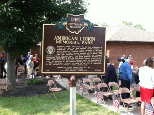
American Legion Union Post No. 79 was organized on August 21, 1919, at the National Guard Armory in Marysville. In 1927, the Legion purchased a 24 acre parcel known as “Clement Woods” to serve as a living memorial “to Union County Veterans of All Wars”. The park was dedicated on August 24, 1927, and renamed American Legion Memorial Park. The brick Memorial Building was constructed from 1937 to 1938 by the Works Progress Administration (WPA). The Post held their first meeting there on September 12, 1938. An addition to the Memorial Building was completed in 1960. In 1989, the Legion donated the park to the City of Marysville on the condition it remains a free, public park.
, OH
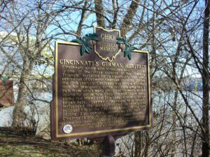
Cincinnati, along with Milwaukee and St. Louis, is one of the three corners of the “German Triangle,” so-called for its historically high concentration of German-American residents. During the 19th century, Cincinnati was both a destination for immigrants to the tri-state area and a hub from which many groups of Germans moved inland to settle new Ohio communities-many along the Miami and Erie canal corridor which began here. German-Americans have greatly influenced the social, cultural, economic and political life of the Cincinnati area. At the turn of the 21st century, approximately half of Cincinnati’s population was of German descent. (Continued on other side)