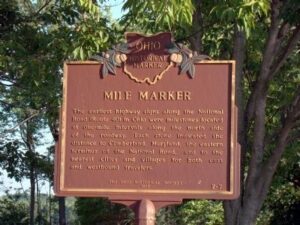
The earliest highway signs along the National Road (Route 40) in Ohio were milestones located at one-mile intervals along the north side of the roadway. Each stone indicated the distance to Cumberland, Maryland, the eastern terminus of the National Road, and to the nearest cities and villages for both east and westbound travelers.
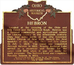
Located at the crossing of the Ohio and Erie Canal and the National Road, Hebron was a favored commercial and agricultural center for Licking County in the nineteenth century. Only four miles north of the city Governor DeWitt Clinton of New York turned the first spadeful of dirt for the Ohio and Erie canal on July 4, 1825. The canal was completed through Hebron in 1828. Nearby Buckeye Lake served as a reservoir and feeder for the canal until 1894 when it was set aside for park purposes. The National Road was completed through Hebron in 1834.
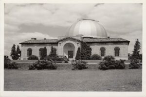
One-half mile east is the site of the former BIG EAR radio telescope. Designed by Dr. John D. Kraus, pioneering radio astronomer at Ohio State University, it had a collecting area of 340 by 70 feet (104 by 21 meters). The observatory was completed in 1963. The Ohio Sky Survey recorded here between 1965 and 1972 was the most accurate, reliable, and complete mapping of cosmic radio signals (the “radio sky”) for many years. BIG EAR gained fame for its ability to detect quasi-stellar radio sources, or “quasars,” and for its discovery of some of the most distant objects known. This observatory conducted a 24-year continuous search for evidence of extraterrestrial intelligence, during which the famous “Wow!” signal was received in 1977. BIG EAR was demolished in 1998. [“Wow!” signal graphic]
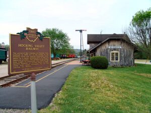
The arrival of the Columbus and Hocking Valley Railroad in 1869 led to the decline of the Hocking Canal and assured Nelsonville’s prominence as a major shipping point of coal and industrial products. The portion of the railway from Logan in Nelsonville was listed on the National Register of Historic Places in 1988, along with steam locomotive #33 and caboose #90704.
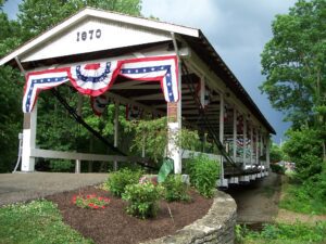
Restored in 1963, the Germantown Covered Bridge on East Center Street, spanning Little Twin Creek, was 93 years old and is reputed to be the only existing covered bridge of its kind in the world. For 41 years this unique inverted bow string truss covered bridge spanned Little Twin Creek on the Dayton Pike in Germantown, Ohio. In 1911 it was removed to its present location where it has been restored and beautified as a link with Ohio’s early history. It is a symbol of individual initiative in America’s early history.
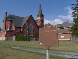
The Cranberry Prairie, southwest of this marker, is a part of Ohio’s natural history. The place was named for the cranberries that grew in a swamp here prior to drainage of the area. The Cranberry Prairie was created by centuries of peat accumulation in a late Ice Age lake that formed at the base of St. John’s Moraine. Paleo-Indian or Early Archaic peoples probably killed the elk whose skeleton was dug up here in 1981. This elk was dated at approximately 7400 B.C. By the 1860s, immigrant German farmers had begun transforming the swamp into fertile farmland. “Wild Bill” Simison, a legendary inhabitant, lived in the swamp and settlers respected him for his knowledge of the area. By the turn of the nineteenth century, Granville Township School #7, St. Francis Catholic Church, and Bertke’s Store stood at the edge of the Cranberry Prairie.