

, OH
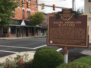
The Ottawa, or “Tawa” Indians had inhabited the Maumee Valley since the middle of the 1700s. By the 1790s, Ottawa settlements included villages along the Blanchard River at the present-day Village of Ottawa. During the War of 1812, Colonel James Findlay destroyed these villages because the Ottawa aided British forces. In 1817, the United States government established a reserve for the Ottawa in exchange for their lands in Northwest Ohio. The reserve encompassed a five-mile square area; its center was the intersection of the Blanchard River and an Indian trace near what is now Old State Route 65. (Continued on other side)
, OH
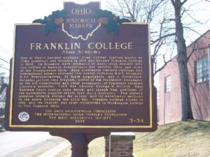
One of Ohio’s earliest colleges, Alma College (earlier known as Alma Academy) was founded in 1818 and became Franklin College in 1825. Its founders were primarily of Scots-Irish descent who had settled in western Pennsylvania and eastern Ohio and were of the Presbyterian faith. Many nineteenth-century national and international leaders attended this school, including 8 U.S. Senators, 9 U.S. Representatives, 32 State Legislators, and 2 Governors. Notables include John Bingham, author of the Fourteenth Amendment to the U.S. Constitution and chief prosecutor of President Abraham Lincoln’s assassins; Civil War General George W. McCook; Ohio Supreme Court Justice John Welch; and Joseph Ray, publisher of the universally popular school text Ray’s Arithmetic. The slavery question bitterly divided the school, and its enrollment declined in the years following the Civil War. Franklin College closed in 1921, and its charter was later transferred to Muskingum College in New Concord, Ohio.
, OH
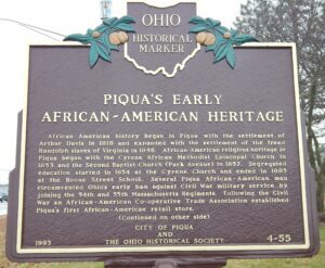
African-American history began in Piqua with the settlement of Arthur Davis in 1818 and expanded with the settlement of the freed Randolph slaves of Virginia in 1846. African-American religious heritage in Piqua began with the Cyrene African Methodist Episcopal Church in 1853 and the Second Baptist Church (Park Avenue) in 1857. Segregated education started in 1854 at the Cyrene Church and ended in 1885 at the Boone Street School. Several Piqua African-American men circumvented Ohio’s early ban against Civil War military service by joining the 54th and 55th Massachusetts Regiments. Following the Civil War an African-American Co-operative Trade Association established Piqua’s first African-American retail store. Continued on/from other side)
, OH
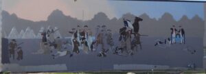
Native Americans inhabited and used much of the land in the Ohio valley as hunting grounds. As American settlers pushed west, conflicts resulted and attempts at peaceful settlement failed. Under political pressure, President George Washington resolved to subdue Indian resistance to American expansion in the Ohio country and appointed General Arthur St. Clair to lead the expedition. St. Clair’s troops camped on the Wabash River (just east of the Ohio-Indiana state line) after an exhausting two-month trek. The ill-prepared soldiers were no match for the forces of Miami, Shawnee, and Delaware Indians who attacked them at dawn of November 4, 1791. By the day’s end, warriors led by Little Turtle and Blue Jacket had killed or wounded nearly three-quarters of the American force-the worst-ever defeat of the U.S. Army by Native Americans in a single battle.
, OH
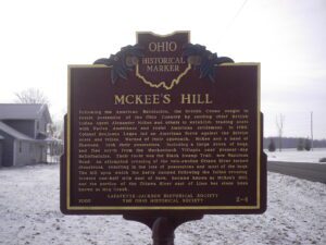
Following the American Revolution, the British Crown sought to retain possession of the Ohio Country by sending chief British Indian Agent Alexander McKee and others to establish trading posts with Native Americans and resist American settlement. In 1786, Colonel Benjamin Logan led an American force against the British posts and tribes. Warned of their approach, McKee and a band of Shawnee, took their possessions, including a large drove of hogs, and fled north from the Mackachack Villages near present-day Bellefontaine. Their route was the Black Swamp Trail, now Napoleon Road. An attempted crossing of the rain-swollen Ottawa River turned disastrous, resulting in the loss of possessions and most of the hogs. The hill upon which the party camped following the failed crossing, located one half mile east of here, became known as McKee’s Hill, and the portion of the Ottawa River east of Lima has since been known as Hog Creek.
, OH
With the signing of the Treaty of Paris in 1783, England lost the American Revolution and ceded to its former colonies land from the Atlantic Ocean to the Mississippi River. By this time, pioneer settlers had reached the eastern bank of the Ohio River, but the Ohio Country, located west and north of the river, was still considered Indian Territory. The Indian tribes desperately defended their hold on this land. On August 20, 1794, United States forces led by Major General Anthony Wayne defeated an Indian alliance at the Battle of Fallen Timbers fought near modern-day Toledo. One year later, on August 3, 1795, the largest assemblage of northwestern Indian representatives at a peace settlement signed the Treaty of Greene Ville, which effectively ceded all land south of the Greene Ville Treaty line to the Americans. The Fort Laurens site was a reference point in the Treaty line. The Ohio Country was then rapidly settled, and in 1808, Tuscarawas County was organized.
, OH
Frederick Rice was born on September 29, 1753, near Bethlehem, Northampton County, Pennsylvania and moved to Westmoreland County, Pennsylvania around 1766. During the American Revolution he served under George Washington at Valley Forge and fought in the Battle of Trenton on December 26, 1776, in which American forces surprised and captured 1,000 Hessian mercenaries. He served for two more years as a spy working against Native American tribes in western Pennsylvania. After his service he married Catherine Lauffer, and they raised eleven children to adulthood. Rice chose this 320-acre site, transferred to him in a deed signed by President James Monroe on May 21, 1821, because it offered excellent springs. He assigned the west half to son Simon and the east half to son Barnhart in 1822. Ownership remained in the Rice family until acquired for the Ohio Agricultural Experiment Station in 1891, renamed the Ohio Agricultural Research and Development Center in 1965.
, OH
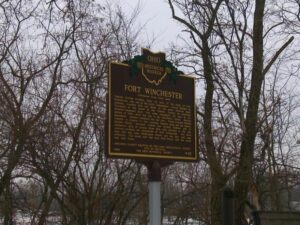
General William Henry Harrison ordered the construction of Fort Winchester at the beginning of October 1812 and it was completed October 15. The fort served as a forward observation post and supply depot for the American army during the War of 1812. Until Fort Meigs was completed in 1813, Fort Winchester was the front line against the British and their Indian allies. During the siege of Fort Meigs, Fort Winchester was a rendezvous point for the troops of General Green Clay and those of Colonel William Dudley. Fort Winchester outlined the shape of a parallelogram, measuring 600 by 300 feet in size. Blockhouses anchored the four corners of the fort and within its stockade were storehouses and a hospital.