

, OH
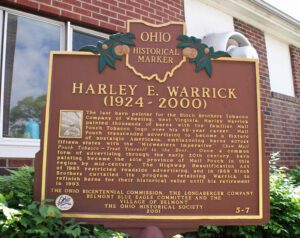
The last barn painter for the Bloch Brothers Tobacco Company of Wheeling, West Virginia, Harley Warrick painted thousands of barns with the familiar Mail Pouch Tobacco logo over his 48-year career. Mail Pouch transcended advertising to become a fixture of nostalgic Americana, emblazoning barns across fifteen states with the “Midwestern imperative”: Chew Mail Pouch Tobacco-Treat Yourself to the Best. Once a common form of advertising through the early 20th century, barn painting became the sole province of Mail Pouch in this region by mid-century. The Highway Beautification Act of 1965 restricted roadside advertising, and in 1969 Bloch Brothers curtailed its program, retaining Warrick to refinish barns for their historical value until his retirement in 1993.
, OH
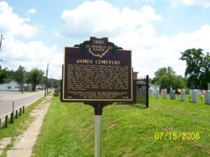
Major John James (1772-1854) established James Cemetery in 1828 on and around a Native American mound that is the only significant ancient mound remaining in the city of Jackson. The mound is about 70 feet in diameter and nearly six feet tall. In the late 1800s, this mound comprised one point of three ancient mound groups forming a triangular configuration along East Broadway Street, formerly known as James Street. One group was a few hundred feet northeast of here on the Watson farm and a second was just to the northwest on the Warnicke farm. These mounds were built by the Hopewell Culture, prominent in southern Ohio from about 100 BC to 400 AD. Major James, his wife, and several immediate family members are buried on the mound including Jackson County pioneers Andrew Long, Daniel Hoffman, and David Mitchell.
, OH
The completion of the Miami and Erie Canal passing through Napoleon in 1843 provided a way to receive manufactured goods, export farm products, and power local mills. The early industries of Napoleon utilized the canal as a source of reliable water power, which led to the development of a mid-19th-century industrial waterfront. Some of the local businesses that relied on the canal were Sayger’s Saw-mill (1843), John Ritter Flouring Mill (1850), Augustin Pilliod’s Napoleon Flouring Mill (1853), and the Napoleon Woolen Mill (1863). These mills used flumes, or artificial channels, to divert canal water to their water wheels. These brick-arch flumes were instrumental in bringing Napoleon into the national economy.
, OH
By the mid 1830s, Ohio had developed a canal system that linked Lake Erie in the north to the Ohio River in the south. Despite the success of the canals, transportation companies searched for other methods to traverse the state. They found their answer in the railroad industry, which proved to be much faster, cheaper, and more reliable than canals. Located on Lake Erie, Sandusky, Ohio was a major trading depot in the area. Plans were made to connect Sandusky to Cincinnati’s port on the Ohio River. On September 4, 1835, construction began in Sandusky on the Mad River and Lake Erie Railroad line, forming the first railroad line located entirely in Ohio. The railroad reached Tiffin by 1841 and Springfield by 1848, where it merged with the Little Miami Railroad line, connecting Lake Erie to the Ohio River.

, OH
Due to what is known as the Sharon Conglomerate or pebbly sandstone, these ledges have played an important role in the daily life of local residents and the economy. The porousness of this rock, which underlies much of Geauga County, supplies most of the county’s drinking water. Thompson Ledges also provided building stone with stone cutters working in quarries turning out doorsteps, watering troughs, gateposts, culverts, and bridges from mid-1800 to 1911 for use in Thompson, Geauga County and occasionally beyond. After 1900, cement became the preferred building material, but still used silica pebbles from the Ledges for gravel and cement. The Ledges have an unusual ecosystem containing several distinctive forests. A chestnut oak forest is pervasive on the top while a northern hemlock forest exists in the exposed creaks and crevices of the upper rim and ledges.
, OH
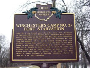
Camp No. 3 was located about six miles below Fort Winchester on the north side of the Maumee River. Militiamen from Kentucky, part of the forces led by War of 1812 Brig. Gen. James Winchester, occupied the camp from November 1812 until December 30, 1812. They had marched off to war in summer wearing their linen clothing; unaware they would end up in the heart of the Black Swamp in mid-winter. The suffering they endured was intense. Camp No. 3, thought to cover an area of about 40 acres, had picketed walls and an earthen bastion at each corner. The soldiers built small huts for shelter. In his diary, Pvt. Elias Darnell of Lewis’ Regiment of Kentucky volunteers referred to Camp No. 3 as “Fort Starvation.”
, OH
In 1942 Cedar Bog became the first nature preserve in Ohio purchased with state funds. Efforts to set this wetland aside began in the 1920s through the efforts of Florence Murdock and her daughter. Efforts intensified in the mid 1930s with help from Walter Brigham Evens, Jr., and finally came to fruition in 1941 due to the interests of Champaign County Common Pleas Judge Owens, Governor John Bicker, and Dr. Edward S. Thomas of the Ohio Historical Society. This relatively small parcel is an outstanding example of a prairie/fen complex known as Cedar Swamp that once covered 7,000 acres of the Mad River Valley. Approximately one quarter of the plant species in Ohio are found here. Cedar Bog also has a large number of rare species, two of which, the Small Yellow Lady’s Slipper Orchid and Prairie Valerian, occur in Ohio only at Cedar Bog or one other site.
, OH
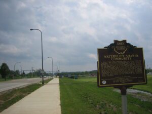
A Shaker village called Watervliet, Ohio, was located here from 1806-1900. The Shakers, originally called the United Society of Believers in Christ’s Second Appearing, were followers of Mother Ann Lee who came from Manchester, England in 1774 and established the first Shaker community in Watervliet, New York. The tenets of the religion included communal living, celibacy, and public confession of sins. The frenzied dance movements, which were part of the worship of their sect, gave the members the name “Shakers.” Attracted by the great Kentucky revivals in the late 1700s and early 1800s, Eastern Shaker missionaries came west to find converts and establish communities. A discontented Presbyterian congregation in the Beaver Creek area called Beulah was the nucleus for the Watervliet Shaker community. (continued on other side)