

, OH
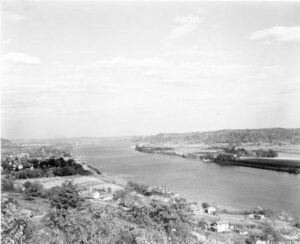
The Ohio River, the southeast border of Gallia County, played a significant role in the development of Gallipolis and Gallia County. One of the state’s first thoroughfares, this waterway enabled pioneers to settle in what was known as the Northwest Territory. On October 17, 1790, approximately 500 French immigrants arrived in Gallipolis, traveling by flatboats from Pittsburgh, and settled in log cabins in what is now City Park, in the heart of Gallipolis. This established the second oldest permanent settlement in the territory. The settlers relied on the River for communication, commerce, and transportation, and the River brought postal service to Gallipolis in 1794. As local business and river trade developed in the 1800s, Gallipolis became a thriving port. The scenic Ohio River is an important inland waterway, providing transportation for many commodities between major cities. The River also provides recreational opportunities for both visitors and residents, including water sports, fishing, and boating.
, OH
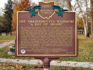
The Moravian Church in America began missionary work among the Delaware and Mohican tribes of North America in the mid-18th century. David Zeisberger, one of the best-known Moravian missionaries, came to the Ohio country with Delaware converts from a mission in western Pennsylvania and founded Schoenbrunn in the Tuscarawas Valley on May 3, 1772. Josua, a Mohican convert and missionary leader, led Mohican and Munsee Christians downriver and settled Gnadenhutten (“Tents of Grace”) on October 9, 1772. Zeisberger served as lead missionary at both villages. By 1775, there was an estimated 200 inhabitants in the village. The British, along with Wyandot and Delaware allies, suspected the Christian Indians of aiding the Americans. To ensure their allegiance to the British, the inhabitants of Gnadenhutten were forcibly removed in 1781 and taken to Captives’ Town on the Sandusky River.
, OH
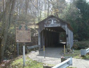
The Teegarden-Centennial Covered Bridge, constructed primarily of white oak is of Multiple King Post design spanning 67 feet. It was built nearly 100 years after the birth of the nation. Located on Eagleton Road, just off Teegarden Road, it is still at its original location, spanning the Middle Fork of the Little Beaver Creek in Eagleton’s Glen Park. It remained in use until 1992 when it was bypassed by a new concrete structure. The official contract for the construction of the bridge was awarded to Jeremiah C. Mountz in June of 1875. The stonework for the abutments was awarded to David Reese and painting of the original structure to George W. Akin in 1876. Members of Highland Christian Church came here to be baptized by immersion. There were over 250 covered bridges in Columbiana County, including at least 16 railroad covered bridges. The Teegarden-Centennial Covered Bridge is one of only five still remaining.
, OH
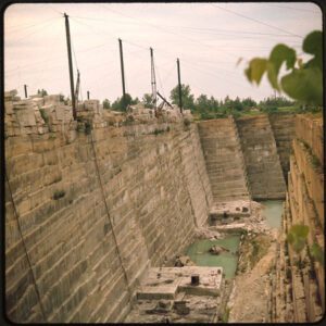
For more than ninety years, this area was the heart and soul of Berea’s sandstone quarries. In the early 1830s, John Baldwin discovered that the area’s sandstone deposits made superb grindstones and building stones. In the 1840s, thriving sandstone quarries developed and became Berea’s lifeblood. Searching for the “American Dream,” German, Irish, Italian, Hungarian, and Polish immigrants, among others, came here to work. The quarries eventually encompassed nearly 250 acres and consumed the fashionable houses of Berea’s “South Side” and the buildings of Baldwin University. The Cuyahoga County Court House, Ohio’s Capitol, and Canada’s parliament buildings are among many structures in North America and Europe constructed of Berea sandstone. Decreasing demand for sandstone and the Great Depression closed the last of Berea’s quarries in the mid-1930s.
, OH
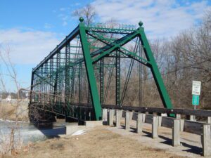
The Bridgeport Iron Bridge, often called the Streng Road Iron Bridge, was built in 1914. It replaced a wooden covered bridge built in 1869 by Reuben L. Partridge (1823-1900) and Isaac J. Grummons (1828-1921), which was damaged by the flood of 1913. The 200′ steel superstructure uses a pin-connected Pratt Through truss design and was constructed by the Central Concrete & Construction Company, Canton, Ohio, at a cost of $8,987. The original substructure abutments were constructed by John A. Maugans (1861-1933) for $3,248, but have since been replaced. In 1992 and 1993, the bridge was renovated under the leadership of County Engineer Steve A. Stolte and Assistant Engineer Jeff Stauch.
, OH
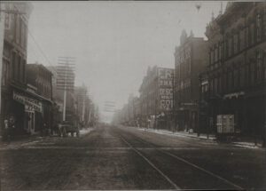
The center of African-American culture in Akron during the mid-20th century, Howard Street was home to many of the city’s black-owned business and entertainment establishments, and provided an atmosphere in which minority-owned businesses could thrive. Attracted to the vitality of the neighborhood, entrepreneur George Mathews (1887-1982) established a barbershop here in 1920 and in 1925 opened the adjoining Mathews Hotel. The hotel quickly became the anchor of the Howard Street district. Mathews’ success allowed him to endow a scholarship fund at the University of Akron in 1964.
, OH
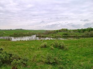
Near this location stood the settlement of African American families known as “The Lett Settlement.” The Lett Settlement was a self-sustaining community of mixed race families, including the Caliman, Guy, and Lett families. The families had formed ties through marriage and common background during the mid-1700s in Virginia and Maryland. These early African American pioneer families came to Ohio as “free people of color,” and began acquiring land in Meigs Township, Muskingum County, and surrounding townships in adjacent counties during the 1820s. They were soon joined by the Brown, Clifford, Earley, Simpson, Tate, and Pointer families. The families of the Lett Settlement were land owners and tax payers in Ohio before the Civil War and challenged the State of Ohio for the right to vote and for access to education during the 1840s, 1850s, and 1860s. (Continued on other side)
, OH
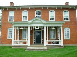
Known as the “Halfway House,” the Gooding House and Tavern was built by George B. Gooding halfway between the towns of Worthington and Delaware in 1827. Its location was influenced by construction of the Columbus and Sandusky Turnpike that was chartered by the State of Ohio the year before. Also known as the “Mud Pike,” the turnpike was slow and difficult for travelers and could take nearly a day to travel 10 miles. The Gooding House was the perfect place for stagecoach drivers to change teams of horses and for travelers to rest and have refreshments. George Gooding also prospered as a farmer with over 1,000 acres of land. This stately brick farmstead remained in the Gooding family for 175 years with each succeeding generation adding its imprint on the property. The Gooding House and Tavern was listed on the National Register of Historic Places in 2005 and restored in 2007.