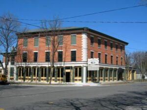
Levi Beebe built in 1836 this structure then known as the Commercial Building housing stores, bank, and post office. During the canal era, the building was a stagecoach stop and social center for Maumee, the Lucas County seat until 1853. Later the inn was called the Neely House, Schiely House, the Bismark, Seurin Hotel Langley Inn, and, after 1940, The Old Plantation.
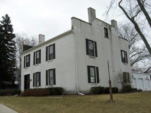
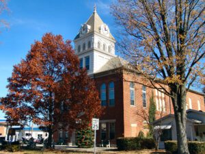
Old Wood County Jail 1847-1870. Built in 1847, during the Presidency of Polk, when Perrysburg was the County Seat, and used as the Jail and Infirmary until 1870. Continued to serve as the Perrysburg Jail until 1899, sold by the town in 1918. Acquired and restored by Mr. and Mrs. Charles W. Hoffmann in 1954. Listed in the Historic American Building Survey and National Register of Historical Landmarks, Library of Congress.
The West Liberty area, in the Mad River Valley, was the location of at least seven Shawnee Indian villages. This elevated site was the location of one of those villages. Several septs or divisions of the Shawnee nation lived in this area after being forced from their homes in southern Ohio. In 1786, together with Simon Kenton, Colonel Benjamin Logan’s army destroyed all the Shawnee villages in retaliation for the Indian raids in southern Ohio and Kentucky. Consequently, the remaining Shawnees moved to northwest Ohio near the present-day site of Maumee.
House of the Lord, Joseph Smith Jr. called this building in his dedicatory prayer March 27, 1836. The solemn, massive weather stained structure stands today as a memorial to Smith’s followers who sacrificed their worldly goods to build of local materials this impressive Gothic Revival and Classic style temple.
Conceived by leaders of the automobile industry to encourage the building of “good roads,” the Lincoln Highway was established in 1913 as the first transcontinental automobile route in the United States. It traversed twelve states and 3,389 miles from New York to San Francisco. The first route across Ohio connected Van Wert, Delphos, Lima, Ada, Upper Sandusky, Bucyrus, Galion, Mansfield, Ashland, Wooster, Massillon, Canton, Minerva, Lisbon, and East Liverpool. By the 1930s much of the original route had become part of the Federal Highway System and U.S. Route 30–many miles of which have, in turn, been bypassed by modern four-lane highways.
The Richwood Opera House and Town Hall was erected in 1890 as a community center designed to house the town council chambers, fire department, jail and opera house. The Richardsonian Romanesque styled building served Richwood in all these capacities for nearly 75 years. The Opera House was the site of minstrel shows, concerts, movies, lecture courses, revivals, farmers’ institutes, commencements, and community meetings. The second floor gymnasium was used for a men’s independent basketball league, dance classes, and as a teen center after World War II. Construction of an interurban railway running between Richwood and the resort town of Magnetic Springs in 1906 provided an expanded audience for the Opera House. (continued on other side)
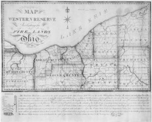
On July 4, 1796, Moses Cleaveland and his survey party landed at the mouth of Conneaut Creek on the southern shore of Lake Erie in what is today Conneaut, Ohio. The Connecticut Land Company, a private land speculation enterprise, had hired General Cleaveland as its agent to survey the Connecticut Western Reserve lands and to found a settlement along the Cuyahoga River, later named Cleveland. Group members pitched tents and erected a crude shelter to protect the provisions and survey equipment before celebrating the independence of the new country with toasts and salutes. The next day they organized into field groups to begin the historic survey of measuring the townships and ranges of the Western Reserve.
Monroe County’s ground-water resources are valuable assets for its people and economy. Especially notable are the substantial quantities of water that can be obtained in the medium sand and gravel underground aquifers located on the eastern side of the county. The Sardis Town Pump, which taps into one of these aquifers, has been in continuous operation since the nineteenth century and has played an important role in the daily life of Sardis residents. At approximately 78 feet deep, it was originally operated with a hand pump and converted to electricity in 1951. It is the drinking choice for many in the community and throughout Monroe County. It is the last of four known public wells that have served the village of Sardis.