

, OH
In the early part of the twentieth century, most small villages in Ohio focused community pride on the accomplishments of their high school’s athletic teams. The Bellpoint basketball teams of the 1920s were a great example. In 1922-1925, the Bellpoint Buccaneers participated in the Ohio State Invitational Tournament to determine the state basketball champion. In 1922, they participated, and then, in 1923 the team lost by a single point to Plattsburg. The Bellpoint teams of 1924 and 1925 were victorious, earning the title of the State Basketball Champions. It was a much slower game in those days with a “center jump” after each score and forty points scored was quite a feat. The Bellpoint High School no longer stands but the accomplishments of these “Cinderella” teams remain an important source of pride for the Bellpoint community. These events are an integral part of the history of Delaware County.
, OH
Many early settlers of Morgan County were of Scot-Irish heritage and brought the Presbyterian faith with them. From this group Reverend John Hunt and twelve charter members organized the first congregation in McConnelsville and Malta in 1824 and third oldest congregation in Morgan County. The congregation built a brick church in 1832 at a cost of $2,361. Known for its excellent acoustics and fine music, the building received the first pump organ in the two villages in 1849. In 1916 the church was stuccoed and added a Sunday school and vestibule. The original bell was sold to the steamboat H.D. Munson in 1865, and the present bell came from the Bristol Presbyterian Church. Because of its large seating capacity, the church was also used for civic functions, including an early court trial. Over the years, members have included General Robert McConnell, founder of McConnelsville, Henry Dawes, uncle of Vice-President Charles Dawes, and Frances Dana Gage, early women’s rights leader.
, OH
The history of Belpre and the Ohio River are inextricably linked. Settlers from New England, including farmers and Revolutionary War veterans, arrived via flatboats at “Belle-Prairie” (beautiful prairie) in 1789. Lewis and Clark’s Corps of Discovery paid a visit in keelboats in 1803 as they began their epic journey to the Pacific. Belpre’s farmers raised fruits, vegetables, and grain. Packet boats carried flour, livestock, vinegar, and passengers down river, some all the way to New Orleans and thence throughout the world. (Continued on other side)
, OH
For over 200 years, the Mentor Lagoons have had a major impact on northeastern Ohio and its people. Located on the site of a large estuary where the Grand River once flowed into Lake Erie, the area evolved into a large marsh. It was here in 1797 that Charles Parker, a member of Moses Cleaveland’s survey party, platted lands for the Connecticut Land Company and established the “Marsh Settlement,” the first in what later became Lake County. Throughout the twentieth century, attempts were made to commercially develop this natural treasure, the most recent occurring in 1996. The proposed destruction of the Mentor Lagoons’ pristine lakefront, upland forest and riverine marsh prompted Mentor voters to call for its preservation. For the first time in Ohio’s history, voters affirmed eminent domain action to protect open space. This led to the city’s acquisition of the 450-acre tract, now known as the Mentor Lagoons Nature Preserve & Marina.
, OH
Known as the “Halfway House,” the Gooding House and Tavern was built by George B. Gooding halfway between the towns of Worthington and Delaware in 1827. Its location was influenced by construction of the Columbus and Sandusky Turnpike that was chartered by the State of Ohio the year before. Also known as the “Mud Pike,” the turnpike was slow and difficult for travelers and could take nearly a day to travel 10 miles. The Gooding House was the perfect place for stagecoach drivers to change teams of horses and for travelers to rest and have refreshments. George Gooding also prospered as a farmer with over 1,000 acres of land. This stately brick farmstead remained in the Gooding family for 175 years with each succeeding generation adding its imprint on the property. The Gooding House and Tavern was listed on the National Register of Historic Places in 2005 and restored in 2007.
, OH
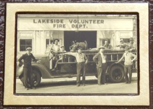
The Lakeside Volunteer Fire Protective Association responded to both fire and medical emergencies on the Marblehead Peninsula for more than 100 years. It was founded in 1905, after a devastating fire destroyed Lakeside’s business district. In 1946, the Association began providing emergency medical aid. During their service, the Lakeside Volunteer Fire Protective Association progressed from hand-drawn chemical carts to the area’s first heavy-duty fire and rescue truck. In 2013, the Association donated its assets to the newly-formed Danbury Township Volunteer Fire Department and passed into history.
, OH
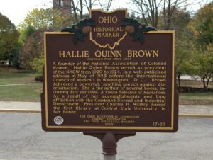
Hallie Quinn Brown (c. 1850) was born in Pittsburgh, Pennsylvania to former slaves. She and her family moved to Wilberforce, Ohio in 1870, where she received a Bachelor of Science degree from Wilberforce University in 1873. Brown taught school in the South until her appointment as professor of elocution at Wilberforce University in 1893. A gifted elocutionist and author, Brown received national and international acclaim not only for her recitals and written works, but also for her passionate belief in civil rights and African American culture. (Continued on other side)
, OH
Near this location stood the settlement of African American families known as “The Lett Settlement.” The Lett Settlement was a self-sustaining community of mixed race families, including the Caliman, Guy, and Lett families. The families had formed ties through marriage and common background during the mid-1700s in Virginia and Maryland. These early African American pioneer families came to Ohio as “free people of color,” and began acquiring land in Meigs Township, Muskingum County, and surrounding townships in adjacent counties during the 1820s. They were soon joined by the Brown, Clifford, Earley, Simpson, Tate, and Pointer families. The families of the Lett Settlement were land owners and tax payers in Ohio before the Civil War and challenged the State of Ohio for the right to vote and for access to education during the 1840s, 1850s, and 1860s. (Continued on other side)