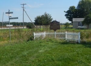
On this site, the Miami and Erie Canal, that came north from Cincinnati and the Ohio River, intersected with the Wabash and Erie Canal that came from Fort Wayne and Evansville, Indiana. From this point, which became the town of Junction, the canals proceeded as one to Defiance, Toledo, and Lake Erie. From the 1830s to the 1870s, the canals played a key role in the settling of Paulding County, an area that was once a part of the Great Black Swamp. They held the promise of easier and quicker passenger transportation and commodity shipping and Junction became a landmark for fugitive slaves escaping to Canada. Once a thriving and growing community, the village of Junction became a forgotten historical note with the passing of the canal era and the coming of the railroads. Today, the Buckeye Trail and North County Trail follow the canal path through Paulding County.
Early in the War of 1812, Gen. Wm. Hull, commander of Ohio troops, ordered Col. James Findlay to open a road from Ft. McArthur on the Scioto River to Blanchard’s Fork. Under Findlay, a stockade 50 yards square, with a blockhouse at each corner, was erected here and named in his honor. The fort was used as a supply depot.
This historic village was a hub for early Ohio industry and travel. The natural geography of the area provided ideal conditions for the establishment of a variety of mills. Col. Robert Patterson, an ancestor of the founder of National Cash Register in Dayton, John Patterson, chose Clifton for the site of a woolen mill, which furnished material for the American army during the War of 1812. Davis Mill, established in 1802 and in operation today as Clifton Mill, produced meal and flour for Civil War troops. A major stop on the stagecoach trail, “The Accommodation Line,” which ran from Springfield to Cincinnati from 1827 to 1840, the village bustled with the commotion of travelers. The once flourishing industry of Clifton faded as railroad traffic bypassed the village and manufacturers left the area.
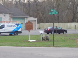
4401 Elk Creek Road (intersection of Howe & Elk Roads)
Middletown
, OH
The village of Miltonville, located along the banks of Elk Creek, was platted in 1816 by George Bennett, Theophilus Eaglesfield, and Richard V. V. Crane. The creek served two grist mills, one built around 1804 and operated by a free black, Bambo Harris, and the second was built by George Bennett in 1815. An Indian burial ground was located on the east bank of Elk Creek near the site of Huff’s Ferry. Eagle Tavern, the area’s first three-story brick inn, was a stopover for stagecoach lines traveling the Miltonville-Trenton Turnpike. The village was known for pottery factories, vineyards and wineries, and Frisch’s brickyard, established in 1880. The United Brethren Church, organized in 1811, and Miltonville Cemetery were the sites of church conferences and celebrations. The Miltonville School operated from the 1800s to 1936, and the local post office was in service during the years 1889-1904.
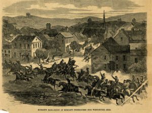
General John Hunt Morgan of Kentucky led a force of Confederate calvarymen into Meigs County during a forty-six day raid north of the Ohio River. The advance forces burned Benjamin Knight’s carding mill and sawmill, the Shade River Bridge, and pillaged local businesses in Chester on July 18, 1863, while waiting for the rest of the column to catch up. This two-hour halt delayed General Morgan’s arrival at the ford at Buffington Island until after dark, allowing Union troops to arrive before he could make his escape. General Morgan surrendered eight days later near West Point in Columbiana County, the northernmost point ever reached by Confederate forces during the Civil War.
Evansport is named after brothers Amos and Albert G. Evans who, with Jacob Coy, had the village surveyed next to the Tiffin River on December 14, 1835. The “port” suffix in Evansport’s name reflects the river’s significance as a transportation thoroughfare. Evansport’s early growth was spurred by its mills powered by the Tiffin River. The mills provided settlers with lumber for buildings and supplied flour and cornmeal for sustenance and commerce. Settlers who poured into Williams County’s northern townships in the 1830s agitated debate about moving the county seat to a more centralized location. Evansport was platted as a possible site for the county seat. The Williams County seat was moved to Bryan in 1840 and in 1845 Defiance County was created, leaving Evansport on the Williams-Defiance county line.
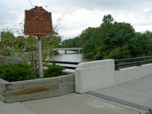
Completed in 1837, the limestone lock nine served as a catalyst for the growth of Piqua. The lock helped connect the village to Cincinnati (1837) and Toledo (1845) by way of the Miami and Erie Canal. German immigrants traveled up the canal from Cincinnati and settled within a five-block area of the lock. Industries used the lock as a source of water power and developed products as diverse as flannel, flour, and flax seed. Lock nine remained as a functioning part of the canal until its destruction during the flood of 1913.
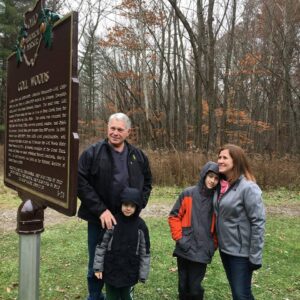
Two Deputy U.S. General Land Office Surveyors traversed Goll Woods: Benjamin Hough in 1815 and Captain James Riley in 1821. Hough (1772-1819) established the Michigan Meridian in 1815 and was county and state office holder in Ohio. Riley’s life was more tumultuous. Riley (1777-1840) captained the merchant ship Commerce, which wrecked off the Saharan coast in 1815. Riley and crew were enslaved for four months until ransomed by British diplomat William Willshire. In 1817, Riley published a famous account of his time in North Africa, and, in 1819, was appointed a surveyor by Surveyor General Edward Tiffin. Moving to Northwest Ohio, Riley named the village he founded in 1822, Willshire, for his deliverer. Riley returned to New York in 1826 and to the sea, where he died. Riley’s book went through more than twenty editions by 1860 and Abraham Lincoln credited the account as one that influenced him deeply.