

, OH
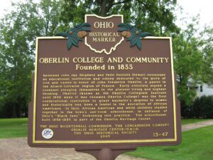
Reverend John Jay Shipherd and Philo Penfield Stewart envisioned an educational institution and colony dedicated to the glory of God and named in honor of John Frederick Oberlin, a pastor in the Alsace-Lorraine region of France. Early colonists signed a covenant pledging themselves to the plainest living and highest thinking. Oberlin (known as the Oberlin Collegiate Institute until 1850 when it was renamed Oberlin College) was the first coeducational institution to grant bachelor’s degrees to women and historically has been a leader in the education of African Americans. In fact, African American and white children studied together in the town’s one-room schoolhouse, in defiance of Ohio’s “Black laws” forbidding this practice. The schoolhouse, built 1836-1837, is part of the Oberlin Heritage Center.
, OH
Formed by the retreating glacier more than 14,000 years ago, Buckeye Lake first existed as a shallow, swampy pond, named “Buffalo Swamp” by Ohio Company explorer Christopher Gist in 1751. Beginning in 1826 the State developed it as a water source for the Licking Summit of the Ohio and Erie Canal, it being the highest level between the Scioto and Licking rivers. Engineers dammed the north and west sides of the swamp, inadvertently creating a unique floating sphagnum-heath bog surrounded by water. Cranberry Bog, with boreal vegetation typical of glacial-era Ohio, is a registered National Natural Landmark. (continued on other side)
, OH
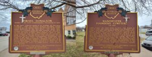
In May 1800, Congress passed an act dividing the Northwest Territory, with the western division becoming Indiana Territory and the eastern called the Territory of the United States northwest of the Ohio River. Two years later, thirty-five delegates from the nine counties of the latter division convened in Chillicothe to draw up the constitution for the new state of Ohio, which became a state in 1803. Israel Donalson was the last survivor of the convention dying in 1860 at the age of 93. This frontiersman served Manchester as a surveyor, schoolteacher, postmaster, and judge in the first court. In 1791, one month after his arrival here at Massie’s Station, Donalson was captured by Native Americans. His memoir is a colorful account of his capture and escape. Donalson served as an Elder for the first Presbyterian church in Adams County, which stood on these grounds.
, OH
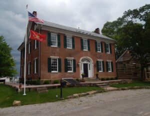
Erected in 1828, the Randolph Mitchell House is a five-bay, Federal-style “I” house. Its facade features a doorway with an Adam-style fan and sidelights. The interior boasts a grand stairway in the foyer and fine woodwork throughout. Randolph Mitchell (1796-1847) was born in Rockingham County, Virginia. In 1819, Mitchell and his mother Sarah (1765-1844), settled in New Reading and he married Lydia Witmer (1798-1872). They had four children. A merchant, Mitchell kept an ample smokehouse and owned a tannery and real estate. He served as a justice of the peace for Reading Township. After Mitchell’s death, his son-in-law, Dr. W.W. Arnold (1818-1872) maintained his practice in the home, where he and Caroline Mitchell Arnold (1825-1888) lived. Their son William Arnold (1858-1948) acquired the house, which remained in the family until 1951. The property was listed on the National Register of Historic Places in 1978.
, OH
Major buildings dating from 1832 to 1898 surround the village green, the geographic center of Gustavus Township. Built in 1832 on the northwest quadrant, the George Hezlep House features Federal-Greek Revival architecture and has a closet reputedly used on the Underground Railroad. Built in 1840, the Farmers’ Exchange Store was originally a double entrance Greek Revival structure. The Storekeeper’s House, also a Greek Revival structure, was built next to the exchange store in 1840. South of this house is the Fraternal Hall, built in 1870. There were once four churches in Gustavus including the Methodist Church, built in 1856 with a temple front and a belfry, and the Congregational Church, built east of the center in 1854. The eclectic Town Hall was built in 1890 and fronts the southeast quadrant. The Gustavus Centralized School, reported as the first centralized school in the United States, was built in 1898 and was replaced by the current building in 1928.
, OH
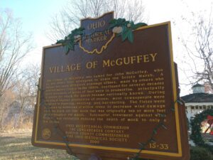
The Village of McGuffey was named for John McGuffey, who in the 1860s first attempted to drain the Scioto Marsh. A larger and more effective drainage effort, made by others who entered Hardin County in the 1880s, continued for several decades until thousands of acres of land were in production, principally of onions for which the marsh became nationally known. During the era of highest production of onions, most townspeople were involved in planting, weeding, and harvesting. The fields were bordered by windrows of willow trees to decrease wind damage over the black silt-like muck that was originally ten or more feet deep throughout the marsh. Successful treatment against wind erosion and oxidation reduced the depth of muck to only a few inches.
, OH
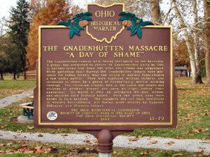
The Moravian Church in America began missionary work among the Delaware and Mohican tribes of North America in the mid-18th century. David Zeisberger, one of the best-known Moravian missionaries, came to the Ohio country with Delaware converts from a mission in western Pennsylvania and founded Schoenbrunn in the Tuscarawas Valley on May 3, 1772. Josua, a Mohican convert and missionary leader, led Mohican and Munsee Christians downriver and settled Gnadenhutten (“Tents of Grace”) on October 9, 1772. Zeisberger served as lead missionary at both villages. By 1775, there was an estimated 200 inhabitants in the village. The British, along with Wyandot and Delaware allies, suspected the Christian Indians of aiding the Americans. To ensure their allegiance to the British, the inhabitants of Gnadenhutten were forcibly removed in 1781 and taken to Captives’ Town on the Sandusky River.
, OH
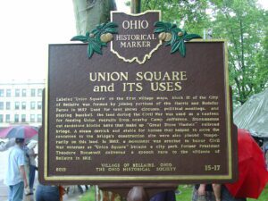
Labeled “Union Square” on the first village maps, block 12 of the City of Bellaire was formed by joining portions of the Harris and Rodefer Farms in 1857. Used for tent shows, circuses, political meetings, and playing baseball, the land during the Civil War was used as a canteen for feeding Union recruits from nearby Camp Jefferson. Stonemasons cut sandstone blocks here that make up “Great Stone Viaduct” railroad bridge. A steam derrick and stable for horses that helped to move the sandstone to the bridge’s construction site were also placed temporarily on this land. In 1882, a monument was erected to honor Civil War veterans as “Union Square” became a city park. Former President Theodore Roosevelt delivered a speech here to the citizens of Bellaire in 1912.