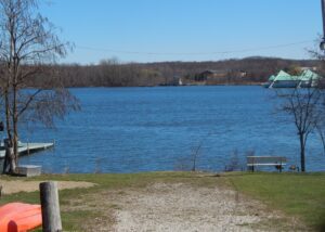
Geauga Lake, a scenic destination for visitors to northeast Ohio, was initially named “Giles Pond” after settler Sullivan Giles (1809-1880). In 1856, the predecessor of the Erie Railroad stopped at “Pond Station,” spurring the area’s growth. In the 1880s, locals established picnic grounds, a dance hall, and other facilities for those seeking a country getaway. Picnic Lake Park, later Geauga Lake Park, opened in 1887 and thereafter offered rides, a roller rink, photo gallery, billiard hall and bowling alley, among other attractions. In 1888, the Kent House hotel opened on the southeast side of the lake. In the century that followed, more attractions were added, including SeaWorld of Ohio, and the park expanded. In 2007, the melodic sounds of the carousel and the echoing screams from the “Big Dipper” roller coaster ceased when the park closed. (Continued on other side)
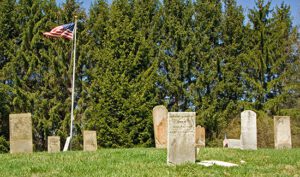
Smith’s Burying Ground was established in 1814 when John Smith (born 1742), Revolutionary War Veteran, died and was buried here. John Smith and four of his sons and their families made the six week, six-hundred-mile journey from New Jersey with ox teams the previous year. John Clouse (1758-1822), Dutch immigrant and Revolutionary War veteran, is also buried here. (Continued on other side)
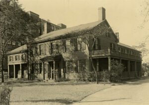
Dunham Tavern is the oldest building still standing on its original site in the City of Cleveland. Once a stagecoach stop on the old Buffalo-Cleveland-Detroit road (modern Euclid Avenue), the tavern dates from 1824. The structure was built by Rufus and Jane Pratt Dunham, who journeyed to the Western Reserve from Mansfield, Massachusetts. The Dunhams sold the tavern in 1853. However, it continued to serve the public until 1857, when it was converted to a private residence. It remained a home until the nineteen thirties, when commercial development threatened the former tavern’s existence. The historic structure was dedicated in 1936 as a museum depicting the life of an early Cleveland pioneer family. Dunham Tavern is listed in the National Register of Historic Places and is a designated Cleveland Landmark building.
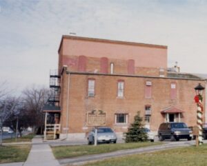
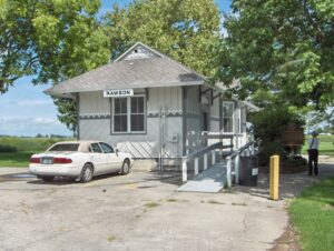
The freight depot east of this marker stands on the western terminus of Hancock County’s first rail link to the outside world. In 1849 the Mad River and Lake Erie Railroad Company opened a branch line from Findlay to its main line at Carey. A freight warehouse was built here ca. 1848 and passenger station in 1863. The Cleveland, Cincinnati, Chicago, and St. Louis Railroad replaced these earlier buildings with the present depot in the 1890s.
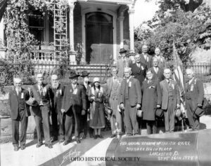
The 17th Infantry, created by Congress in 1812 and formed with personnel from western states, was the only Regular Army regiment in General James Winchester’s column of the Army of the Northwest’s campaign to regain Detroit. During the War of 1812, the 17th fought at Frenchtown, Fort Meigs, Fort Stephenson, and Thames River. In 1815, the 17th was consolidated with the 5th, 19th, and 28th Infantry to form the 3rd Infantry. In May 1861, the 17th Infantry was again organized as a Regular Army regiment and has since served continuously with distinction.
NE corner of S. Main Street and Zoar Road / Bayou Street
South Lebanon
, OH
Deerfield was laid out around 1795 and in 1802 Major Benjamin Stites, his son Benjamin, Jr., and John Gano officially recorded the village’s plat. A part of the great tide of Americans moving into the Northwest Territory (and Ohio after 1803), Deerfield’s early inhabitants included Revolutionary war veteran Ephraim Kibbey as well as Andrew Lytle, Nathan Kelly, William Snook, and War of 1812 veteran David Sutton. Deerfield was so called because it was a settlement in Deerfield Township, Hamilton County in the 1790s. (Continued on other side)
The original town plat of Rawson was filed on February 3, 1855, consisting of fifty-five lots in sections 13 and 14 of Union Township, Hancock County on the Frederick Keller and George J. Kelly farms. Several residential and business structures were built in anticipation of completion of a railroad rumored to pass from Fremont through the “Rawson” area on its way to the western boundary of Ohio. Farmers Keller and Kelly named their village Rawson after L.Q. Rawson, President of the railroad company, hoping that the name would encourage him to build through their area. Financial troubles delayed construction causing a standstill in Rawson. Seventeen years later the first locomotive arrived in Rawson, spurring new construction. At that time the railroad was called the Lake Erie and Louisville; in 1879 it was changed to the Lake Erie and Western and in 1922 became part of the Nickel Plate Railroad. (Continued on other side)
In April 1784, the Continental Congress adopted the Report of Government for the Western Territory, a broad plan drafted primarily by Thomas Jefferson for organizing the United States’ new western lands that were ceded by the states and purchased from Native Americans. One of the most far-reaching legislative acts in American history, the resulting Land Ordinance of 1785, passed on May 20th, established the public land system by which all federal land was surveyed and distributed. The Ordinance established a rectilinear survey system that divided land into townships of six miles square aligned by north-south and east-west baselines, and set aside certain lands for Revolutionary War veterans and for public schools.