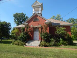
A fine example of the district school building common to Ohio in the early years of the twentieth century, this two-room, red-brick schoolhouse was completed in 1913. Accommodating elementary school children in east Berea and adjacent areas of Middleburg Township, the Berea “Little Red Schoolhouse” replaced an original wood-frame, one-room school built in the late nineteenth century on the same site. No longer active as a school, the building was used by the Berea Fine Arts Club from 1935 to 1980, and subsequently by the Berea Jaycees for meetings and community projects. This historic structure has been carefully restored and opened to public gatherings by the Berea Little Red Schoolhouse Foundation, Inc. It was placed on the National Register of Historic Places in 1975.
Garbry Conference Center and Learning Center, US 36
Piqua
, OH
J. Scott Garbry, a 1986 inductee into the Ohio Conservation Hall of Fame, had a lifelong commitment and passion for conservation, historic preservation, and education. His gift of land and artifacts to the Upper Valley JVS led to the creation of the Willowbrook Environmental Education Center and Garbry Museum. He was also instrumental in providing land for the site of the Piqua High School and for Garbry Woods of the Miami County Park District. These gifts make it possible to appreciate and experience Ohio’s natural and historic heritage.
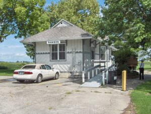
The original town plat of Rawson was filed on February 3, 1855, consisting of fifty-five lots in sections 13 and 14 of Union Township, Hancock County on the Frederick Keller and George J. Kelly farms. Several residential and business structures were built in anticipation of completion of a railroad rumored to pass from Fremont through the “Rawson” area on its way to the western boundary of Ohio. Farmers Keller and Kelly named their village Rawson after L.Q. Rawson, President of the railroad company, hoping that the name would encourage him to build through their area. Financial troubles delayed construction causing a standstill in Rawson. Seventeen years later the first locomotive arrived in Rawson, spurring new construction. At that time the railroad was called the Lake Erie and Louisville; in 1879 it was changed to the Lake Erie and Western and in 1922 became part of the Nickel Plate Railroad. (Continued on other side)
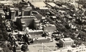
Named for the streetcar turnaround once located at Euclid Avenue and East 107th Street, University Circle is a 600-acre district that is home to many of Cleveland’s major cultural, educational, medical, and service institutions. The area was first settled in 1799 by tavernkeeper Nathaniel Doan and became known as Doan’s Corners. In 1882, Western Reserve College moved here from Hudson, followed in 1885 by the Case School of Applied Science from downtown Cleveland. These two colleges federated in 1967 to become Case Western Reserve University. (continued on other side)
201 Martin Luther King Drive (formerly: 201 Cass Avenue)
Marion
, OH
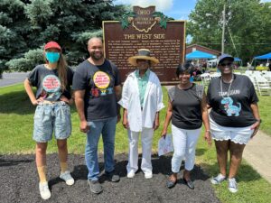
In the early twentieth century, Marion’s West Side was dominated by the Erie Railroad switchyards, a major hub of employment. During World War I, the railroad recruited Black workers from the South for jobs in its yards and roundhouses. In Marion, these workers made their homes in a West Side encampment that became the target of white suspicion and violence. In February 1919, following the unsolved murder of a white roundhouse worker’s wife and a separate alleged assault, a 300-man lynch mob smashed windows and occupied the West Side. All Black residents were ordered to leave the city by 6:00 pm the next day. Despite pleas to Governor Cox, at least 200 Black residents were forced to flee Marion. Marion’s anti-Black violence foreshadowed the nationwide “Red Summer” of 1919.
This area of western Hancock County is a part of the Maumee River Watershed known as “Indian Green.” Wyandot Indians chose this area for hunting and ceremonial grounds along the Blanchard River in the 1700s because it was next to the river, yet high enough to avoid frequent flooding. One-half mile east of this location is a Liberty Township cemetery. It is located upon a sand ridge once used as a burial ground by Indians, hence the name “Indian Green.”
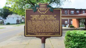
In 1866, Alliance physician, amateur horticulturalist, and politician Dr. Levi Lamborn propagated the scarlet carnation from French seedlings in greenhouses at this site. Opposing William McKinley for the 18th Congressional District in 1876, Lamborn presented the future president with a carnation boutonniere before each debate. McKinley, successful in those debates, continued to use the carnation as a good-luck charm, wearing the carnation in his lapel as president. On September 14, 1901, moments after removing the flower from his lapel and giving it to a young admirer at the Pan American Exposition in Buffalo, New York, President McKinley was killed by an assassin’s bullet. The Ohio General Assembly passed a joint resolution naming the scarlet carnation the state flower on February 3, 1904, as it “represented a token of love and reverence for the Ohio president.” On April 1, 1959, the Ohio Legislature proclaimed Alliance “The Carnation City.”
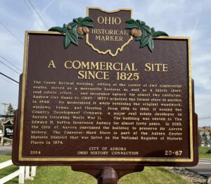
James Willard Converse (1806-1892) opened his store in 1825 at 10 South Chillicothe Road. Serving residents, merchants, and travelers, the store proved central to Aurora’s early commercial development. Converse’s Daybook survives as a glimpse into the habits of early citizens, who, along with household items, regularly purchased whiskey. Surprisingly, such sales surged on George Washington’s February 22 birthday. Converse deeded the business to employee Seth A. Gillett in 1834. Hopson Hurd Sr. (1793-1869) purchased it from Gillett in 1845. Hurd’s store was popular with local farmers who used their home made cheese as legal tender and enjoyed the barrel of whiskey kept in Hurd’s basement for customers who paid their bills. Hurd added a cheese warehouse to his store and, as a major exporter of cheese to Cleveland, Warren, and Pittsburgh, amassed a sizeable fortune.