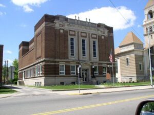
A group of Freemasons, inspired by the concepts of a new country, of Freedom with Responsibility, Brotherly Love, and Truth, formed Harmony Lodge near this site in 1809, the first Masonic lodge in western Ohio. Meetings were held in the log court house, located on Lot 174, East Court Street, and also in Dayton and Springfield.
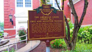
The lodge was organized in Roxbury, Massachusetts, on February 10, 1776, by Connecticut soldiers in the Continental Army. It met when and where it could during the Revolutionary War. By tradition, the lodge’s name and seal were suggested by Benjamin Franklin and the seal was engraved by Paul Revere. Many of the lodge members settled in the Marietta area following the war. On June 28, 1790, the lodge was reorganized in Campus Martius under its original warrant held by Past Master Capt. Jonathan Heart, commandant of Fort Harmer.
With a population of 475 residents, the Beallsville community gained the unfortunate distinction of having suffered the highest known per-capita casualty rate during the Vietnam War. Six Beallsville men, all under the age of 21, were killed in action in Vietnam between 1966 and 1971, a profound tragedy for this close-knit community. In 1969 Beallsville citizens worked with congressional representatives to prevent further loss of life, to no avail. Five other Monroe County men lost their lives in the conflict as well, magnifying the loss for one of Ohio’s least-populated counties. (continued on other side)
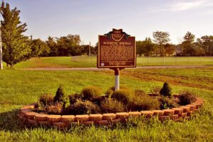
Near this site in 1879, J.E. Newhouse discovered a magnetic spring in his park, Green Bend Gardens. It was found that a knife blade dipped in the water could pick up small metal objects like a magnet. The spring became known for its curative powers and was advertised as a treatment for ailments including rheumatism, gout, insomnia, and diseases of the kidneys, bladder, and nerves. To share the health-giving water, Mr. Newhouse opened the Magnetic Bath House, which became famous for its water cures. To reach a larger market, the magnetic water was sterilized and bottled and sold under the Magnetic Springs label. Advances in medicine after World War II led to the decline in the popularity of mineral baths.
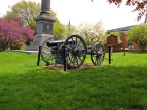
War of 1812. Victoriously defended by Major George Croghan. Battle of Fort Stephenson. August 2, 1813. Built on this spot 1812-1813 and named for Col. Mills Stephenson, one of its builders.
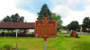
The ancient trail that passed near this spot was the major overland route entering the Ohio Country from the east through the 1700s. Also known as the Tuscarawas Path, the Great Trail was used by Native Americans, European explorers, fur traders, missionaries, military expeditions, land agents-and settlers after Ohio became a state. In January 1761, during the French and Indian War, Major Robert Rogers and thirty-eight rangers passed en route to Fort Pitt after taking Fort Detroit from the French. In 1764, during “Pontiac’s Conspiracy,” Colonel Henry Bouquet crossed here with an army of 1,500 men on his way to Goshachgunk (Coshocton), where he treated with the Delaware and freed captives. During the American Revolution, the Continental Army under General Lachlan McIntosh camped here for two days in November 1778.
The Northwest Ordinance of 1787 defined the boundary of the northern and southern tier of states to be carved out of the Northwest Territory, as a line drawn east from the southernmost tip of Lake Michigan until it intersects Lake Erie. Controversy over the exact location of that line led to the 1834-1837 boundary dispute between the State of Ohio and Michigan Territory. Passions ran high as everyone on both sides of the boundary knew that a great port city (Toledo) would emerge in the disputed territory. President Andrew Jackson settled the dispute in 1836 when he signed an act that recognized the current border between Ohio and Michigan, giving Michigan 9,000 square miles of Upper Peninsula land and awarding the disputed strip of approximately 470 square miles to Ohio. Michigan then joined the nation as a state the following year.
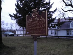
In April 1830 four Dominican sisters from St. Catherine’s, Kentucky, founded St. Mary’s Academy, the first Catholic school in Perry County. Bishop Edward Fenwick, first Bishop of Ohio, donated a small brick house and attached building situated on an acre of land for the school’s use. Classes began with forty students. The following year the sisters built a three-story structure with a dormitory for boarders; by the end of the Civil War, enrollment had increased to 134 students, and St. Mary’s gained recognition as one of the finest schools in Ohio. An 1866 fire destroyed the academy, and in 1885 the Dominican sisters reestablished the academy as a parish school. The present Holy Trinity School building dates to 1968.