Old Erie received its original charter on October 19, 1803, from the Grand Lodge of Connecticut. In 1808, the lodge joined with five other Ohio lodges to organize the Grand Lodge of Ohio. The first man to preside as Grand Master of the Grand Lodge of Ohio was Governor Samuel Huntington, a member of Old Erie Lodge. [Masonic Emblem]
In 1787, the construction of Fort Steuben was completed by Captain John Francis Hamtramck and soldiers of the 1st American Regiment, who were sent to the frontier by the United States government to remove illegal squatters and protect government surveyors from American Indian raids. The surveyors were platting the First Seven Ranges of the Northwest Territory. The surveyed land was sold for settlement or offered to soldiers as payment for military service during the Revolutionary War. Consequently, the states of Ohio, Illinois, Indiana, Michigan, and Wisconsin were formed from the settlement of the Northwest Territory. Fort Steuben was named after Baron Frederich Wilhelm Augustus Steuben, who had served in the Revolutionary War and from which the town derived its name. Captain Hamtramck abandoned the fort in 1787 by order of Colonel Josiah Harmar, and by 1790 the remains of the fort had disappeared. Fort Steuben has been reconstructed on its original location.
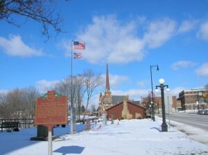
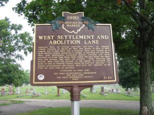
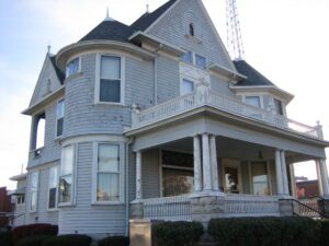
Augustus West, an African American, was born in Madison County, Virginia on March 20, 1814, and moved to Ohio in 1837. Legend has it that West was a runaway slave and worked as a farm laborer before designing a scheme to purchase his own farm. West, with abolitionist Alexander Beatty, traveled into slave territory no fewer than three times where the pair would sell West, help him escape, and split the profits. After splitting the profits, West used his portion of the money to purchase 177 acres of land in Fayette County where he built his “mansion.” To remain inconspicuous and secure, West built the “mansion” as far from the main road as possible. (continued on other side)
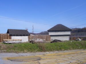
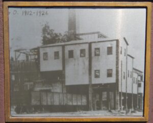
Approximately 150 feet east stood the Hisylvania Coal Company Mine No. 22 tipple, in use from 1912 to 1925. The company name was derived from combining “Ohio” and “Pennsylvania,” home states of its founders. Coal came from the mine portal in small railcars, was cleaned and sized in the tipple, and loaded into gondolas for shipment. The Mine No. 22 tipple had a brick and concrete frame, likely the only one of this type in Ohio. When demolished in 2000, it was one of the last tipples still standing as a reminder of Ohio’s 1880-1920 coal boom and the Hocking Valley coal field’s contribution during this era.
The museum of the Mercer County Historical Society, the Riley Home represents six generations of the Riley family in the county. The first Riley to arrive here was Captain James Riley, who surveyed the area in 1819, after it was opened to American settlement following the Treaty of Saint Marys in 1818. Captain Riley was elected to the Ohio General Assembly in 1823. Captain Riley’s son, James Watson Riley platted Celina in 1834, was Mercer County’s Clerk of Courts, and then represented the area in the Ohio General Assembly beginning in 1843. (Continued on other side.)
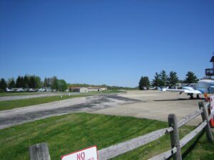
Daniel E. Weltzien, pilot and hometown son, dreamed of a flying community – one where every family would have a plane in their garage for work or play. In June 1965, the Williams Farm on Acme Hill became a runway with taxiways to every home. Young men and women came for flying lessons, and now traverse the world in space, the military, and commercially. Surviving fire, tornadoes, an earthquake, Ohio winters, and severe crosswinds, students still come here to take their first flight and become pilots. In Ohio, birthplace of aviation pioneers, this is “SKYPARK” THE FLYING COMMUNITY, a first in Ohio because a man dared to dream.
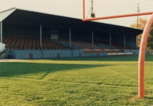
Opened in 1926, Tanks Memorial Stadium became the home of the Ironton Tanks semi-professional football team. The Tanks were formed in 1919 and through the years played other semi-professional teams as well as teams from the American Professional Football Association that became the National Football League in 1930. In twelve seasons the Tanks had a record of 85 wins, 19 losses, and 14 ties, including wins against the Chicago Bears and New York Giants. The Tanks disbanded in 1931, but five players moved on to the Portsmouth Spartans, which became the Detroit Lions, and other NFL teams picked up four other players. Tanks Memorial Stadium is one of the few remaining roofed high school football stadiums in the country.
Southeast of this point are the Big and Little tunnels. They were links in the 73-mile Sandy and Beaver Canal which connected the Ohio River with the Ohio and Erie Canal. Shifts of Irish laborers worked night and day with hand drills and blasting powder to cut the 1,060-yard Big Tunnel which opened for commercial use in 1850 and was abandoned two years later, a victim of the railroad.