In 1769, Pierre-Louis de Lorimier (Peter Loramie) traveled from Canada to this vicinity to establish fur trading with the local indigenous tribes. This location is a portage between tributaries of the Ohio River and Lake Erie that eased the transport of the quantity of furs in this lucrative trade. His very profitable trading post was located just west of this marker along Loramie Creek. Lorimier’s friendship with the local Shawnee and Delaware tribes, and the British, led him to join them in efforts to curtail the movement of white settlers into the Northwest Territory. In 1782, in an attempt to halt raids along the Ohio River (many of which were formulated at Lorimier’s store), General George Rogers Clark ordered Col. Benjamin Logan to burn Lorimier’s store.
Site of the first fortified settlement in Anderson Township and one of the first in the Virginia Military District. John Garard and Joseph Martin were the founders of this Station, who, with Elias Garard, Joseph Frazee, and others, came by two flatboats with families and livestock from Garards Fort, Pennsylvania, via the Ohio and Little Miami rivers. They landed here on December 23, 1790, and proceeded to erect the fortification.(Continued on other side)
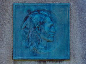
Tah-gah-jute, the Mingo chief named Logan, was a native of Pennsylvania. Logan moved to Ohio in 1770, and settled at the Pickaway Plains. Logan and his father, Shikellimus, had long supported friendships between Native Americans and white men; however, in the spring of 1774, his tribesmen and family were murdered at Yellow Creek, along the Ohio River. Once an advocate of peace, Logan went on the warpath and raided frontier settlements. These and similar raids along the Ohio frontier precipitated Lord Dunmore’s War in October 1774. After the Shawnees and their allies were defeated at Point Pleasant, Virginia governor Lord Dunmore marched up the Hocking River to the Pickaway Plains. Dunmore asked his interpreter, Colonel John Gibson, to assist in negotiations with Cornstalk and other Indian leaders, including Logan. Logan declined to attend the conference, but spoke to Gibson about his anger and betrayal.
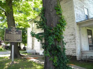
In 1805, for $1.50 an acre, Jacob Miller purchased this property in the Congressional Land Office in Chillicothe, capital of the new state of Ohio. He and Somerset co-founder John Finck then each built a tavern on either side of town along the Zane’s Trace, laid out along existing Indian trails in 1796-1797 and Ohio’s first major thoroughfare. Finck built his home and tavern in 1807 and Miller his shortly after. From 1800 to 1815, Zane’s Trace saw significant traffic between the established eastern states and the newly opened Northwest Territory. A perpetual stream of emigrants rolled westward, giving constant occupation to hundreds of tavern-keepers. Besides operating his tavern and farming, Jacob Miller was a public servant. In 1809, he was appointed Overseer of the Poor as there was a need to “bind out” poor children to families who could take care of them. [continued on other side]
From the 1770s until 1832, the Logan County area was the homeland to much of the Shawnee Nation. Ten villages known as the Upper Mad River towns included the homes of influential leaders Moluntha, Black Hoof, and Blue Jacket. The West Liberty area contained three villages: Moluntha’s Town, Wapakoneta, and Mackachack. To the northeast stood Wapatomica, the Shawnee’s political center and site of several intertribal councils. To the north sat Blue Jacket’s Town, Kispoktha Town, and Reed Town. To the west were Pigeon Town and Stony Creek, site of one of Tecumseh’s first pan-Indian confederacy councils. From 1817 to 1832, many Shawnees were relocated to Indian Territory, which in 1907 became the state of Oklahoma. These Shawnees are now the Eastern Shawnee of Oklahoma.
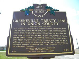
The Treaty of Greeneville created the Greeneville Treaty Line. It was the boundary between lands in the original possession of the Indians and those they ceded to the United States, which were south and east of the boundary. Major General “Mad” Anthony Wayne negotiated the treaty with the tribes his army defeated at the Battle of Fallen Timbers on August 20, 1794. Leaders of 12 tribes, including Wyandots, Delawares, Shawnees, Ottawas, and Miamis, signed the Treaty of Greeneville on August 3, 1795 with General Wayne, William Henry Harrison, and other representatives of the United States. Treaties that followed Greeneville up to the Treaty with the Miamis in 1818 extinguished the various tribes’ original claims and created Indian reservations on the lands northwest of the Greeneville Treaty Line, making it obsolete. (Continued on other side)
Unsatisfied by the terms of the treaty that ended the French and Indian War, Ottawa chief Pontiac led a confederacy of Native American tribes in attacks against British frontier forts during 1763, a campaign known as “Pontiac’s Conspiracy.” In October 1764, Colonel Henry Bouquet led a 1500-man army into the Ohio country from Fort Pitt (present-day Pittsburgh) as a demonstration of British force and to free captives held by several tribes. Informed of possible attack, Bouquet diverted his army overland from his Tuscarawas River valley route and here deployed his forces into three lines: a group of scouts on each ridge and the main force along present Route 93. Evidence of artillery emplacements and infantry breastworks remained visible for many years.
First known as the Webster House, later as the New England House, and finally as the Old Tavern, this inn has served travelers on the old Cleveland-Buffalo Road (now State Route 84) since before Ohio became a state. As traffic on the old Indian trail increased and it became a post and stage road, the two original log cabins, built in 1798 and later, were converted to this two-and-a-half story inn between 1815 and 1820. While the tavern was the scene of Civil War-era parties and dances in the second-floor ballroom, local tradition suggests it offered much more clandestine hospitality to escaping slaves as a station on the Underground Railroad. The Unionville Tavern was added to the National Register of Historical Places in 1973.