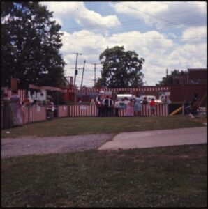
Brown County Fairgrounds off W. State Street/OH 125
Georgetown
, OH
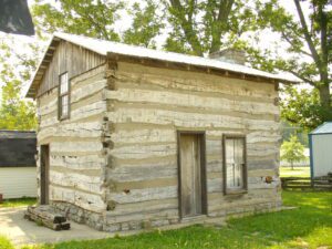
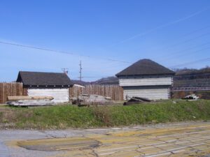
This house originally stood at Logan’s Gap, Union Township. By tradition, it was constructed in 1793 by Indian scouts William Dixon and Cornelius Washburn who became residents of Brown County. Dixon lived in this house until 1800.
Tensions between Native Americans and Euro-American settlers remained high on the Ohio frontier during the War of 1812. Grievances mounted rapidly following the forced removal of the Greentown Delawares to Piqua in the late summer of 1812. On September 10, British-allied Indians attacked and killed the Frederick Zimmer family and neighbor Martin Ruffner one mile north of here. Five days later, on September 15, Reverend James Copus and three militiamen–George Shipley, John Tedrick, and Robert Warnock–were killed while defending Copus’ family from a raiding party one mile south of this site. (continued on other side)
In the 1820s a general store and grist mill were established on this site, where the famous Scioto-Sandusky Indian trail neared the Sandusky River. The settlement was first known as McNutt’s, later as Swope’s Corners. The village of Fort Seneca was surveyed January 14, 1836. Its name was derived from Gen. Harrison’s War of 1812 fort, which was located a few miles downstream.
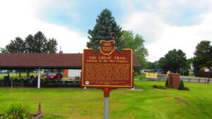
The ancient trail that passed near this spot was the major overland route entering the Ohio Country from the east through the 1700s. Also known as the Tuscarawas Path, the Great Trail was used by Native Americans, European explorers, fur traders, missionaries, military expeditions, land agents-and settlers after Ohio became a state. In January 1761, during the French and Indian War, Major Robert Rogers and thirty-eight rangers passed en route to Fort Pitt after taking Fort Detroit from the French. In 1764, during “Pontiac’s Conspiracy,” Colonel Henry Bouquet crossed here with an army of 1,500 men on his way to Goshachgunk (Coshocton), where he treated with the Delaware and freed captives. During the American Revolution, the Continental Army under General Lachlan McIntosh camped here for two days in November 1778.
The West Liberty area, in the Mad River Valley, was the location of at least seven Shawnee Indian villages. This elevated site was the location of one of those villages. Several septs or divisions of the Shawnee nation lived in this area after being forced from their homes in southern Ohio. In 1786, together with Simon Kenton, Colonel Benjamin Logan’s army destroyed all the Shawnee villages in retaliation for the Indian raids in southern Ohio and Kentucky. Consequently, the remaining Shawnees moved to northwest Ohio near the present-day site of Maumee.
In 1787, the construction of Fort Steuben was completed by Captain John Francis Hamtramck and soldiers of the 1st American Regiment, who were sent to the frontier by the United States government to remove illegal squatters and protect government surveyors from American Indian raids. The surveyors were platting the First Seven Ranges of the Northwest Territory. The surveyed land was sold for settlement or offered to soldiers as payment for military service during the Revolutionary War. Consequently, the states of Ohio, Illinois, Indiana, Michigan, and Wisconsin were formed from the settlement of the Northwest Territory. Fort Steuben was named after Baron Frederich Wilhelm Augustus Steuben, who had served in the Revolutionary War and from which the town derived its name. Captain Hamtramck abandoned the fort in 1787 by order of Colonel Josiah Harmar, and by 1790 the remains of the fort had disappeared. Fort Steuben has been reconstructed on its original location.
Intersection of Main Street and Township Road 39 (High Street)
Roundhead
, OH
Upon this site, in the late 18th and early 19th centuries, stood Chief Roundhead’s Wyandot Indian village. This flourishing agricultural community later gave way to white settlement and Hardin County’s first town was laid out here in 1832. Roundhead, or Stiahta, was celebrated for his capture of American General James Winchester during the War of 1812. Roundhead is believed to be buried in this vicinity.
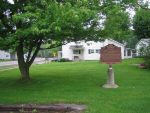
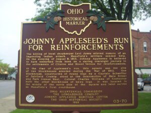
The killing of local shopkeeper Levi Jones stirred rumors of an impending Indian attack. Mansfield’s settlers needed help. On the evening of August 9, 1813, Johnny Appleseed is believed to have embarked from here on a daring overnight journey to the settlements of Clinton and Mount Vernon for reinforcements. At the time of Appleseed’s run, this square was the site of two blockhouses erected during the War of 1812. One blockhouse, constructed of round logs by a Captain Schaeffer of Fairfield County, stood at the intersection of Main Street and Park Avenue West. Colonel Charles Williams of Coshocton built the other blockhouse of hewn logs. It was located in the middle of the north side of the square and later served as Mansfield’s first courthouse.