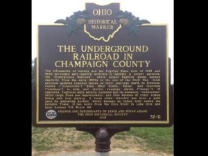
The inhumanity of slavery and the Fugitive Slave Acts of 1793 and 1850 motivated anti-slavery activists to operate a covert network, the “Underground Railroad,” which helped fugitive slaves escape captivity. From the early 1800s to the end of the Civil War, local activists assisted runaway slaves on their journeys north to freedom. Guides (“conductors”) used their homes, farms, and churches (“stations”) to hide and shelter runaway slaves (“cargo.”) If captured, fugitives were severely punished and re-enslaved; “conductors” faced large fines and imprisonment, and Free Persons of Color risked being sold into slavery. A route often-traveled was once a path used by migrating buffalo, which became an Indian trail called the Bullskin Trace. It ran north from the Ohio River to Lake Erie and later became U.S. Route 68.
The Indian Creek Regular Baptist Church was established in 1810 as an arm of the Little Cedar Creek Church of Brookville, Indiana. The congregation purchased three acres of land for a burial ground and church and built a log structure here in 1811. Members voted in 1812 that they would receive no person who believed in the principles of slavery. By 1829, membership had reached 150 and the present brick meeting house was built. In the 1840s, membership declined due to conflict over mission activity The congregation dissolved in 1879 and the land was deeded to the Indian Creek Cemetery Association in 1880. The county park system received the property in 1960 through and with the cooperation of the Butler County Historical Society and the Cemetery Association.
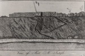
In 1785, American Indian tribal leaders from the Chippewa, Delaware, Ottawa, and Wyandot met with representatives sent by the United States Congress to sign the controversial Treaty of Fort McIntosh. The treaty surrendered control of Native American lands in southern and eastern Ohio to the United States government. Most Indians rejected the validity of the treaty and rather than improving relations, the Treaty of Fort McIntosh only intensified the tensions that existed between the United States government and the Indian tribes. This marker signifies the eastern most portion of the American Indian territory outlined by the treaty. The Portage Path, a trail used by American Indians as a portage between the Cuyahoga and Tuscarawas rivers, became a part of this boundary line.
Mesopotamia Township, Trumbull County was a part of the Western Reserve, 3.3 million acres in Northeast Ohio claimed by Connecticut. After the Treaty of Greenville extinguished American Indian title in 1795, the state sold most of the land to the Connecticut Land Company (except for the Firelands to the west). The company’s proprietors then sold the land to settlers from Connecticut and the east and they in turn brought to the west their ideas for what a solid home should look like. (Continued on other side)
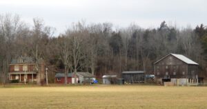
Lewis-Sample Farmstead. The farmstead shares the name of the Lewis and Sample families, two owners since European-descended settlers began moving into the Ohio County in the late 1700s. Andrew (1762-1847) and Martha Lewis (1774-1852) acquired this land in 1804. Like others, Andrew saw for himself the rich land north of the Ohio River while in the army during the Ohio Indian Wars of the 1790s. By 1834, the Lewis farmstead had expanded to more than 350 acres with a brick house, still house, and sawmill on Indian Creek. The Sample family purchased the farm in 1871 and owned it until 2007.
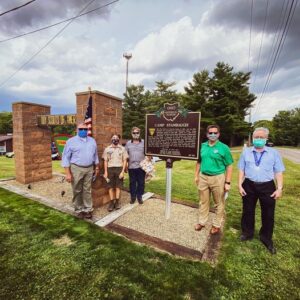
The Boy Scouts of America began in 1910, and by 1912, Scouting was established in the Mahoning Valley. Camp Stambaugh opened in July 1919, thanks to a gift from the estate of prominent local industrialist Henry H. Stambaugh (1858-1919). In his will he had named his friend and business partner Phillip J. Thompson as trustee of Stambaugh’s 86.5 acre Indian Creek Farm. Stambaugh’s expectation was that Thompson would convey the property to the local Scouting organization. In 1919 the property was mostly a treeless pasture and one could see Indian Creek from Stambaugh’s hay barn near Leffingwell Road. That first summer a Council Ring was carved from an old limestone quarry just north of the creek. (Continued on other side)
Recognized for their biodiversity and high quality aquatic habitat, Big Darby Creek and Little Darby Creek were designated as state and national scenic rivers. These riparian ecosystems provide modern recreational opportunities while allowing a sense of their appearance centuries ago. Nearby Indian mounds indicate that the Darby creeks have been important food and transportation resources for thousands of years. More than 100 species of fish and 40 species of freshwater mollusks have been recorded within these watersheds. Several, including the indigenous Scioto Madtom, are locally and federally endangered.
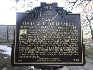
Ovid Wellford Smith, aged 16, enlisted in the 2nd Ohio Volunteer Infantry as James Smith. He volunteered for the 1862 “Andrews’ Raid” mission to destroy Confederate supply lines. Enroute Smith became ill and was detained near Huntsville, Alabama, prior to the April 12 capture of “The General” locomotive at Big Shanty, Georgia. He escaped and made his way back to rejoin his Army unit. On July 6, 1864, Smith and 5 other raiders were awarded the Medal of Honor. He mustered out October 1864 at the rank of corporal, after participating in the Battles of Chickamauga, Chattanooga, and Missionary Ridge.