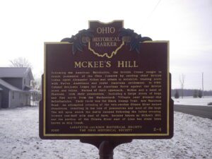
Following the American Revolution, the British Crown sought to retain possession of the Ohio Country by sending chief British Indian Agent Alexander McKee and others to establish trading posts with Native Americans and resist American settlement. In 1786, Colonel Benjamin Logan led an American force against the British posts and tribes. Warned of their approach, McKee and a band of Shawnee, took their possessions, including a large drove of hogs, and fled north from the Mackachack Villages near present-day Bellefontaine. Their route was the Black Swamp Trail, now Napoleon Road. An attempted crossing of the rain-swollen Ottawa River turned disastrous, resulting in the loss of possessions and most of the hogs. The hill upon which the party camped following the failed crossing, located one half mile east of here, became known as McKee’s Hill, and the portion of the Ottawa River east of Lima has since been known as Hog Creek.
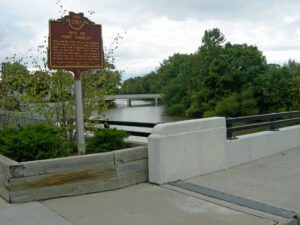
Early in the War of 1812, Gen. Wm. Hull, commander of Ohio troops, ordered Col. James Findlay to open a road from Ft. McArthur on the Scioto River to Blanchard’s Fork. Under Findlay, a stockade 50 yards square, with a blockhouse at each corner, was erected here and named in his honor. The fort was used as a supply depot.
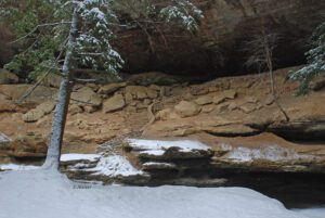
This recess cave was named for the “old man” Richard Rowe, a recluse who made the cave his home in the 1800s and is a part of scenic Hocking Hills State Park. Hocking comes from the Wyandot Indian word “hockinghocking,” referring to the Hocking River’s bottle-shaped gorge near Lancaster. Streams and percolating groundwater carved the hollows and caves in this area from layers of sandstone bedrock that vary in hardness. The hollow’s moist, cool climate preserves more typically northern tree species such as eastern hemlock trees and Canada yew, which have persisted since the glaciers retreated 15,000 years ago.
The Plains lay south and west of the Sandusky River, bounded by the Olentangy River on the east and Tymochtee Creek on the west. The local black prairie soils mark the extent of the grasslands, which were uncommon in the dense eastern forests. Bur Oak trees, from the period of the Wyandot Indians, have survived because their thick bark protected them from the common prairie grass fires. This remnant of wilderness–Bur Oak Grove and Tall Grass Prairie–is protected from cultivation, which would destroy most of the native plant species.
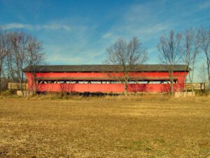
The Pottersburg Bridge, sometimes called the Upper Darby Bridge, was designed and constructed by Reuben Partridge in 1868. Originally located on North Lewisburg Road spanning the Big Darby Creek, the bridge was moved to this North Lewisburg Trail location in 2006 and renovated by Union County Engineer Steve A. Stolte to preserve its 1930s appearance. Its windows with awnings are not original, having been added prior to the 1930s. The steel rods were likely added in 1949. Partridge was a prolific bridge builder, having built more than 100 bridges in Union and surrounding counties. Most of his bridges were built with wood and covered, but a few were constructed with iron.
This historic village was a hub for early Ohio industry and travel. The natural geography of the area provided ideal conditions for the establishment of a variety of mills. Col. Robert Patterson, an ancestor of the founder of National Cash Register in Dayton, John Patterson, chose Clifton for the site of a woolen mill, which furnished material for the American army during the War of 1812. Davis Mill, established in 1802 and in operation today as Clifton Mill, produced meal and flour for Civil War troops. A major stop on the stagecoach trail, “The Accommodation Line,” which ran from Springfield to Cincinnati from 1827 to 1840, the village bustled with the commotion of travelers. The once flourishing industry of Clifton faded as railroad traffic bypassed the village and manufacturers left the area.
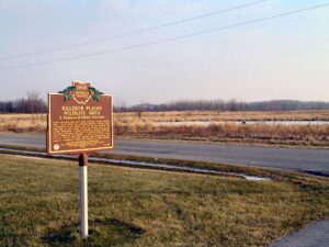
Prairie grasslands were once widely scattered across western Ohio. One of Ohio’s best remaining prairies, Killdeer Plains is dominated by tall grasses such as the big bluestem and plays host to some unique species of wildlife such as the eastern massasauga or swamp rattlesnake. Prairie grasslands are one of the most rare types of wildlife habitats in the state. Named for the killdeer, a shore bird, this is part of a wet prairie that once spanned some 30,000 acres and boasts a tremendous number and diversity of native wildlife.
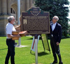
Wyandot County’s third and current courthouse was constructed from 1899-1900. Designed by the firm of Yost & Packard, the architects of courthouses in Wood, Harrison, and other counties, the building is a wonderful example of Beaux-Arts Classicism. The third floor courtroom was featured in the 1994 motion picture “The Shawshank Redemption,” based on a Stephen King novella. Director-screenwriter Frank Darabont chose the courtroom for the opening scenes of the movie, which features Academy Award-winning actors Tim Robbins and Morgan Freeman. Many courtroom “extras” were Wyandot County residents. A time capsule inside Lady Justice, atop the dome, contains a copy of the movie, commemorating ‘Shawshank’ enthusiasts who supported the statue’s 2009 restoration. A restoration of the building was completed in 2015. The courthouse and adjacent jail were listed on the National Register of Historic Places in 1973.