

, OH
A network of Native American trails, usually following waterways, traversed Ohio and often determined the routes of military roads and improved highways. U.S. Route 33 follows the route of the Scioto Trail from the confluence of the Scioto and Olentangy rivers to State Route 161, where U.S. Route 33 becomes State Route 257. The Scioto Trail extended from the mouth of the Scioto River at Portsmouth (also known as Shawnee Town) to Sandusky Bay and connected the Shawnee’s hunting grounds in Kentucky with Lake Erie. The trail ran along the Scioto River, the Little Scioto River, and the Sandusky River with a portage between the Little Scioto and Sandusky rivers in Crawford County. The Scioto Trail, used for warfare, trade, and migration, was one of the most important trails in the Old Northwest.
, OH
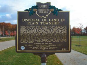
Because three distinct survey methods were used to survey Plain Township lands and are still meaningful, the township can be thought of as a surveyor’s museum. The township came into existence by a 1796 act of Congress in which the federal government established a Military District of Ohio to satisfy the claims of Revolutionary War veterans. The act divided the district into townships five miles square divided into four quarter-sections containing 4,000 acres each. These boundaries were surveyed in 1797 after the Battle of Fallen Timbers and the subsequent Treaty of Greenville, which forced Indian removal. Because a veteran was entitled to 100 acres, the southeast quarter of the township was surveyed into 40 hundred-acre lots. From 1801 to 1805, veterans, their heirs, and assignees, none of whom settled permanently in the township, claimed 24 lots. Abijah Holbrook, a land speculator, acquired veterans’ warrants for the remaining sixteen. (continued on other side)
, OH
In 1931, the France Stone Company ceased operations. Robert Burge leased 19 acres of the site for recreational swimming and opened Centennial Quarry in 1934. Five years later, Burge and associates opened Centennial Terrace, whose centerpiece was “Dancing Under the Stars,” an outdoor, 10,000 square-foot Terrazzo dance floor. Centennial Terrace was a regular stop for many big bands of the 1940s and ’50s. In 1969, the complex was donated to Lucas County and local band leaders kept the people dancing from 1971 to 1993. In 1994, the City of Sylvania leased the facility and renovated and reopened the quarry. The Sylvania Area Joint Recreation District purchased the complex in 2007 and made further improvements to insure that Centennial Terrace and Quarry remains a popular recreation destination.
, OH
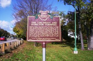
Population growth in the newly settled communities of Cincinnati (1788) and Hamilton (1791) led to a call to improve the early Native American and military foot trail that connected the two settlements. The Cincinnati and Hamilton Turnpike Company was incorporated in 1817 to construct a turnpike between the two communities. With a capital-stock value of $100,000, the company set about to markedly reduce the thirty mile trip to two days travel time. From this turnpike emerged a tollgate at this site to collect tolls to pay for maintenance of the road. Blacksmith shops to tend to vehicle and horse needs and several inns to house weary travelers were also established at this site. One inn, “The Century Inn,” established in 1806, continues to operate as one of Ohio’s oldest.
, OH
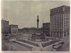
This monument, dedicated July 4, 1894, honors Cuyahoga County men and women, who performed military and patriotic duties during the Civil War (1861-1865). William J. Gleason (1846-1905), army veteran and local businessman, proposed its creation in 1879. Captain Levi Tucker Scofield (1842-1917), Cleveland architect and sculptor, designed the structure and supervised its 19-month construction by contractors, A. McAllister and Andrew Dall. George T. Brewster of Boston and George Wagner of New York, professional artists, assisted Scofield as sculptors. A 12-member Monument Commission, appointed by Governor Joseph B. Foraker in 1888, oversaw the project, which included the removal of William Walcutt’s 1860 marble statue of Commodore Oliver Hazard Perry from the site. The monument’s cost of $280,000 was raised by a countywide property tax levy. An 11-member commission maintains the monument funded by the county. (continued on other side)
, OH
The town of Bedford was settled in 1837. Early residents, Hezekiah and Clarissa Dunham donated the land that serves as Bedford Public Square. The Dunhams built one of the area’s first homes in 1832, which stands at 729 Broadway with the letters H & D above the doorway. Early settlers were attracted to the area by the abundance of natural resources and a large waterfall for mill sites. Bedford also served as a stagecoach stop on the route from Cleveland to Pittsburgh. The road or Turnpike Road as it was called was originally part of the Mahoning Indian Trail. By 1895 the road was renamed Main Street (and later Broadway) when the Akron, Bedford, and Cleveland Railway Company (ABC) traversed the middle of the street carrying passengers. The interurban is called “America’s first high speed long distance electric interurban” with speeds in excess of 60 miles per hour. [continued on other side]
, OH
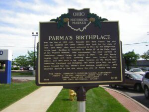
With the War of 1812 over, Benajah and Ruth Wilcox Fay and their ten children left Lewis County, New York for the state of Ohio. Like many, they were attracted to Ohio by the inexpensive, fertile land. Settling in Township 6, Range 13 of the Blake Tract of the Western Reserve, they represented the first settlers of Greenbriar, named Parma on March 7, 1826. The Fay family cleared their new land, including what later became Theota Avenue, and then built a log cabin. Located on the wagon trail connecting Cleveland and Columbus, the cabin grew into the well-known Benajah Fay Inn, Parma’s first business establishment. This historical marker is the site where the city of Parma was born.