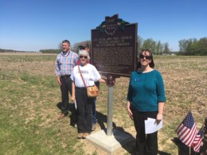
Saints Peter and Paul Church, Petersburg (1835), was the mother church for St. Joseph, Wapakoneta; St. John the Evangelist, Fryburg; St. Lawrence, Rhine; and Our Lady of the Immaculate Conception, Botkins. All were founded by German-Catholic immigrants to west-central Ohio. After the removal of the Wapakoneta Shawnee in 1832, the land became available for purchase. The 1830s and ’40s saw a wave of devout German settlers who wished to practice their faith in their new home, a desire served by missionary priests such as Father Wilhelm Horstman. Father Horstman first visited the settlement at Petersburg on May 8, 1835, presiding at Mass, baptizing, and blessing a marriage. In April 1836, immigrants John and Anna Mary Ruppert sold 40 acres of land in Pusheta Township to the trustees of the Catholic Church and a log church was built at the Petersburg site. (Continued on other side
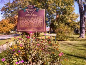
This is the site of Camp Noble, named for Congressman Warren P. Noble, who obtained the officer’s commission for William H. Gibson as the colonel of the 49th Ohio Volunteer Infantry. Companies of 100 began to arrive here August 12, 1861 from Crawford, Hancock, Putnam, Sandusky, Seneca, and Wyandot Counties. On August 20, they were mustered into Federal service as the 49th Ohio Volunteer Infantry. Nicknamed the “Buckeye Vanguard” by Col. Gibson, training continued until September 9, 1861, when the 49th was ordered to Camp Dennison, near Cincinnati, Ohio. (Continued other side)
Named for General Zebulon Pike, killed in the War of 1812, Pike County was organized in February 1815. Commissioners were charged with establishing a county seat and on May 12, 1815 accepted a conveyance of 40 acres from Elisha Fitch. The new seat was named “Piketon.” In 1816, the commissioners let a contract for the construction of a courthouse and jail. A fine two story courthouse with brick laid in Flemish bond was finished in 1819. A fire destroyed some country courthouse offices on October 9, 1844. The repaired courthouse was the seat of county government until 1861 and is part of the Piketon Historic District, which was listed on the National Register of Historic Places in 1974. Limestone headers above the windows have the names of the county government offices.
SW Corner of Sunbury Square near S. Columbus St & E. Granville St.
Sunbury
, OH
When Sunbury was platted in 1816, a town square was set aside for public use with the intention of constructing a town hall on the site. The first two stories of the Town Hall were built, as a school, in 1868 for $5,000. The Masons added the third story for $1,500 and occupied it for 91 years, until a lodge was constructed. Since 1868, the Town Hall has served Sunbury as a village office building, jail, fire station, and community library. Church services as well as Farmer’s Institutes were held in the building, and at one time it housed a bank. In 2002, the Town Hall was renovated for use as a community room and village offices.
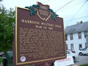
The first road through Marion County followed the Scioto Trail of the Native Americans. This 120-foot wide strip through Wyandot territory led from Lower Sandusky (Fremont) to the Greenville Treaty Line. A confederation of Ohio tribes ceded it to the United States at the Treaty of Brownsville, Michigan, in 1808. During the War of 1812, the troops of General William Henry Harrison’s Army of the Northwest traveled this road en route to Fort Meigs and the British fort at Detroit, using it to transport supplies to the army and to the chain of forts and blockhouses that protected the road. After the American victory, this area was opened for settlement by the 1817 Treaty of the Maumee Rapids, and soldiers who discovered the area while traveling the Military Road were among the first settlers. (continued on other side)
First a farming community, later a railroad crossroads in southern Hancock County, Arlington was one of the county’s earliest settlements. Gen. William Hull opened a trail into the area during the War of 1812 as he crossed Buck Run at Eagle Creek. He led his army to the Blanchard River to establish Ft. Findlay. Robert Hurd owned extensive tracts of land in the area, and his sons were the first recorded settlers, building a log cabin near this site in 1834. The rich farmland and abundant water soon attracted other settlers to the vicinity of “Hurdtown.” The name was changed to “Arlington” when the village was formally surveyed in November, 1844.
When inventor and entrepreneur Garrett Augustus Morgan sold his Traffic Signal patent to General Electric in 1923, he used the $40,000 to purchase a 121-acre farm in Huron County in 1924. Advertising “a village of our own,” Morgan established the Wakeman Country Club — one of Ohio’s early African American recreation clubs — and offered 247 lots for $60 each in “Wakeman Heights.” Located near the intersection of State Route 60 and Chenango Road, the development provided country pleasures to Blacks excluded from the Country Club lifestyle. Club membership, included in the purchase of a lot, offered fishing, hunting, swimming, and horseback riding. A restaurant, dance hall, and amphitheater provided cultural and boxing events. The club waned during World War II and no buildings from the once-thriving Wakeman Country Club remain.
Unsatisfied by the terms of the treaty that ended the French and Indian War, Ottawa chief Pontiac led a confederacy of Native American tribes in attacks against British frontier forts during 1763, a campaign known as “Pontiac’s Conspiracy.” In October 1764, Colonel Henry Bouquet led a 1500-man army into the Ohio country from Fort Pitt (present-day Pittsburgh) as a demonstration of British force and to free captives held by several tribes. Informed of possible attack, Bouquet diverted his army overland from his Tuscarawas River valley route and here deployed his forces into three lines: a group of scouts on each ridge and the main force along present Route 93. Evidence of artillery emplacements and infantry breastworks remained visible for many years.