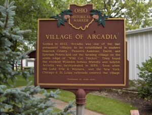
Settled in 1833, Arcadia was one of the last permanent villages to be established in eastern Hancock County. Pioneers Ambrose, David, and Ephriam Peters laid out the farming village on the south edge of “Wild Cat Thicket.” They found the resident Wyandot Indians friendly and helpful. Arcadia was incorporated in 1859. Soon after, the Lake Erie & Western, and the New York Chicago & St. Louis railroads entered the village. (Continued on other side)
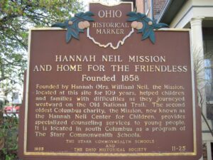
Founded by Hannah (Mrs. William) Neil, the Mission, located at this site for 109 years, helped children and families with difficulties as they journeyed westward on the Old National Trail. The second oldest Columbus charity, the Mission, now known as the Hannah Neil Center for Children, provides specialized counseling services to young people. It is located in south Columbus as a program of The Starr Commonwealth Schools.
Following the American Revolution, the new Federal government, in need of operating funds, sold millions of acres of western lands to land companies. One such company, the Ohio Company of Associates, brought settlement to Marietta in 1788. Two years later, despite warnings of Native American hostility, an association of 36 Company members moved north from Marietta to settle “Big Bottom,” a large area of level land on the east side of the Muskingum River. The settlers were acquainted with Native American warfare, but even so, built an unprotected outpost. They did not complete the blockhouse, put pickets around it, or post a sentry. On January 2, 1791, a war party of 25 Delaware and Wyandot Indians from the north attacked the unsuspecting settlers, killing nine men, one woman, and two children. War raged throughout the Ohio Country until August 1794 when the tribes were defeated at the Battle of Fallen Timbers.
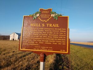
Hull’s Trail was a rough passageway through Ohio to the Canadian border, used by General William Hull’s army during the War of 1812 on its way to attack the English at Detroit. Woodsmen cleared the trail to permit the Ohio Army Militia with its artillery and baggage to travel through the unbroken wilderness. The route through Hardin County has been marked by stone columns from the old county courthouse.
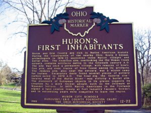
Huron and Erie County are rich in Native American history. During the construction of the nearby Ohio Route 2 bypass, archeologists in 1976-77 uncovered three Native villages and burial sites. The Anderson site, overlooking the Old Woman Creek estuary, contains artifacts dating to the fifteenth century A.D. The site was once a permanent village, with remains of bowls, fire pits, and even traces of food found among its artifacts. The Jenkins site, also near the estuary, was a winter camp for Indians. Excavators there found several pieces of pottery carbon-dated to 1470 A.D. The final dig, the Enderle site — located west of the Huron River — was strictly a burial site. The discovery of European objects in its graves suggests its creation by a more recent people, such as the Delaware or Wyandot Indians. In 1805, Native Americans in the Firelands signed a land cession treaty at Fort Industry (modern Toledo), and in succeeding years were compelled to leave the region.
S-Bridge roadside park, immediately west of New Concord on US 40
New Concord
, OH
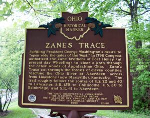
Fulfilling President George Washington’s desire to “open wide the gates of the West,” in 1796 Congress authorized the Zane brothers of Fort Henry (at present day Wheeling) to clear a path through the dense woods of Appalachian Ohio. Zane’s Trace cut through the forests of eleven counties, reaching the Ohio River at Aberdeen, across from Limestone (now Maysville), Kentucky. The trail roughly follows the routes of U.S. 22 and 40 to Lancaster, S. R. 159 to Chillicothe, U.S. 50 to Bainbridge, and S. R. 41 to Aberdeen.
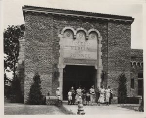
Now ranked among the country’s finest, the zoo began in 1900 with one large woodchuck in a box at Walbridge Park. After the organization of the Toledo Zoological Society, 1905-10, the zoo began its steady growth, particularly after 1923 under the leadership of Percy C. Jones. An ambitious federal construction program during the Great Depression of the 1930s provided several major structures.
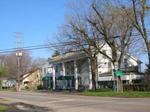
First known as the Webster House, later as the New England House, and finally as the Old Tavern, this inn has served travelers on the old Cleveland-Buffalo Road (now State Route 84) since before Ohio became a state. As traffic on the old Indian trail increased and it became a post and stage road, the two original log cabins, built in 1798 and later, were converted to this two-and-a-half story inn between 1815 and 1820. While the tavern was the scene of Civil War-era parties and dances in the second-floor ballroom, local tradition suggests it offered much more clandestine hospitality to escaping slaves as a station on the Underground Railroad. The Unionville Tavern was added to the National Register of Historical Places in 1973.