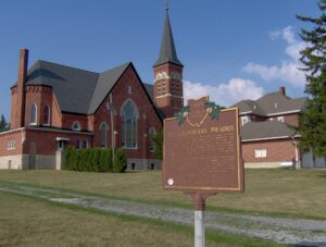
The Cranberry Prairie, southwest of this marker, is a part of Ohio’s natural history. The place was named for the cranberries that grew in a swamp here prior to drainage of the area. The Cranberry Prairie was created by centuries of peat accumulation in a late Ice Age lake that formed at the base of St. John’s Moraine. Paleo-Indian or Early Archaic peoples probably killed the elk whose skeleton was dug up here in 1981. This elk was dated at approximately 7400 B.C. By the 1860s, immigrant German farmers had begun transforming the swamp into fertile farmland. “Wild Bill” Simison, a legendary inhabitant, lived in the swamp and settlers respected him for his knowledge of the area. By the turn of the nineteenth century, Granville Township School #7, St. Francis Catholic Church, and Bertke’s Store stood at the edge of the Cranberry Prairie.
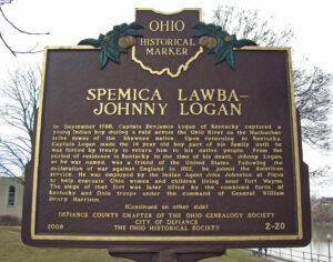
In September 1786, Captain Benjamin Logan of Kentucky captured a young Indian boy during a raid across the Ohio River on the Machachac tribe towns of the Shawnee nation. Upon returning to Kentucky, Captain Logan made the 14 year old boy part of his family until he was forced by treaty to return him to his native people. From the period of residence in Kentucky to the time of his death, Johnny Logan, as he was named, was a friend of the United States. Following the declaration of war against England in 1812, he joined the American service. He was employed by the Indian Agent John Johnston at Piqua to help evacuate Ohio women and children living near Fort Wayne. The siege of that fort was later lifted by the combined force of Kentucky and Ohio troops under the command of General William Henry Harrison. [continued on other side]
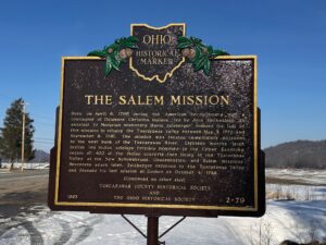
Here, on April 6, 1780 during the American Revolutionary War, a contingent of Delaware Christian Indians, led by John Heckwelder, an assistant to Moravian missionary David Zeisberger, founded the last of five missions to occupy the Tuscarawas Valley between May 3, 1772 and September 8, 1781. The mission was located immediately adjacent to the west bank of the Tuscarawas River. Eighteen months later, British led Indian soldiers forcibly removed to the Upper Sandusky region all 400 of the Indian converts then living in the Tuscarawas Valley at the New Schoenbrunn, Gnadenhutten, and Salem missions. Seventeen years later, Zeisberger returned to the Tuscarawas Valley and founded his last mission at Goshen on October 4, 1798.
Intersection of Mt. Vernon Avenue and LWR Gamiber Road.
Mount Vernon
, OH
Named for the Native Americans who first dwelled here along both sides of the Kokosing River, the Little Indian Fields is adjacent to the site of the first white settlement of Knox County. Early white inhabitants of this land were Andrew and Catherine Craig and Benjamin and John Butler. John “Appleseed” Chapman planted an apple orchard near here at the confluence of the Kokosing River and Centre Run and in 1809 bought two lots in Mount Vernon. In 1808 the Ohio Legislature created Knox County and later designated Mount Vernon as the county seat.
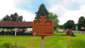
The ancient trail that passed near this spot was the major overland route entering the Ohio Country from the east through the 1700s. Also known as the Tuscarawas Path, the Great Trail was used by Native Americans, European explorers, fur traders, missionaries, military expeditions, land agents-and settlers after Ohio became a state. In January 1761, during the French and Indian War, Major Robert Rogers and thirty-eight rangers passed en route to Fort Pitt after taking Fort Detroit from the French. In 1764, during “Pontiac’s Conspiracy,” Colonel Henry Bouquet crossed here with an army of 1,500 men on his way to Goshachgunk (Coshocton), where he treated with the Delaware and freed captives. During the American Revolution, the Continental Army under General Lachlan McIntosh camped here for two days in November 1778.
As a member of the Connecticut Land Company, Judge Samuel Hinckley of North Hampton, Massachusetts purchased township 4N Range 13W of the Western Reserve in 1795 for a sum equivalent to 23 cents an acre. The township remained unsettled until Abraham Freeze was commissioned by Judge Hinckley in 1819 to survey the township into 100 plots of 160 acres each. In return for having the township, founded in 1825, named “Hinckley,” the judge gave land for two burying grounds and one-half acre for a public square. In 1919, upon the 101st anniversary of the “Great Hinckley Hunt,” where men from surrounding counties gathered on Christmas Eve to rid the township of wild animals, Judge Amos Webber spoke for the deceased Judge Hinckley: “When I last saw this country, it was a howling wilderness – by industry and frugality you and your ancestors have made these ever lasting hills and pleasant valleys blossom as the rose.”
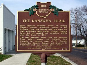
Plunging herds of buffalo seeking salt licks and grazing lands wore trails through the Ohio Country when it was an Indian no-man’s land. Later, Indians found the same trails suitable for their needs. The tawny paths were highways as well as highest ways. Indians found ridges and summits superior to valleys for trails because they were drier, windswept of snow, never clogged by flood debris and safer.
Brown County Fairgrounds off W. State Street/OH 125
Georgetown
, OH
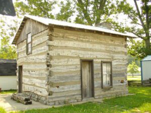
This house originally stood at Logan’s Gap, Union Township. By tradition, it was constructed in 1793 by Indian scouts William Dixon and Cornelius Washburn who became residents of Brown County. Dixon lived in this house until 1800.