

, OH
Almon Ruggles (1771-1840) came to Ohio from Connecticut in 1805 and led survey teams that divided the Firelands section of the Connecticut Western Reserve into townships. The Firelands was territory granted to Connecticut residents whose property was destroyed by the British during the Revolutionary War. Ruggles purchased a lakeshore section of this surveyed land for one dollar per acre, which is now known as Ruggles Beach. After settling permanently in Ohio in 1810, he established a farm, built gristmills, and worked for different Connecticut land proprietors. Ruggles also served in the Ohio Senate, the Ohio House, and was briefly appointed as associate judge of Huron County. Upon his death, his ashes were buried on part of his property, now known as Oak Bluff Cemetery.
, OH
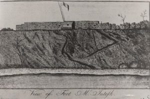
The land on which Coventry Township is situated was ceded in 1785 to the United States by the Delaware, Chippewa, Ottawa, and Wyandot tribes under the Treaty of Fort McIntosh. The area was a choice location for Native Americans, settlers, and fur traders due to the abundant bodies of water and proximity to the Portage Path, a land connection between the Tuscarawas and Cuyahoga rivers and Lake Erie. In 1788, Coventry Township was initially part of Washington County, the first county formed in the Ohio Territory. After Moses Warren finished a survey in 1797, a succession of county splits located Coventry Township in Jefferson County, Trumbull County, Portage County, and, finally, Summit County in 1840. The township originally encompassed Summit Lake and the lands south to the southern line of the Western Reserve (Green-New Franklin lines). Daniel Haines was the first resident to settle in Coventry Township in 1806.
, OH
In 1785, American Indian tribal leaders from the Chippewa, Delaware, Ottawa, and Wyandot met with representatives sent by the United States Congress to sign the controversial Treaty of Fort McIntosh. The treaty surrendered control of Native American lands in southern and eastern Ohio to the United States government. Most Indians rejected the validity of the treaty and rather than improving relations, the Treaty of Fort McIntosh only intensified the tensions that existed between the United States government and the Indian tribes. This marker signifies the eastern most portion of the American Indian territory outlined by the treaty. The Portage Path, a trail used by American Indians as a portage between the Cuyahoga and Tuscarawas rivers, became a part of this boundary line.
, OH
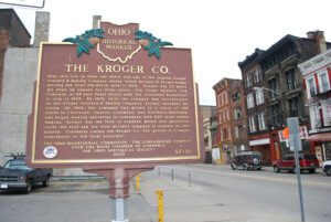
Near this site in Over-The-Rhine was one of the original Kroger Grocery & Baking Company stores, where Bernard H. Kroger began serving the Over-the-Rhine area in 1902. Kroger was 23 years old when he opened his first store, The Great Western Tea Company, at 66 East Pearl Street near the Cincinnati Riverfront in July of 1883. By 1902, when the company was incorporated as the Kroger Grocery & Baking Company, Kroger operated 40 stores. By 1908, the company had grown to a chain of 136 stores in Cincinnati, Dayton, Columbus, and Northern Kentucky, and began making deliveries to customers with 200 mule-drawn wagons. Kroger was the first to combine meats and groceries under one roof and the first grocery company to operate its own bakery. Currently called the Kroger Co., the grocer is a major contributor to the local economy.
, OH
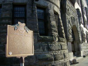
The Cleveland Grays were organized by statute in 1837 as an independent volunteer militia company. The Grays were the first company to leave Cleveland for service during the Civil War. In April 1861, they were designated Company E, 1st Ohio Volunteer Infantry (OVI). They saw action at Vienna Station and First Manassas and also served in the 84th OVI and were on duty with the 150th OVI at Fort Stephens when Confederate General Jubal Early attacked Washington in the summer of 1864. During the Spanish-American War the Grays volunteered for service and were admitted to the National Guard as the 1st Battalion of Engineers, 10th OVI. In 1916, they joined General John J. Pershing’s Punitive Expedition against Mexico. After service on the Mexican border, the Grays became part of the 1st Battalion, 148th Infantry Regiment, 37th “Buckeye” Division. (continued on other side)
, OH
Clark Lane (1823-1907), industrialist and philanthropist, was a son of John Lane (1793-1880) and Rosanah Crum (1795-1877). John came with his family to the Ohio Country when it was still part of the Northwest Territory. As a young man, Clark worked in his family’s blacksmith shop, and eventually helped found Owens, Lane & Dyer Machine Company in 1854. It built agricultural machinery, sawmills, papermaking machines, and other products, initiating Hamilton’s prominence in metals manufacturing. Lane funded the Butler County Children’s Home, an orphanage for over a century, and constructed an octagon house as his residence on Third Street. He built this library in 1866, also as an octagon, and donated it to the people of Hamilton. A 19th century admirer wrote, “The name and generous deeds of Clark Lane will never fade from the memories of a grateful people who have been recipients of his favor.”
, OH
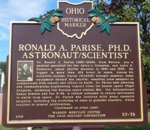
Dr. Ronald A. Parise (1951-2008), from Warren, was a payload specialist for the Astro 1, Columbia, and Astro 2, Endeavour, space shuttle missions in 1990 and 1995. He logged in more than 614 hours in space. Among his scientific studies, Parise (WA4SIR) brought amateur radio equipment aboard the shuttle, enabling crew members to communicate with schools and others on Earth. Dr. Parise held planning and communications engineering support roles for human space flight projects, including the Russian space station Mir, the International Space Station and the X-38, a vehicle intended to return astronauts to earth from space. Dr. Parise was involved with many research projects, including the evolution of stars in globular clusters, which resulted in several publications. (Continued on other side)
, OH
Mesopotamia Township, Trumbull County was a part of the Western Reserve, 3.3 million acres in Northeast Ohio claimed by Connecticut. After the Treaty of Greenville extinguished American Indian title in 1795, the state sold most of the land to the Connecticut Land Company (except for the Firelands to the west). The company’s proprietors then sold the land to settlers from Connecticut and the east and they in turn brought to the west their ideas for what a solid home should look like. (Continued on other side)