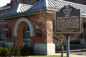
This congregation was founded in Warren November 19, 1803, by the Rev. Joseph Badger, who was serving as a missionary in the Western Reserve for the Connecticut Missionary Society of the Congregational Church. Rev. Badger was assisted at the first communion by the Rev. William Wick of Youngstown and the Rev. Samuel Tait of Mercer, Pa. The first church building on this site was constructed in 1832. The present building was dedicated in 1878.
In the 1820s a general store and grist mill were established on this site, where the famous Scioto-Sandusky Indian trail neared the Sandusky River. The settlement was first known as McNutt’s, later as Swope’s Corners. The village of Fort Seneca was surveyed January 14, 1836. Its name was derived from Gen. Harrison’s War of 1812 fort, which was located a few miles downstream.
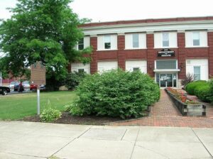
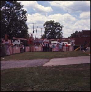
In 1910, the Ohio Electric Railway Company opened this terminal, formerly the Interurban Building, which served interurban passengers until 1937. Along with offices, it contained space for express and baggage handling, ticket windows, a newsstand, a lunch counter, and waiting rooms. Three tracks were laid at the rear of the building. At its peak, Ohio Electric radiated from Lima to Springfield, Toledo (via Ottawa), Defiance, and Fort Wayne. Its competitor, The Western Ohio Railway (“Lima Route”) connected Dayton and Toledo (via Findlay). The interurban network in and around Lima led to the creation of suburbs, linked industrial and residential areas, and promoted the creation of amusement parks and small lake resorts. With decreased passenger traffic due in part to personal automobiles and the Great Depression, the interurban and street railway era in Lima ended in 1939, 52 years after it had begun as Ohio’s first successful electric streetcar system.
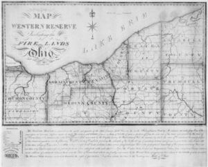
On July 4, 1796, Moses Cleaveland and his survey party landed at the mouth of Conneaut Creek on the southern shore of Lake Erie in what is today Conneaut, Ohio. The Connecticut Land Company, a private land speculation enterprise, had hired General Cleaveland as its agent to survey the Connecticut Western Reserve lands and to found a settlement along the Cuyahoga River, later named Cleveland. Group members pitched tents and erected a crude shelter to protect the provisions and survey equipment before celebrating the independence of the new country with toasts and salutes. The next day they organized into field groups to begin the historic survey of measuring the townships and ranges of the Western Reserve.
The West Liberty area, in the Mad River Valley, was the location of at least seven Shawnee Indian villages. This elevated site was the location of one of those villages. Several septs or divisions of the Shawnee nation lived in this area after being forced from their homes in southern Ohio. In 1786, together with Simon Kenton, Colonel Benjamin Logan’s army destroyed all the Shawnee villages in retaliation for the Indian raids in southern Ohio and Kentucky. Consequently, the remaining Shawnees moved to northwest Ohio near the present-day site of Maumee.
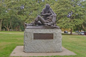
Mary Ann Ball was born in this vicinity in 1817 and began her nursing career at age 20. When the Civil War broke out in 1861, Mary at the age of 45 went to the soldiers’ aid. Ignoring rank, protocol, and allegiance, she pursued fearlessly and with inexhaustible energy her mission to care for the sick and wounded. Rebel, Union, and Negro soldiers all received the same attention. She risked enemy fire, especially through Grant’s Western Campaign and Sherman’s Georgia Campaign, to rescue suffering men, often going out at night to hunt for the fallen. When the victorious armies of the North were reviewed in Washington at the war’s end, “Mother Bickerdyke” road her faithful white horse beside the generals and colonels. Veterans along the line of march gave her the loudest cheers.
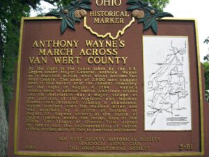
To the right is the route taken by the U.S. Legion under Major General Anthony Wayne as it marched across what would become Van Wert County. The army of 2,800 men camped west of this marker near the present cemetery on the night of August 4, 1794. Wayne’s orders were to subdue Native American tribes and his destination was a major village at the junction of the Auglaize and Maumee Rivers (now Defiance). Finding it abandoned, Wayne marched down the Maumee River and was attacked by a force of Indians on August 20. Wayne’s victory at the Battle of Fallen Timbers ended the Indian Wars of the 1790s. The Treaty of Greene Ville, signed by Wayne and the representatives of twelve tribes, opened much of Ohio to American settlement. Side one includes a map on the right hand side of the marker showing the route of Wayne’s army through the eastern third of Van Wert County.
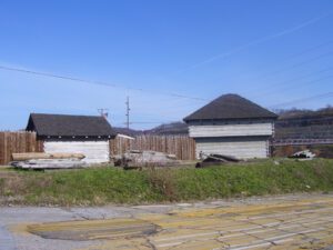
In 1787, the construction of Fort Steuben was completed by Captain John Francis Hamtramck and soldiers of the 1st American Regiment, who were sent to the frontier by the United States government to remove illegal squatters and protect government surveyors from American Indian raids. The surveyors were platting the First Seven Ranges of the Northwest Territory. The surveyed land was sold for settlement or offered to soldiers as payment for military service during the Revolutionary War. Consequently, the states of Ohio, Illinois, Indiana, Michigan, and Wisconsin were formed from the settlement of the Northwest Territory. Fort Steuben was named after Baron Frederich Wilhelm Augustus Steuben, who had served in the Revolutionary War and from which the town derived its name. Captain Hamtramck abandoned the fort in 1787 by order of Colonel Josiah Harmar, and by 1790 the remains of the fort had disappeared. Fort Steuben has been reconstructed on its original location.