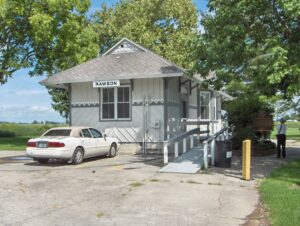
The original town plat of Rawson was filed on February 3, 1855, consisting of fifty-five lots in sections 13 and 14 of Union Township, Hancock County on the Frederick Keller and George J. Kelly farms. Several residential and business structures were built in anticipation of completion of a railroad rumored to pass from Fremont through the “Rawson” area on its way to the western boundary of Ohio. Farmers Keller and Kelly named their village Rawson after L.Q. Rawson, President of the railroad company, hoping that the name would encourage him to build through their area. Financial troubles delayed construction causing a standstill in Rawson. Seventeen years later the first locomotive arrived in Rawson, spurring new construction. At that time the railroad was called the Lake Erie and Louisville; in 1879 it was changed to the Lake Erie and Western and in 1922 became part of the Nickel Plate Railroad. (Continued on other side)
In April 1784, the Continental Congress adopted the Report of Government for the Western Territory, a broad plan drafted primarily by Thomas Jefferson for organizing the United States’ new western lands that were ceded by the states and purchased from Native Americans. One of the most far-reaching legislative acts in American history, the resulting Land Ordinance of 1785, passed on May 20th, established the public land system by which all federal land was surveyed and distributed. The Ordinance established a rectilinear survey system that divided land into townships of six miles square aligned by north-south and east-west baselines, and set aside certain lands for Revolutionary War veterans and for public schools.
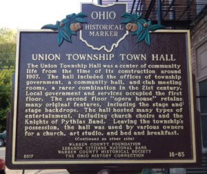
The Union Township Hall was a center of community life from the time of its construction around 1907. The hall included the offices of township government, a community hall, and club meeting rooms, a rarer combination in the 21st century. Local government and services occupied the first floor. The second floor “opera house” retains many original features, including the stage and stage backdrops. The hall hosted many types of entertainment, including church choirs and the Knights of Pythias Band. Leaving the township’s possession, the hall was used by various owners for a church, art studio, and bed and breakfast.(Continued on other side)
This area of western Hancock County is a part of the Maumee River Watershed known as “Indian Green.” Wyandot Indians chose this area for hunting and ceremonial grounds along the Blanchard River in the 1700s because it was next to the river, yet high enough to avoid frequent flooding. One-half mile east of this location is a Liberty Township cemetery. It is located upon a sand ridge once used as a burial ground by Indians, hence the name “Indian Green.”
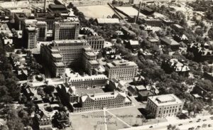
Named for the streetcar turnaround once located at Euclid Avenue and East 107th Street, University Circle is a 600-acre district that is home to many of Cleveland’s major cultural, educational, medical, and service institutions. The area was first settled in 1799 by tavernkeeper Nathaniel Doan and became known as Doan’s Corners. In 1882, Western Reserve College moved here from Hudson, followed in 1885 by the Case School of Applied Science from downtown Cleveland. These two colleges federated in 1967 to become Case Western Reserve University. (continued on other side)
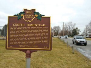
Near this site stood the former Custer Homestead of Emanuel and Maria Custer from 1856-1865. For two years it was the boyhood home of Captain Tom Custer, younger brother of famed General George Armstrong Custer. At age 16, Tom misled a recruiter in neighboring Gilead, Ohio about his age and enlisted in the Civil War. He later earned two Congressional Medals of Honor, the first person in history to do so, for capturing enemy flags at Namozine Church on April 3, 1865 and at Sailor’s Creek on April 6, 1865. His parents relocated to Monroe, Michigan during the Civil War. Tom continued serving in the Army during the Indian Wars in the West and often visited his brother Nevin in Tontogany. He, along with his brothers George and Boston, brother-in-law James Calhoun, and nephew Harry Reed, were killed at the Battle of the Little Bighorn in June 1876.
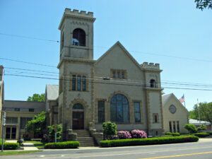
On this site, the Canfield Congregational Church, the first church in Canfield village, was built in 1822. The congregation was organized in 1804 by Joseph Badger and Thomas Robbins, both missionaries from the Connecticut Missionary Society. This was the fifth Congregational Church organized west of the Allegheny Mountains and the fourth organized on the Western Reserve. In 1853, there was a division in the church and a faction split off to form the Canfield Presbyterian Society. In 1837, an antislavery speech was given by Reverend Miller from the Poland Methodist Church. A rowdy group of outsiders protested his words and threw eggs onto the pulpit. They waited for him outside with tar and feathers, but the ladies of the church hastily escorted him out the back door to his horse and buggy, and he made a hasty and safe departure. The Bible with egg on it is displayed in the church.
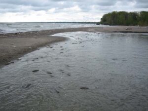
Old Woman Creek is one of the few naturally functioning estuary environments – places where chemically-distinct bodies of water meet and mix – left in the western basin of Lake Erie. This ecosystem features diverse habitats of marshlands, sand beaches, and upland forests, supporting plants and animals unique to natural coastal communities. Nearly 300 bird species (including bald eagles), 40 fish species, and hundreds of native plants have been recorded in this area. Old Woman Creek is Ohio’s only national estuarine sanctuary and became a state nature preserve in 1980.