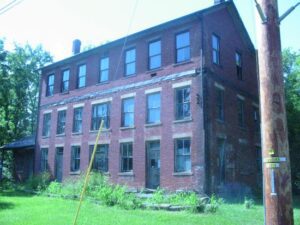
This historic inn began serving travelers on the old Portage-Columbiana stage road (now Tallmadge Road) in 1832. Two major stage lines, one from Cleveland to Wellsville (the closest Ohio River port) and the other from Cleveland to Pittsburgh, passed through Palmyra in the early 1800s. Originally a simple two-story Greek Revival-style building, it had its third story added in 1888 when it became a lodge for the Knights of Pythias fraternal organization. It served as a private residence and store for most of the 20th century. The Palmyra Center Hotel was added to the National Register of Historic Places in 1976.
SW corner of W Main Street and S Broadway Street (Public Square)
Greenville
, OH
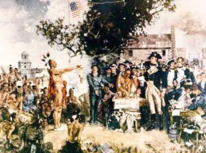
Following General Anthony Wayne’s victory at Fallen Timbers, members of the western tribes assembled at Fort Greene Ville to settle on terms of peace. Representatives of the Wyandot, Delaware, Shawnee, Ottawas, Chippewa, Ottawa, Patawatimi, Miami, Eel River, Wea, Piankeshaw, Kickapoo, and Kaskaskia signed the treaty on August 3, and agreed to cede claims to lands east of the Cuyahoga River to Fort Laurens in Tuscarawas County and south of a line running west to Fort Recovery. In return, the United States offered payment and annuities in the form of goods and ceded claim to most land north and west of the treaty line. This treaty marked the end of the Indian Wars in the Ohio Country, forsaking boundary violations by both parties, and established the official western border of the United States, opening much of Ohio for settlement.
With the signing of the Treaty of Paris in 1783, England lost the American Revolution and ceded to its former colonies land from the Atlantic Ocean to the Mississippi River. By this time, pioneer settlers had reached the eastern bank of the Ohio River, but the Ohio Country, located west and north of the river, was still considered Indian Territory. The Indian tribes desperately defended their hold on this land. On August 20, 1794, United States forces led by Major General Anthony Wayne defeated an Indian alliance at the Battle of Fallen Timbers fought near modern-day Toledo. One year later, on August 3, 1795, the largest assemblage of northwestern Indian representatives at a peace settlement signed the Treaty of Greene Ville, which effectively ceded all land south of the Greene Ville Treaty line to the Americans. The Fort Laurens site was a reference point in the Treaty line. The Ohio Country was then rapidly settled, and in 1808, Tuscarawas County was organized.
Indian Trail Caverns, first opened in 1927, is one of many caves that occur on the dolomite ridge traversed by State Route 568 in Wyandot and Hancock counties. Sheriden Cave, a karst sinkhole associated with the caverns, was discovered in 1989. It has collected a remarkable record of Ice Age animal and human activity in its sediments. Excavations have revealed remains of many extinct Late Pleistocene Epoch animals-giant beaver, stag moose, flat-headed and long-nosed peccary, and short-faced bear, among many others-that were sealed in the cave by glacial deposits more than ten thousand years ago. Paleo-Indian tools, including projectile points and scrapers, are evidence of the earliest-known human activity in this region.
Heritage Farm is a typical mid-19th century farm of the Ohio Western Reserve and has been restored and preserved. The original parcel of land consisted of 325 acres, which was purchased by David Berdan in 1818. The farmstead has been home to Abram and Sarah Berdan, William and Rachel Pitkin, George and Julia Tibbitts, and Peter and Mary Groening. The Heritage Farm Museum site consists of 4 acres with a house, privy, carriage house, corncrib, granary, equipment shed, barn, milk house, and chicken house, and was open to the public on July 1, 2000.
County Road 265 follows an old Indian trail which connected the Wyandot villages at Upper Sandusky with the Shawnee Mac-o-chee towns to the southwest. Many wigwams were pitched near this Scioto River ford during the late 18th and early 19th centuries. Soldiers (during the War of 1812), settlers, and stagecoach passengers later followed this route.
After the War of 1812, the United States Congress proposed two million acres of military bounty land for the Michigan Territory. To survey the land, the meridian had to first be established. U.S. Surveyor General Edward Tiffin created the meridian based on the western line of the Treaty of Detroit (1807). He contracted with Deputy Surveyor Benjamin Hough in April 1815 to begin the survey for $3 per mile. Taking a reading from Polaris (the North Star), Hough, Alexander Holmes, and 11 crew members surveyed the line due north from Fort Defiance. The difficult terrain they encountered temporarily halted all surveys in the territory and ultimately led to the bounty land being transferred to the Illinois and Missouri Territories.
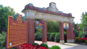
Manasseh Cutler, Rufus Putnam, Winthrop Sargeant, and Benjamin Tupper of the Ohio Company conceived Ohio University, which was encouraged by the Ordinance of 1787 and the Northwest Territorial Legislature in 1799, incorporated as the American Western University in 1802, and chartered by the Ohio State Legislature on February 18, 1804. The university is the first institution of higher learning in the Northwest Territory, second west of the Allegheny Mountains, and the first in the United States to be endowed with land by the government with proceeds used to pay for its operations-revenue from two townships was set aside to support the university. Opened on June 1, 1809, as an academy with three students, Ohio University awarded its first undergraduate degrees in 1815.