Hemlock Falls is located nearby. Two small streams cascade down the face of the massive sandstone cliff in the shade of tall hemlock trees. One of the falls drops about 60 feet and the other about 100 feet. The rock is Black Hand Sandstone deposited in the deltas along the great salt-water sea during the Mississippian Period about 350 million years ago. The cliffs were created later and were produced by erosion along the side of the valley of the ancient pre-glacial Groveport River. One large slump block, which has separated from the rock wall by weathering, may be the largest in Ohio. Plants more typical of the Appalachian Plateau and rare to Richland County can be found in this area. The ecosystem is typical of that found at the past edge of a glacier.
Clinton County was a major center of activity for the Shawnee, Miami, and Delaware Indians. Early traces and trails developed as Indians traveled from village to village; gathered flint, salt and gold; traded furs, mica, and feldspar; and hunted bear, deer, otters, raccoons, foxes, wild cats, turkeys, and other wildlife. Trails throughout the county connected to other trails and villages in Ohio such as Lower Shawnee Town (now Portsmouth), Hurricane Tom’s Town (now Piketon), Chillicothe, Old Town (near Xenia), and Miami Town (now Dayton). Major trails or traces in Clinton County included the Bullskin, Wayne, Chillicothe, Delaware, Fort Ancient, Kanawha, Kenton and Todds Fork Traces. These routes were the avenues the first white settlers followed. (continued on other side)
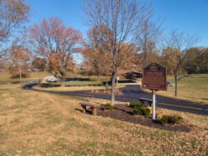
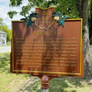
Platted in 1881 by Isaiah Custer at the junction of Zane’s Trace (1796-97) and the Cincinnati and Eastern Railway (1881). Incorporated 1886. Named after John G. Peebles, Portsmouth, Ohio, businessman. David Nixon constructed the first house in town, operated for many years as the Nixon Hotel. Annual chautauquas were conducted on grounds south of the railroad beginning in 1906 and continuing through 1917.
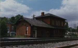
By the mid 1830s, Ohio had developed a canal system that linked Lake Erie in the north to the Ohio River in the south. Despite the success of the canals, transportation companies searched for other methods to traverse the state. They found their answer in the railroad industry, which proved to be much faster, cheaper, and more reliable than canals. Located on Lake Erie, Sandusky, Ohio was a major trading depot in the area. Plans were made to connect Sandusky to Cincinnati’s port on the Ohio River. On September 4, 1835, construction began in Sandusky on the Mad River and Lake Erie Railroad line, forming the first railroad line located entirely in Ohio. The railroad reached Tiffin by 1841 and Springfield by 1848, where it merged with the Little Miami Railroad line, connecting Lake Erie to the Ohio River.
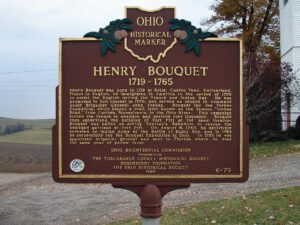
Desperately trying to protect their homeland, the Delaware Indian Nation who lived here in the Tuscarawas Valley, joined the French against the English during the French and Indian War, 1754-1763. After the French defeat, the Delawares, dissatisfied with the treaty terms, joined an Indian Confederacy to attack the English in early 1763. Known as Pontiac’s Rebellion, the uprising was lead by Ottawa chief Pontiac. In response, the English commander, General Jeffrey Amherst, ordered Colonel Henry Bouquet to mount a 1,500-man expedition to subdue the Confederacy in Ohio. The Army arrived at this location on October 13, 1764. The camp, known as Camp 14, was located in this valley between the two small streams on the side of the hill. Proceeding on to the Delaware town of modern-day Coshocton, Bouquet negotiated a surrender with the Delaware, Shawnee, and Wyandot who then relinquished over two hundred white prisoners.
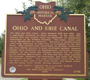
The Ohio and Erie Canal, built between 1825 and 1832, had a significant influence on Ohio’s economy. In the early 19th century Ohio was largely rural and dependent on subsistence agriculture as the primary business. The canal, which cost nearly $8,000,000 to construct, provided a transportation route from Cleveland on Lake Erie to Portsmouth on the Ohio River. Ohio farmers were encouraged to increase production and ship surplus produce to more profitable markets. Industry became more prominent as manufacturers produced building supplies for the canals and shipped products via the canal. As an internal improvement, the Ohio and Erie Canal expanded the economy, increased the population, and ended the feeling of isolation in Ohio. The canal continued south from here for about a mile until it met Water Street, now Emmitt Avenue, and ran along Water Street through Waverly.
The Sistersville Ferry is the longest continuously working mode of transportation in Monroe County, operating from 1815 to 2003. It crosses the Ohio River between Fly, Ohio, and Sistersville, West Virginia, which is the apex of the longest straight stretch on the Ohio River. This section of the river is called the “Long Reach,” which runs about twenty miles in length. At the “Long Reach,” one can see Beavertown seven and a half miles to the south, and in the other direction Sardis can be spotted five miles north. The Sistersville Ferry is located near the site George Washington encamped during a survey trip to the west on October 25, 1770.
Seba Bronson Jr. left Columbia Township in early 1810 and followed the Rocky River to an area one and a half miles north of here. He built a cabin and planted a crop and thus started what became known as the village of Hardscrabble in Liverpool Township. The village was centered around the Columbia/Grafton Road area, and the township is the oldest continuously inhabited township in Medina County. The Potawatami Indians occupied this area and camped annually along the Rocky River. For five silver dollars, they showed Seba and a partner a hidden salt springs which they sought to exploit. Other men also scrabbled to own it and Justus Warner succeeded. Seba was turned out. Warner operated the Liverpool Salt Works beginning in 1811. The first industry in the county, salt was a necessity and eagerly sought by setters in the area.