

, OH
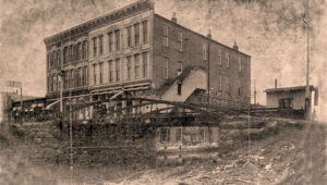
Emmitt-Greenbaum Building, 200 North Market Street, was built around 1878 by businessman and politician James Emmitt (1806-1893) to replace his 1837 wooden warehouse. The brick three-story Italianate building featured five vertical cast iron belts of simulated stone, a projecting cornice, reeded pilasters, and a “fortress-like fourteen bay front.” A covered wooden stairway on the building’s south side originally projected over the canal. Charles Louis Greenbaum (1871-1935) purchased the building in 1912 and opened his department store advertising it as “The Store with The Goods!” Over 140 years, the Emmitt-Greenbaum building was occupied by Jas. Emmitt Dry Goods, Hoffman’s, Greenbaum’s, Armbruster and Armbruster, Waverly Drugs, and the Bee Hive Tavern. A structural collapse after decades of deterioration condemned the building and the southwestern half was razed in 2021.
, OH
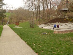
In what was called the “Freedom Summer” of 1964, more than 800 volunteers, most of them college students, gathered at the Western College for Women (now Western Campus of Miami University) to prepare for African-American voter registration in the South. Three of the volunteers – James Chaney of Mississippi, and Andrew Goodman and Michael Schwerner of New York – disappeared on June 21, 1964, in rural Mississippi mere days after leaving Oxford, Ohio. Their bodies were discovered forty-four days later, buried in an earthen dam. Ku Klux Klan members were later convicted on federal conspiracy charges. Erected in 1999, this outdoor amphitheater is a memorial to the slain activists, other volunteers, and ideals of the Freedom Summer movement.
, OH
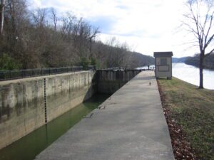
The Zanesville lock, canal, and dam were part of a series of eleven such built on the Muskingum River from Marietta to Ellis, north of Zanesville, from 1836 to 1841. The improvements made the shallow river navigable by steamboats. The State of Ohio funded the project as part of the Ohio Canal System. The locks are approximately 35 feet wide and 160 feet long. The river improvements spurred the development of industry in Zanesville, including pottery manufacture, shipbuilding, and grain milling. From Zanesville, goods could be shipped north to the Ohio Canal and Lake Erie. Products could also be sent south to Marietta and then east to Pittsburgh or southwest to New Orleans. Steamboats brought in manufactured goods, staples, mail, and entertainment. After 1880, competition from railroads caused a gradual decline in the river traffic. Today the locks remain in operation for the enjoyment of pleasure boaters.
, OH
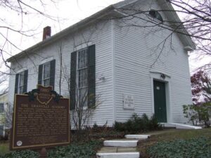
The Granville Congregational Church erected this building in 1833 for its Female Academy and a church meeting room. The school prospered and, in 1837, moved to make way for the Granville Male Academy. The Welsh Congregational Church purchased the structure in 1863 and converted its two stories into a single room with full-height windows. Welsh language services were held here for sixty years. Granville Grange #2230 met in the building from 1923 to 1973. It then became Granville Historical Society’s property and, in 1981, was listed on the National Register of Historic Places.
, OH
In 1769, Pierre-Louis de Lorimier (Peter Loramie) traveled from Canada to this vicinity to establish fur trading with the local indigenous tribes. This location is a portage between tributaries of the Ohio River and Lake Erie that eased the transport of the quantity of furs in this lucrative trade. His very profitable trading post was located just west of this marker along Loramie Creek. Lorimier’s friendship with the local Shawnee and Delaware tribes, and the British, led him to join them in efforts to curtail the movement of white settlers into the Northwest Territory. In 1782, in an attempt to halt raids along the Ohio River (many of which were formulated at Lorimier’s store), General George Rogers Clark ordered Col. Benjamin Logan to burn Lorimier’s store.
, OH
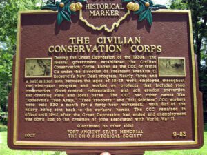
During the Great Depression of the 1930s, the federal government established the Civilian Conservation Corps, known as the CCC or triple C’s under the direction of President Franklin D. Roosevelt’s New Deal program. Nearly three and a half million men between the ages of 18-25 were employed throughout the nine-year program and worked on projects that included road construction, flood control, reforestation, and soil erosion prevention and creating state and local parks. The CCC had other names like “Roosevelt’s Tree Army,” “Tree Troopers,” and “Soil Soldiers.” CCC workers were paid $30 a month for a forty-hour workweek, with $25 of the salary being sent back to the workers’ homes. The CCC remained in effect until 1942 after the Great Depression had ended and unemployment was down due to the creation of jobs associated with World War II.
, OH
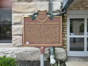
As the county seat. Port Clinton is home to the present Ottawa County Courthouse, completed on May 20, 1901 and listed on the National Register of Historic Places in 1974. Constructed in the Richardson Romanesque style, the exterior of the courthouse was built using sandstone quarried at Amherst, Ohio. Pink marble wainscoting, an ornate staircase, and stenciling enhance the interior. A copy of William Powell’s mural, “Perry’s Victory on Lake Erie,” is featured along with smaller murals depicting early county industries–farming, fishing, fruit growing, and quarrying. Memorial tablets honor veterans from the Spanish-American War and Civil War.
, OH
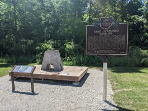
The Ohio Standard Baseline (OSB) was a geodetic baseline that provided highly accurate measurements of the earth and made possible extremely fine calibrations of surveying equipment. Several such baselines were established in Europe and South America during the mid-twentieth century, specifically designed to use a measurement device called the Vaisala Comparator, a precursor of modern laser light measurement systems. In 1953, Dr. T.J. Kukkamaki, then a professor in the Department of Geodetic Science at The Ohio State University, proposed establishing a baseline in Ohio that would be part of the worldwide efforts to accurately understand how the size and shape of the earth change over time. Built between 1965 and 1966, the resulting OSB consisted of a series of eight concrete pillars supporting mirrors and instruments, spaced along a 500 meter distance. (Continued on other side)