NE corner of S. Main Street and Zoar Road / Bayou Street
South Lebanon
, OH
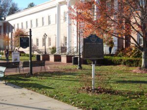
Deerfield was laid out around 1795 and in 1802 Major Benjamin Stites, his son Benjamin, Jr., and John Gano officially recorded the village’s plat. A part of the great tide of Americans moving into the Northwest Territory (and Ohio after 1803), Deerfield’s early inhabitants included Revolutionary war veteran Ephraim Kibbey as well as Andrew Lytle, Nathan Kelly, William Snook, and War of 1812 veteran David Sutton. Deerfield was so called because it was a settlement in Deerfield Township, Hamilton County in the 1790s. (Continued on other side)
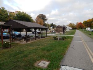
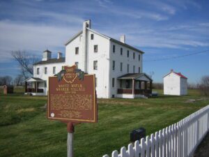
The United Society of Believers (or “Shakers,” as they are commonly known) established White Water, the last of four Ohio Shaker villages, in 1824. White Water flourished throughout the nineteenth and early twentieth centuries. At its peak during the 1850s, 150 Believers living in three semi-autonomous Shaker “families” farmed 1,300 acres of land in Crosby and adjacent Morgan townships. The Shakers were among the most successful religious societies in the United States. Belief in the equality of men and women, separation of the sexes, celibacy, communal ownership of property, and a distinctive style of worship — characterized by rhythmic movements and shaking — helped define the Shaker lifestyle. (Continued on other side)
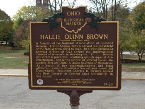
Hallie Quinn Brown (c. 1850) was born in Pittsburgh, Pennsylvania to former slaves. She and her family moved to Wilberforce, Ohio in 1870, where she received a Bachelor of Science degree from Wilberforce University in 1873. Brown taught school in the South until her appointment as professor of elocution at Wilberforce University in 1893. A gifted elocutionist and author, Brown received national and international acclaim not only for her recitals and written works, but also for her passionate belief in civil rights and African American culture. (Continued on other side)
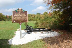
From east to west, the Chagrin Falls and Eastern Interurban Railway crossed the Muggleton Farm (now South Russell Village Park) at this location and connected the Chagrin Valley with Hiram, Garrettsville, and Middlefield. Its sister interurban, the Cleveland and Chagrin Falls Electric Railway served points west. Soon after their formation, the Everett-Moore Syndicate merged the two lines into the extensive interurban rail network, The Eastern Ohio Traction Company. The EOTC and its predecessors operated from 1899-1925, mainly moving mail, farm goods, and passengers. In 1914, the more rural line from Chagrin Falls traveling eastward became the first major interurban in the United States to cease operations. It is believed that declining use, insufficient power for the railway, and a failed line extension to Youngstown were likely factors contributing to the line’s demise.(Continued on other side)
Joseph Carter Corbin’s work in the Reconstruction-era south after the Civil War created many educational opportunities for African Americans. Corbin (1833-1911) was a professor, administrator, journalist, linguist, and musician. Born in Chillicothe, Ohio to free African American parents, he earned his bachelor’s degree and two masters’ degrees from Ohio University, in 1853, 1856, and 1889, respectively. In 1872, Corbin and his wife Mary moved to Arkansas where he served as the state superintendent of public education. In 1875, Corbin was appointed principal of Branch Normal College, which became the University of Arkansas at Pine Bluff. In 1898, he co-founded and became president of the Arkansas Teachers Association. He was also a leader in the Prince Hall Masons, an African American Masonic order. He served as a secretary and Grand Master of the lodge’s Arkansas chapter.
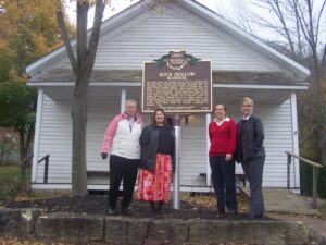
Rock Hollow School was originally built in 1877 in a wooded ravine two miles south of Ringgold, Union Township, and housed classes for fifty-seven years. The first class was held in November 1877, with John D. Davis of Ringgold teaching. Grades one through eight were taught in this one-room building, with an enrollment average of twenty to twenty-five pupils. The school closed in 1934 and sold in 1937 to Hettie Woodward, a former student and teacher at Rock Hollow School. In 1980, the heirs of the late Hettie Woodward donated the school to the Morgan County Historical Society for preservation. Fearing vandalism due to its remote location, the historical society relocated the building to its present site in Malta in 1991. The building was disassembled and rebuilt in exact original condition. Rock Hollow School was officially rededicated on November 1, 1992.
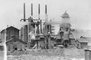
Believed to have been constructed in 1866, this facility is one of the largest of its kind in the nation. The complex of 200 ovens was erected by the Leetonia Iron and Coal Company, later known as the Cherry Valley Iron Works, to supply fuel for pig-iron producing blast furnaces that stood south of this site. The man-made “beehive” ovens were used to transform hard coal into coke. The “coking” process burnt impurities out of the coal. The end product — coke — was the best fuel source for the furnaces that were used to manufacture iron and steel. The facility discontinued operations in the early 1930s at the height of the Great Depression.
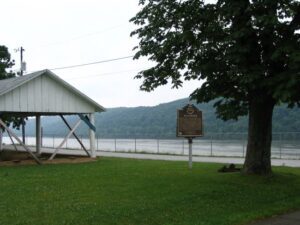
Manchester was founded in 1791 by Nathaniel Massie as a base to survey the land warrants of American Revolutionary War soldiers in the Virginia Military District. This bank of the Ohio River provided a secure site for the last civilian stockade built in Ohio. The natural protection of this fortification included marshland to the west and north and the river on the south. The nearby three islands provided a safe place for retreat in dangerous circumstances and also supplied an area to raise food in its rich bottomlands. The invention of the steam powered paddle wheel boat allowed the river to become the city’s main source of shipping and commerce in the nineteenth century. Manchester was an important port of call for provisions; the export of agricultural products; and the manufacture of goods such as pottery, furniture, and leather goods.