Evansport is named after brothers Amos and Albert G. Evans who, with Jacob Coy, had the village surveyed next to the Tiffin River on December 14, 1835. The “port” suffix in Evansport’s name reflects the river’s significance as a transportation thoroughfare. Evansport’s early growth was spurred by its mills powered by the Tiffin River. The mills provided settlers with lumber for buildings and supplied flour and cornmeal for sustenance and commerce. Settlers who poured into Williams County’s northern townships in the 1830s agitated debate about moving the county seat to a more centralized location. Evansport was platted as a possible site for the county seat. The Williams County seat was moved to Bryan in 1840 and in 1845 Defiance County was created, leaving Evansport on the Williams-Defiance county line.
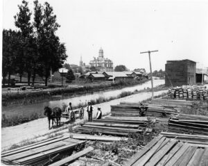
Miami & Erie Canal and Napoleon’s First Cemetery. The Miami & Erie Canal stretched approximately 250 miles from Cincinnati to Toledo. Napoleon and other towns on the Maumee River’s banks were on a slackwater section of the canal. Between 1825 and 1845, laborers constructed the canal using shovels, picks, wheelbarrows, and horse and mule-drawn carts. In Henry County, Napoleon, and elsewhere, German and Irish immigrants and area farmers did the work and were paid around 30 cents a day. As the canal brought more people and business to the area, villages such as Florida, Damascus, and Texas flourished and the county seat of Napoleon boomed. The canal and consequent growth took their tolls, however. Sickness and disease such as “ague” (malaria) and cholera spread and carried off many. Napoleon’s first cemetery was located in the vicinity of 500 East Clinton Street, near the route of the canal.
Originally called St. Clairsville and platted in 1801, Decatur was named for early 19th century naval hero Stephen Decatur. It is among the oldest villages in Brown County, which before 1817 was a part of Adams County. Among its notable early residents were Nathaniel Beasley (1774-1835), the first surveyor of Adams County, and Sarah Boone Montgomery (1763-1848), a heroine of the border wars in Kentucky. Decatur and Byrd Township supported at least four known stations on the Underground Railroad. Many area residents helped conduct escaping slaves northward to freedom.
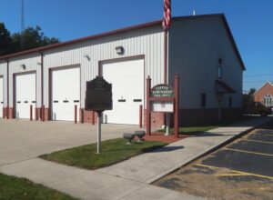
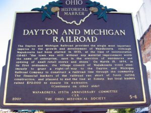
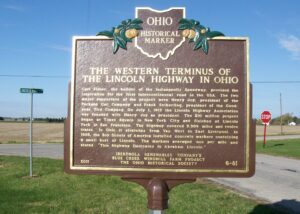
The Dayton and Michigan Railroad provided the single most important impetus to the growth and development of Wapakoneta. Although Wapakoneta had been platted in 1833, at the time of incorporation (1848), “the town was still without any material improvement worth the name of enterprise, save in the erection of residences and opening of small retail stores and shops.” On March 15, 1854, in its first ordinance, the village council of Wapakoneta voted unanimously to grant a right-of-way to the Dayton and Michigan Railroad Company to construct a railroad line through the community. The financial backers of the railroad ran short of funds during construction, and planned to end the line at Sidney, but local leaders raised $70,000 to ensure its extension. (Continued on other side)
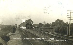
Like many nineteenth century communities in Ohio, Stryker owes its birth and early growth to the railroad industry. Stryker, named for Rome, New York, attorney and railroad executive John Stryker, was surveyed on September 19, 1853, beside the proposed Northern Indiana Railroad. For more than fifty years, “track pans” at Stryker allowed steam locomotives to take on 5,000 gallons of water while traveling at forty to fifty miles per hour, saving valuable time, “the principal enemy of railroad schedules.” On July 23, 1966, the U.S. rail speed record of 183.85 miles per hour was set through Williams County, including through Stryker. The Stryker depot was constructed in 1900 and placed on the National Register of Historic Places on August 7, 1989. (continued on other side)
This is the gravesite of Robert Nesbitt, an immigrant from Convoy, Ireland who named Convoy, Ohio after his home town. In 2010, the Convoy Community Foundation, Convoy Lions Club, Convoy Business Association, and Convoy Community Days, Inc. raised the funds to restore Nesbitt’s tombstone. A representative from Convoy, Ireland – Ray Bonar – attended the rededication ceremony on July 4, 2010. The Van Wert County Historical Society took over the care of the grave site, which is in the Sugar Ridge Cemetery. The cemetery has been under the care of the Tully Township Trustees since its foundation.
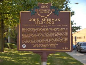
Born in Lancaster, Fairfield County, John Sherman moved to Mansfield to practice law and was elected to Congress in 1854 as one of the first Republicans. In 1861, Sherman was elected to the U.S. Senate. An authority on finance, Sherman was instrumental in shaping federal financial policy in the years following the Civil War, and President Rutherford Hayes appointed him Secretary of the Treasury in 1877. During the “Greenback” debate, he re-implemented the gold standard, stabilizing the currency during an inflationary period. Sherman returned to the Senate in 1881 and served until early 1897 when President McKinley appointed him Secretary of State; in declining health, he resigned in 1898. He died in Washington, D.C. and is interred in the Mansfield Cemetery.
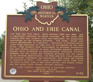
The Ohio and Erie Canal, built between 1825 and 1832, had a significant influence on Ohio’s economy. In the early 19th century Ohio was largely rural and dependent on subsistence agriculture as the primary business. The canal, which cost nearly $8,000,000 to construct, provided a transportation route from Cleveland on Lake Erie to Portsmouth on the Ohio River. Ohio farmers were encouraged to increase production and ship surplus produce to more profitable markets. Industry became more prominent as manufacturers produced building supplies for the canals and shipped products via the canal. As an internal improvement, the Ohio and Erie Canal expanded the economy, increased the population, and ended the feeling of isolation in Ohio. The canal continued south from here for about a mile until it met Water Street, now Emmitt Avenue, and ran along Water Street through Waverly.