

, OH
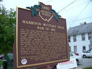
The first road through Marion County followed the Scioto Trail of the Native Americans. This 120-foot wide strip through Wyandot territory led from Lower Sandusky (Fremont) to the Greenville Treaty Line. A confederation of Ohio tribes ceded it to the United States at the Treaty of Brownsville, Michigan, in 1808. During the War of 1812, the troops of General William Henry Harrison’s Army of the Northwest traveled this road en route to Fort Meigs and the British fort at Detroit, using it to transport supplies to the army and to the chain of forts and blockhouses that protected the road. After the American victory, this area was opened for settlement by the 1817 Treaty of the Maumee Rapids, and soldiers who discovered the area while traveling the Military Road were among the first settlers. (continued on other side)
, OH
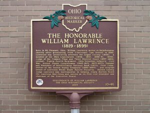
Born in Mt. Pleasant, Ohio, William Lawrence moved to Bellefontaine shortly after graduating from Cincinnati Law School in 1840. Lawrence was prosecuting attorney for Logan County (1845); a member of the Ohio Legislature (1846, 1847, 1849-51, 1854); Judge of the Common Pleas and Third District Court (1857-1864); colonel, Eighty-fourth Regiment, Ohio Volunteer Infantry, Civil War; United States Congressman (1865-1871, 1873-1877); Founder and President of Bellefontaine National Bank (1871); First Comptroller of the United States Treasury (1880-1885); and original owner of Lawrence Woods State Nature Preserve, Hardin County. Judge Lawrence was instrumental in helping Clara Barton found the American Red Cross and served as its first vice president and chairman of the Executive Board.
, OH
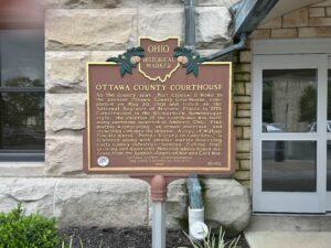
As the county seat. Port Clinton is home to the present Ottawa County Courthouse, completed on May 20, 1901 and listed on the National Register of Historic Places in 1974. Constructed in the Richardson Romanesque style, the exterior of the courthouse was built using sandstone quarried at Amherst, Ohio. Pink marble wainscoting, an ornate staircase, and stenciling enhance the interior. A copy of William Powell’s mural, “Perry’s Victory on Lake Erie,” is featured along with smaller murals depicting early county industries–farming, fishing, fruit growing, and quarrying. Memorial tablets honor veterans from the Spanish-American War and Civil War.
, OH
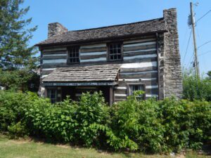
James Sr. and Rebecca (Junkin) Galloway moved with their family to Greene County from Kentucky in 1798, constructing their first home, a small log cabin. Galloway built the present structure around 1799 near the bend in the Little Miami River near what is now Goes Station on U.S. 68. In 1936, the Greene County Historical Society moved the home to the corner of Second and Monroe streets and then to the present site in 1965. The 1974 Xenia Tornado caused serious damage to the building, which has been restored and maintained by the historical society. James Sr. served as a hunter during the American Revolution, procuring game for the army, and while in Ohio, was the first treasurer of Greene County. His son James Jr. served as the first County Surveyor.
, OH
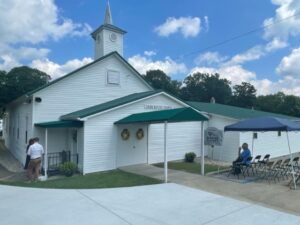
The Burton Congregational Church was organized in 1808 and met in several nearby locations before this present building was erected in 1836 at a cost of $4,000. It was originally located within the park directly opposite where it stands today, but was moved to its present location in 1850. The steeple, rising 104 feet from the ground, crowned the roof in 1875. The church building was frequently used as a public hall and for many years was also used as the main hall for the Agricultural Fair, the forerunner of the Great Geauga County Fair. A former architect referred to the church as “Steamboat Gothic” because of its unusual appearance, but to its membership and friends it is just a beautiful place to worship God.
, OH
Union Baptist Church, established in 1819, is one of Ohio’s early Black churches. Its pastor and members were active on the Underground Railroad from that early date. Between the 1840s-1860s Black churches along the route to and from nearby Poke Patch assisted over 200 escaped slaves. Members met in their homes until able to obtain a log cabin (circa 1879) on a Blackfork farm. In 1919, a larger church was built on land given by The Cambria Clay Products Company. The adjacent cemetery has over fifty veterans from the Civil, Spanish American, both World, Korean, and Vietnam wars. Donald Russell Long, laid to rest in 1966, received a posthumous Congressional Medal of Honor. Union Baptist Church, the historic foundation of the Poke Patch-Blackfork community, celebrates an annual Church Anniversary to honor its legacy.
, OH
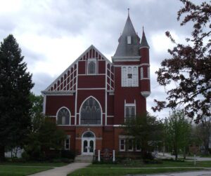
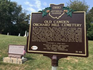
In 1817, Revolutionary War veteran and Camden co-founder James Moore Sr. and his wife, Mary, deeded a plot to the trustees of the Methodist Episcopal Church (MEC) to erect a place of worship. Although a church was not built until 1825, the earliest burial stone recovered on the plot was that of five-year-old Simon P. Zimmerman, dated 1818. Many subsequently interred were victims of the cholera epidemic of 1849. Felix and Rachel Marsh, in 1852, sold an adjacent one-acre plot to the MEC trustees “for a graveyard.” The expanded cemetery became known as Orchard Hill Cemetery due to the nearby fruit orchards. Prominent citizens of early Camden as well as veterans of American conflicts from the Revolution through the Civil War are buried in the cemetery. (Continued on the other side)
, OH
The most notable feature of Mantua Center is the “Village Green,” which harkens back to the New England heritage of Mantua Center’s early settlers. The Green sets upon land donated by Hezekiah Nooney Sr. and was important to both the social and commercial interests of the town. The businesses located here were a furniture and cabinet maker’s shop, harness shop, blacksmith shop, post office, tannery, ashery, dry goods store, and distillery. The Methodist Episcopal Church, now the Mantua Civic Center, stands at the southwest corner of the green. Eastlawn cemetery, with a burial that dates to 1816, sits along the south border. The cemetery serves as the final resting place for soldiers of several wars, including the American Revolution, as well as many other early citizens. In 1835 Horace Sizer constructed the stone wall around the cemetery adjacent to Mantua Center Road. [continued on other side]