Fort Amanda State Memorial, OH 198, 1/4 mile S of Ft. Amanda Road, Lima
Lima
, OH
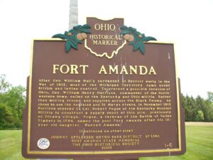
After Gen. William Hull’s surrender at Detroit early in the War of 1812, most of the Michigan Territory came under British and Indian control. To prevent a possible invasion of Ohio, Gen. William Henry Harrison, commander of the Northwestern Army, called up the Kentucky and Ohio militia. Rather than moving troops and supplies across the Black Swamp, he chose to use the Auglaize and St. Marys rivers. In November 1812 Harrison ordered Lt. Col. Robert Pogue of the Kentucky Mounted Militia to construct a supply depot at this site, previously an Ottawa village. Pogue, a veteran of the Battle of Fallen Timbers in 1794, named the post Fort Amanda after his 12-year-old daughter, Hannah Amanda. (continued on other side)
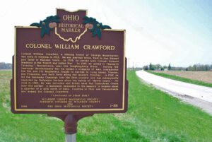
Colonel William Crawford, a lifelong friend of George Washington, was born in Virginia in 1722. He was married twice, first to Ann Stewart and later to Hannah Vance. In 1755, he served with Colonel Edward Braddock in the French and Indian war. In 1767, he moved to “Stewart’s Crossing,” Pennsylvania, near the Youghiogheny River. During the Revolutionary War he raised a company of men, commanded the 5th and 7th Regiments, fought in battles in Long Island, Trenton, and Princeton, and built forts along the western frontier. In 1782, he led the Sandusky Campaign into the Ohio country and was subsequently captured by Delaware Indians after the battle of “Battle Island.” On June 11, 1782, he was tortured and killed near the Tymochtee Creek near this marker. A monument dedicated to his memory is located about a quarter mile north of here. Counties in Ohio and Pennsylvania are named for Colonel Crawford.
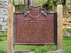
One of the 69 charcoal iron furnaces in the famous Hanging Rock Iron Region. Extending more than 100 miles from Logan, Ohio to Mt. Savage, Kentucky this area contained all materials necessary to produce high grade iron. The industry flourished for over 50 years in mid-nineteenth century during which time the area was one of the leading iron producing centers of the world. The charcoal iron industry was responsible for the rapid development of southern Ohio and the romance of the Hanging Rock Iron Region forms a brilliant chapter in the industrial history of the Buckeye State.
You are standing on the famous portage, carrying-place between the Cuyahoga and Tuscarawas rivers. The two streams and the portage across the watershed formed an early route between Lake Erie and the Ohio River. First the Indians, then French and English traders and trappers, and finally American settlers and travelers carried their canoes and packs across this narrow strip of land in passing, by way of the rivers, between northern and southern Ohio. The portage was a part of the defined boundaries in the treaties with the Indians made at Fort McIntosh (1785), Fort Harmar (1789), and Green Ville (1795). Use of the portage was discontinued in 1827 when the Ohio and Erie Canal was built along the old trail. Today, modern Akron streets–Portage Path and Manchester Road–follow the approximate route of the original portage.
One of 69 charcoal iron furnaces in the famous Hanging Rock Iron Region. Extending more than 100 miles, from Logan, Ohio, to Mt. Savage, Kentucky, this area contained all materials necessary to produce high grade iron. The industry flourished for over fifty years in the mid-nineteenth century, during which time the area was one of the leading iron producing centers of the world. The charcoal iron industry was an important factor in the development of southern Ohio, and the romance of the Hanging Rock Iron Region forms a brilliant chapter in the industrial history of the Buckeye State.
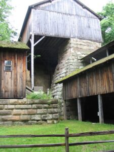
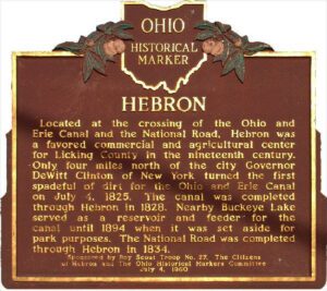
Located at the crossing of the Ohio and Erie Canal and the National Road, Hebron was a favored commercial and agricultural center for Licking County in the nineteenth century. Only four miles north of the city Governor DeWitt Clinton of New York turned the first spadeful of dirt for the Ohio and Erie canal on July 4, 1825. The canal was completed through Hebron in 1828. Nearby Buckeye Lake served as a reservoir and feeder for the canal until 1894 when it was set aside for park purposes. The National Road was completed through Hebron in 1834.
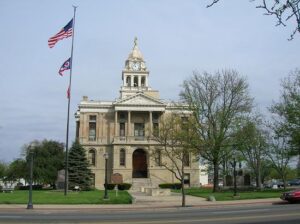
Opened on May 1, 1885, this is the third Fayette County Court House building. Ohio artist Archibald Willard, who is best known for the patriotic painting, “The Spirit of ’76,” was commissioned by the firm Cooks Brothers to do painting and fresco work for the interior walls of the courthouse. Willard did not sign his work and the artist’s identity remained a mystery for nearly 75 years until confirmation was made in August 1956. The artist’s name was cleverly disguised in the delivery address of the letter in “The Spirit of the U.S. Mail” mural. The other primary murals, “Spirit of Electricity” and “Spirit of the Telegraph,” adorn the third floor corridor.
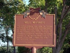
The earliest highway signs along the National Road (Route 40) in Ohio were milestones located at one-mile intervals along the north side of the roadway. Each stone indicated the distance to Cumberland, Maryland, the eastern terminus of the National Road, and to the nearest cities and villages for both east and westbound travelers.