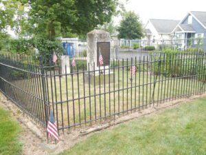
The first War of 1812 battle on Ohio soil was fought here when about 60 exhausted citizen soldiers were ambushed by about 130 Indians on September 29. Twenty men held the Indians at bay from a cabin while the main body escaped by boat to Cedar Point. Two days later the defenders were rescued. Forty Indians including several chiefs and 8 Americans were killed in the skirmish, neither a victory nor a defeat for either side.
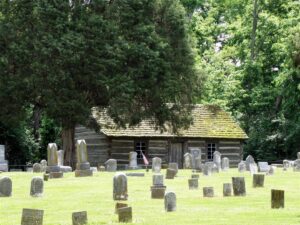
To Commemorate the first church erected in Union Township, Miami County, Ohio, this log replica was constructed in 1976 by the Union Township 4-H Clubs and the West Milton area Camp Fire Girls. The Laura Lions Club established this historic marker which stands on the site of the West Branch Quaker Burial Grounds near the location of the original church.
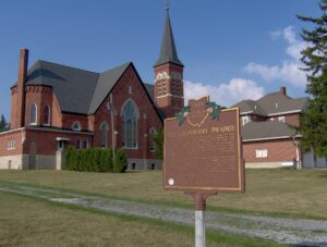
The Cranberry Prairie, southwest of this marker, is a part of Ohio’s natural history. The place was named for the cranberries that grew in a swamp here prior to drainage of the area. The Cranberry Prairie was created by centuries of peat accumulation in a late Ice Age lake that formed at the base of St. John’s Moraine. Paleo-Indian or Early Archaic peoples probably killed the elk whose skeleton was dug up here in 1981. This elk was dated at approximately 7400 B.C. By the 1860s, immigrant German farmers had begun transforming the swamp into fertile farmland. “Wild Bill” Simison, a legendary inhabitant, lived in the swamp and settlers respected him for his knowledge of the area. By the turn of the nineteenth century, Granville Township School #7, St. Francis Catholic Church, and Bertke’s Store stood at the edge of the Cranberry Prairie.
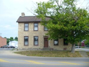
The Smith Tannery is the oldest original structure remaining in Greenfield. Built in 1821 by Revolutionary War veteran William Smith and his son Samuel, the tannery became a noted station on the fabled “Underground Railroad.” The structure, which also served as the family residence, was the birthplace of Dr. Samuel M. Smith, Surgeon General of Ohio during the Civil War, and Dr. William R. Smith, who personally notified Abraham Lincoln of his nomination to the presidency in 1864. The Smiths were active members of the Abolition Society of Paint Valley, which was established in 1833 in Greenfield and reorganized in 1836 as the Greenfield Anti-Slavery Society. In 1844, the Society assisted the efforts of Frederick Douglass, one of the nation’s leading abolitionists. The Society provided an important junction on the Underground Railroad, assisting many fugitive slaves to gain freedom, including, it is said, Eliza Jane Harris of Uncle Tom’s Cabin fame. The Smith Tannery was named to the National Register of Historic Places in 1978.
A group of Freemasons, inspired by the concepts of a new country, of Freedom with Responsibility, Brotherly Love, and Truth, formed Harmony Lodge near this site in 1809, the first Masonic lodge in western Ohio. Meetings were held in the log court house, located on Lot 174, East Court Street, and also in Dayton and Springfield.
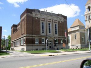
This building was a center of community life from the time of its construction in 1886 to the late 1930s. Once common, such combinations of governmental offices and commercial and entertainment space are today rare. The second floor opera house retains many original features, including stage backdrops, dressing rooms, and seats. Vaudeville, theater companies, and entertainment of all kinds were hosted here and many performers signed the backstage walls: Buffalo Bill dated his signature October 28, 1888. Along with village offices, first floor tenants have included the Vermillion Township Trustees, the Eddie Stover Hat Shop, and the F.L. Smith Watch Repair and Jewelry Store. Hayesville’s citizens approved the hall’s construction on April 18, 1884 by a vote of 100 to 13. Contractor Samuel Craig completed the building two years later at a cost of $4,852.20. Located on the Lincoln Highway, this building was listed on the National Register of Historic Places in 1976.
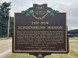
Here, on April 10, 1779 during the Revolutionary War, David Zeisberger founded one of the five Delaware Christian missions to occupy the Tuscarawas Valley between May 3, 1772 and September 8, 1781. Living at the Lichtenau mission near the Delaware capital of Goschachgunk (presently Coshocton, Ohio), Zeisberger feared that the Delaware nation was about to break their neutrality and join the British led Indians. Accordingly, he decided to disperse his Christian congregation and move his converts thirty-five miles up river to a place of safety in this large alluvial plain adjacent to the Tuscarawas River.
With a population of 475 residents, the Beallsville community gained the unfortunate distinction of having suffered the highest known per-capita casualty rate during the Vietnam War. Six Beallsville men, all under the age of 21, were killed in action in Vietnam between 1966 and 1971, a profound tragedy for this close-knit community. In 1969 Beallsville citizens worked with congressional representatives to prevent further loss of life, to no avail. Five other Monroe County men lost their lives in the conflict as well, magnifying the loss for one of Ohio’s least-populated counties. (continued on other side)