

, OH
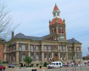
Established as the county seat of Pickaway County in 1810, Circleville derives its name from the circular portion of a large Hopewell-era earthwork upon which it was built. The Circleville earthworks, described in 1772 by Rev. David Jones for a Boston magazine, comprised an 1,100 foot diameter circle connected to a 900 foot square. Town director Daniel Dreisbach platted the town directly atop the earthworks, integrating the town plan into the prehistoric landscape. An octagonal courthouse stood directly in the center.
, OH
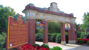
Manasseh Cutler, Rufus Putnam, Winthrop Sargeant, and Benjamin Tupper of the Ohio Company conceived Ohio University, which was encouraged by the Ordinance of 1787 and the Northwest Territorial Legislature in 1799, incorporated as the American Western University in 1802, and chartered by the Ohio State Legislature on February 18, 1804. The university is the first institution of higher learning in the Northwest Territory, second west of the Allegheny Mountains, and the first in the United States to be endowed with land by the government with proceeds used to pay for its operations-revenue from two townships was set aside to support the university. Opened on June 1, 1809, as an academy with three students, Ohio University awarded its first undergraduate degrees in 1815.
, OH
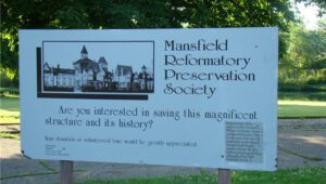
Designed by architect Levi T. Scofield, the Ohio State Reformatory opened its doors in 1896 as a facility to rehabilitate young male offenders through hard work and education. A self-sufficient institution with its own power plant and working farm, the reformatory produced goods in its workshops for other state institutions and provided opportunities for inmates to learn trades. As social attitudes towards crime hardened in the mid-twentieth century, it became a maximum-security facility. The six-tier East Cell Block is the largest known structure of its kind. Considered substandard by the 1970s, The Ohio State Reformatory closed in 1990. It has served since as a setting for several major motion pictures. This Mansfield landmark was added to the National Register of Historic Places in 1983.
, OH
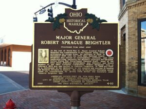
Robert Sprague Beightler was born in 1892 in Marysville. A graduate of Marysville High School, he began his career as a soldier in 1911, when he enlisted as a private in Marysville’s guard unit, Company E, Fourth Ohio Infantry Regiment. He served in Mexico from 1916-1917, World War I from 1917-1919, and World War II from 1940-1945. From his stint with the Ohio Infantry, he rose in rank to command the famous 37th Ohio National Guard Buckeye Division as Major General during WWII. Beightler was one of the most successful National Guard Generals and the only National Guard General to lead his troops through both training and combat in WWII. He was with his troops through 700 days of fighting in the South Pacific Theater. Fighting occurred on Bougainville Island and in the islands of New Georgia and the Philippines. (Continued on other side)
, OH
Native Americans inhabited and used much of the land in the Ohio valley as hunting grounds. As American settlers pushed west, conflicts resulted and attempts at peaceful settlement failed. Under political pressure, President George Washington resolved to subdue Indian resistance to American expansion in the Ohio country and appointed General Arthur St. Clair to lead the expedition. St. Clair’s troops camped on the Wabash River (just east of the Ohio-Indiana state line) after an exhausting two-month trek. The ill-prepared soldiers were no match for the forces of Miami, Shawnee, and Delaware Indians who attacked them at dawn of November 4, 1791. By the day’s end, warriors led by Little Turtle and Blue Jacket had killed or wounded nearly three-quarters of the American force-the worst-ever defeat of the U.S. Army by Native Americans in a single battle.
, OH
With the signing of the Treaty of Paris in 1783, England lost the American Revolution and ceded to its former colonies land from the Atlantic Ocean to the Mississippi River. By this time, pioneer settlers had reached the eastern bank of the Ohio River, but the Ohio Country, located west and north of the river, was still considered Indian Territory. The Indian tribes desperately defended their hold on this land. On August 20, 1794, United States forces led by Major General Anthony Wayne defeated an Indian alliance at the Battle of Fallen Timbers fought near modern-day Toledo. One year later, on August 3, 1795, the largest assemblage of northwestern Indian representatives at a peace settlement signed the Treaty of Greene Ville, which effectively ceded all land south of the Greene Ville Treaty line to the Americans. The Fort Laurens site was a reference point in the Treaty line. The Ohio Country was then rapidly settled, and in 1808, Tuscarawas County was organized.
, OH
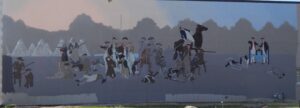
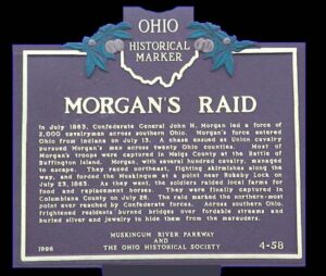
In July 1863, Confederate General John H. Morgan led a force of 2,000 cavalrymen across southern Ohio. Morgan’s force entered Ohio from Indiana on July 13. A chase ensued as Union cavalry pursued Morgan’s men across twenty Ohio counties. Most of Morgan’s troops were captured in Meigs County at the Battle of Buffington Island. Morgan, with several hundred cavalry, managed to escape. They raced northeast, fighting skirmishes along the way, and forded the Muskingum at a point near Rokeby Lock on July 23, 1863. As they went, the soldiers raided local farms for food and replacement horses. They were finally captured in Columbiana County on July 26. The raid marked the northern-most point ever reached by Confederate forces. Across southern Ohio, frightened residents burned bridges over fordable streams and buried silver and jewelry to hide them from the marauders.
, OH
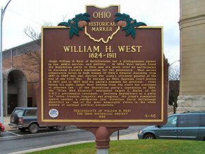
Judge William H. West of Bellefontaine led a distinguished career in law, public service, and politics. In 1854 West helped found the Republican party in Ohio and six years later he participated in Abraham Lincoln’s nomination for the presidency. West served consecutive terms in both houses of Ohio’s General Assembly from 1857 to 1865 and was elected the state’s attorney general at the end of the Civil War. He became an Ohio Supreme Court justice in 1871 and in 1877 was his party’s nominee for governor. After losing his sight, Judge West retired from the court but continued to practice law. At the Republican party’s convention in 1884, the “Blind Man Eloquent” nominated James G. Blaine as the G.O.P.’s presidential candidate. Defining Republicans as a party for “union, freedom, humanity, and progress,” the judge’s nomination speech sparked a celebration that historian David McCullough described as “one of the most memorable events in the whole history of national political conventions.”