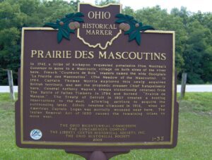
In 1742, a tribe of Kickapoo requested permission from Montreal’s Governor to move to a Mascoutin village on both sides of the river here. French “Coureurs de Bois” traders named the wide floodplain “La Prairie des Mascoutins” (The Meadow of the Mascoutin). In 1764, Captain Thomas Morris explored this newly acquired British territory, and met the prophetic dreamer Chief Katapelleecy here. General Anthony Wayne’s troops victoriously returned from The Battle of Fallen Timbers in 1794 and burned “Prairie de Masque.” The Treaty of Detroit in 1807 created a hunting reservation to the east, allowing settlers to acquire the surrounding lands. Ethnic tensions climaxed in 1812, when an American Captain Logan was mortally wounded near here. The Indian Removal Act of 1830 caused the remaining tribes to move west.
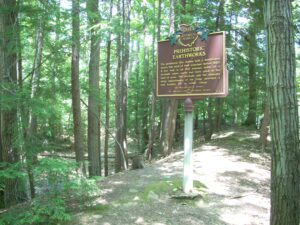
The prehistoric Erie Indians built a fortification across this neck of land sometime before 1650. A low wall is all that remains today of a stockade where earth had been piled at the base of posts. The stockade and the naturally steep embankments of the ridge provided a safe location for an Indian village.
The Northwest Ordinance of 1787 defined the boundary of the northern and southern tier of states to be carved out of the Northwest Territory, as a line drawn east from the southernmost tip of Lake Michigan until it intersects Lake Erie. Controversy over the exact location of that line led to the 1834-1837 boundary dispute between the State of Ohio and Michigan Territory. Passions ran high as everyone on both sides of the boundary knew that a great port city (Toledo) would emerge in the disputed territory. President Andrew Jackson settled the dispute in 1836 when he signed an act that recognized the current border between Ohio and Michigan, giving Michigan 9,000 square miles of Upper Peninsula land and awarding the disputed strip of approximately 470 square miles to Ohio. Michigan then joined the nation as a state the following year.
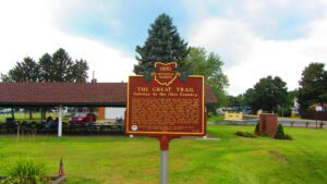
The ancient trail that passed near this spot was the major overland route entering the Ohio Country from the east through the 1700s. Also known as the Tuscarawas Path, the Great Trail was used by Native Americans, European explorers, fur traders, missionaries, military expeditions, land agents-and settlers after Ohio became a state. In January 1761, during the French and Indian War, Major Robert Rogers and thirty-eight rangers passed en route to Fort Pitt after taking Fort Detroit from the French. In 1764, during “Pontiac’s Conspiracy,” Colonel Henry Bouquet crossed here with an army of 1,500 men on his way to Goshachgunk (Coshocton), where he treated with the Delaware and freed captives. During the American Revolution, the Continental Army under General Lachlan McIntosh camped here for two days in November 1778.
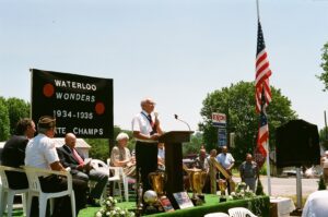
Waterloo was home to the legendary Waterloo Wonders. Coach Magellan Hariston and his Wonder Five captured consecutive Ohio state high school Class B basketball championships in 1934 & 1935, winning 94 out of 97 games, and defeating many Class A and college teams. The 91st Ohio House of Representatives honored the Waterloo Wonders with a resolution following their second Class B State Championship win. The Wonders, known for their colorful passing show, entertained fans with their scoring ability, defense, trick passes, and hardwood antics. Hailing from a small village with a school male enrollment of only 26, the Waterloo Wonders were considered one of the greatest basketball teams ever assembled on the Ohio high school athletic scene. After high school, four of the Wonder Five played professionally as the Waterloo Wonders, ranking among the best basketball squads in the country.
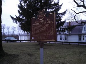
In April 1830 four Dominican sisters from St. Catherine’s, Kentucky, founded St. Mary’s Academy, the first Catholic school in Perry County. Bishop Edward Fenwick, first Bishop of Ohio, donated a small brick house and attached building situated on an acre of land for the school’s use. Classes began with forty students. The following year the sisters built a three-story structure with a dormitory for boarders; by the end of the Civil War, enrollment had increased to 134 students, and St. Mary’s gained recognition as one of the finest schools in Ohio. An 1866 fire destroyed the academy, and in 1885 the Dominican sisters reestablished the academy as a parish school. The present Holy Trinity School building dates to 1968.
In 1910, the Ohio Electric Railway Company opened this terminal, formerly the Interurban Building, which served interurban passengers until 1937. Along with offices, it contained space for express and baggage handling, ticket windows, a newsstand, a lunch counter, and waiting rooms. Three tracks were laid at the rear of the building. At its peak, Ohio Electric radiated from Lima to Springfield, Toledo (via Ottawa), Defiance, and Fort Wayne. Its competitor, The Western Ohio Railway (“Lima Route”) connected Dayton and Toledo (via Findlay). The interurban network in and around Lima led to the creation of suburbs, linked industrial and residential areas, and promoted the creation of amusement parks and small lake resorts. With decreased passenger traffic due in part to personal automobiles and the Great Depression, the interurban and street railway era in Lima ended in 1939, 52 years after it had begun as Ohio’s first successful electric streetcar system.
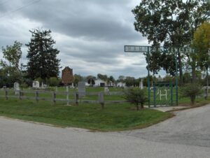
On September 8, 1803, the year that Ohio became a state, the Associate Judges of Franklin County ordered that a road be constructed “leading from the Public Square in Franklinton to Springfield, Greene County.” This road came to be known as The Old State Road or Ludlow’s Road. On this spot in the summer of 1822, the Village of New Hampton was laid out, the road being Main Street of the village. New Hampton was the forerunner of West Jefferson. It fell into oblivion eight to nine years later when West Jefferson was developed along the National Road. All that remains of New Hampton is the cemetery and this part of the road.