

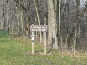
, OH
The Village of Tadmor is significant as being the location of one of the most important centers of transportation in early Ohio history. As early as 1809, keelboats were poled up river from Dayton to load and unload freight in the village. By 1837, the Miami and Erie Canal had reached Tadmor, connecting it to the Ohio River in the south and Lake Erie in the north. In the 1830s, the National Road was constructed through Tadmor, connecting it to points east and west. In 1851, the Dayton & Michigan Railroad established freight and passenger service to the growing town. Residents hoped that Tadmor’s strategic location would help it prosper, however, successive flooding on the Great Miami River stifled growth. Tadmor was finally abandoned when a dam constructed by the Miami Conservancy District in 1922 to retain water during flooding made the site uninhabitable.
, OH
When inventor and entrepreneur Garrett Augustus Morgan sold his Traffic Signal patent to General Electric in 1923, he used the $40,000 to purchase a 121-acre farm in Huron County in 1924. Advertising “a village of our own,” Morgan established the Wakeman Country Club — one of Ohio’s early African American recreation clubs — and offered 247 lots for $60 each in “Wakeman Heights.” Located near the intersection of State Route 60 and Chenango Road, the development provided country pleasures to Blacks excluded from the Country Club lifestyle. Club membership, included in the purchase of a lot, offered fishing, hunting, swimming, and horseback riding. A restaurant, dance hall, and amphitheater provided cultural and boxing events. The club waned during World War II and no buildings from the once-thriving Wakeman Country Club remain.
, OH
Through the terms of his will, British absentee landowner Samuel Gist (c. 1723-1815) freed his 350 Virginia slaves and provided funds for their relocation, the purchase of land, and the establishment of schools and homes. The executors of Gist’s will acquired over 2,000 acres of land in Ohio, including two large tracts in Scott and Eagle townships in Brown County in 1819. In 1831 and 1835, an agent of the Gist estate purchased 207 acres in Highland County and divided the acreage into thirty-one lots. This Gist settlement in Eagle Township was the first to be purchased and settled. It was recorded at Brown County on August 4, 1819 as 1197 acres of land divided among “150 Negroes who were emancipated by the will of Samuel Gist”. In 2009, descendants of the freed Gist slaves still inhabited part of the original settlement.
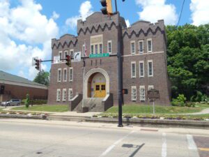
, OH
In the first years of the twentieth century, Athens’ citizens formed a new National Guard company. The guardsmen initially held drill at the Campbell Block on Court Street, but soon the Athens Commercial Club began advocating for an armory from the Ohio National Guard. In 1912, the Armory Board approved the request. Plans were drawn up for the armory and the Guard purchased land from the Athens Brick Company at the foot of Shale Hill. Construction began in the spring of 1915 and the Armory opened in December. In March of 1917, the city held a dedication ceremony and parade. Before World War I, the Athens Armory housed Company L and the Machine Gun Company, both part of the 7th Infantry Regiment, Ohio National Guard. (Continued on other side)
, OH
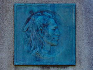
Tah-gah-jute, the Mingo chief named Logan, was a native of Pennsylvania. Logan moved to Ohio in 1770, and settled at the Pickaway Plains. Logan and his father, Shikellimus, had long supported friendships between Native Americans and white men; however, in the spring of 1774, his tribesmen and family were murdered at Yellow Creek, along the Ohio River. Once an advocate of peace, Logan went on the warpath and raided frontier settlements. These and similar raids along the Ohio frontier precipitated Lord Dunmore’s War in October 1774. After the Shawnees and their allies were defeated at Point Pleasant, Virginia governor Lord Dunmore marched up the Hocking River to the Pickaway Plains. Dunmore asked his interpreter, Colonel John Gibson, to assist in negotiations with Cornstalk and other Indian leaders, including Logan. Logan declined to attend the conference, but spoke to Gibson about his anger and betrayal.
, OH
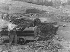
Agriculture dominated the economy of southeastern Ohio’s Morgan County until the 1940s when harvests dwindled, the population declined, and land values dropped. Surface mining the area’s rich underground coal deposits replaced agriculture as the major industry and revitalized the declining local economy. As the nation’s demand for electricity grew over the next half-century, so did the demand for coal as fuel for nearby power generation plants. During mining’s heyday in the 1960s to the late 1980s, American Electric Power’s former Central Ohio Coal Company subsidiary employed nearly 1,000 people. Nearby communities-such as Cumberland, Caldwell and Chandlersville-thrived. As time passed, however, the robust coal industry was hit hard by environmental regulations that reduced the market for the area’s high-sulfur coal. In turn, mine work forces shrank considerably and local businesses closed. (continued on other side)
, OH
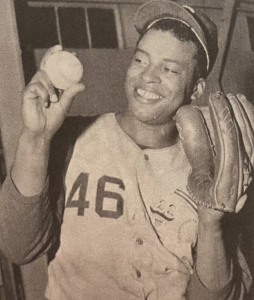
Ulysses Brooks Lawrence was born in Springfield on January 30, 1925. Nicknamed “The Bull,” he broke numerous color barriers throughout his baseball career. In 1976, Lawrence was the first Black player inducted into the Cincinnati Reds Hall of Fame. An all-around athlete at Springfield High School, Lawrence lettered in basketball, track, and football (the school’s first Black starting quarterback). After graduation in 1943, he was drafted into the U.S. Army and earned a Bronze Star in Guam during World War II. Lawrence enrolled at Ohio’s Miami University, becoming that school’s first Black baseball player (1947-1949), before signing with the Cleveland Indians. Acquired by the St. Louis Cardinals (1954), he was assigned to the Columbus Red Birds Triple-A farm team, breaking another team’s color barrier. (Continued on other side)
, OH
Built in 1886 by direct descendants of slaves, the Black and White schoolhouse provided education for local youth until 1928. Denied admission to white schools in the area, local African-American families first built a log schoolhouse across the road in 1883 in which to educated their children. Three years later, this brick building was constructed. The black families allowed white children to attend and, as a result, the school became known as the Black and White school. It is an early integrated school in Ohio.