In 1918, Charles Young made a desperate attempt to convince the U.S. Army that he was fit for duty. The Army’s highest-ranking Black officer, he had been medically retired and not given a command during World War I. To demonstrate his fitness, he rode 497 miles from his home in Wilberforce, Ohio, to Washington, D.C. Leaving on June 6 he made the journey in 17 days, 16 on horseback and 1 resting. Averaging 31 miles each day, he rode 45 minutes and walked 15 minutes every hour. Upon his arrival, Young met with Secretary of War Newton Baker. Pressured by the Black press and the White House, Baker hedged. He recalled Young to active duty a year later and assigned him to Camp Grant, Illinois, just five days before the end of the war.
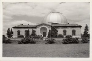
One-half mile east is the site of the former BIG EAR radio telescope. Designed by Dr. John D. Kraus, pioneering radio astronomer at Ohio State University, it had a collecting area of 340 by 70 feet (104 by 21 meters). The observatory was completed in 1963. The Ohio Sky Survey recorded here between 1965 and 1972 was the most accurate, reliable, and complete mapping of cosmic radio signals (the “radio sky”) for many years. BIG EAR gained fame for its ability to detect quasi-stellar radio sources, or “quasars,” and for its discovery of some of the most distant objects known. This observatory conducted a 24-year continuous search for evidence of extraterrestrial intelligence, during which the famous “Wow!” signal was received in 1977. BIG EAR was demolished in 1998. [“Wow!” signal graphic]
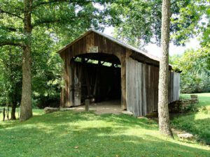
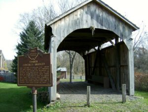
This covered bridge, spanning Salt Creek in Perry Township, Muskingum County was erected in the 1870s. It is a splendid example of an Ohio covered bridge built with Warren type trusses. It is being preserved as an important illustration of the sound, fine craftsmanship of the early bridge builders of Ohio. This plaque has been erected to give these men the honor they greatly deserve.
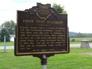
Brigadier General Albert G. Jenkins of Virginia, with 350 Confederate cavalrymen, crossed the Ohio River near this point on September 3, 1862, and advanced to Racine. After occupying the town for a few hours and after seizing a dozen horses, the troops re-crossed the river at Wolf’s Bar. This was the first invasion of Ohio soil by Confederate troops during the Civil War.
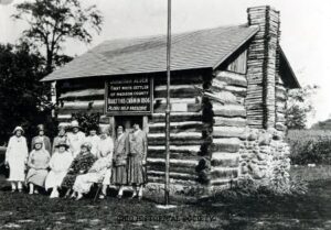
Seven-year-old Jonathan Alder was captured by a Native American war party in Virginia in 1782 and taken to a Mingo village north of the Mad River in Ohio where he was adopted by an Indian family. He remained with the Indians until after the 1795 Treaty of Greenville ended the Indian Wars in the Ohio Country. As white settlers entered the region, Alder frequently served as an interpreter. In 1805, he journeyed to Virginia and was reunited with his original family. He returned to Ohio with his new wife, Mary Blont, and built a cabin on Big Darby Creek. His cabin is now at the Madison County Historical Society Museum in London. Alder is buried in Foster Chapel Cemetery.
This covered bridge, over Middle Run, Elkrun Township, Columbiana County, is the shortest covered bridge in the United States still standing on a once-used public highway, having a clear span of 19 feet and 3 inches. It is an example, rarely found covered, of the simplest, most basic truss design, the two-panel king post truss. It has withstood the rigors of time and traffic since the 1870s and stands in eloquent testimony of the fine craftsmanship of the early Ohio bridge builders.
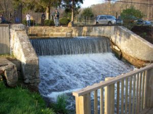
Sounds of boat horns and brawling packet crews resounded for many years at this lock and 142 others on the Ohio and Erie Canal. The canal was a 308-mile water toll road built between 1825 and 1832 from Lake Erie at Cleveland to the Ohio River at Portsmouth. The early growth of Akron and Massillon was due to the canal. Railroads caused its decline and the flood of 1913 destroyed its usefulness.
One of 69 charcoal iron furnaces in the famous Hanging Rock Iron Region. Extending more than 100 miles, from Logan, Ohio, to Mt. Savage, Kentucky, this area contained all materials necessary to produce high grade iron. The industry flourished for over fifty years in the mid-nineteenth century, during which time the area was one of the leading iron producing centers of the world. The charcoal iron industry was an important factor in the development of southern Ohio, and the romance of the Hanging Rock Iron Region forms a brilliant chapter in the industrial history of the Buckeye State.