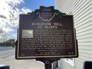
Established in 1823, the pioneer settlement of St. Marys became a thriving 19th century milling center following completion of the Miami & Erie Canal in 1845. The Reservoir Mill, built by Scott, Linzee & Co. in 1847, led this period of industrial growth as the first mill in St. Marys powered by the canal’s water. Robert B. Gordon purchased it in 1855 and in 1896 the mill passed to his son, Robert B. Gordon Jr., who formed the firm Gordon, Hauss & Folk. Producing “Purity” and “Pride of St. Marys” flour, Gordon, Hauss & Folk owned the mill until 1955. The mill was used as a grain elevator until 1972, then as a storage facility for the next 40 years. (Continued on other side)
Great Miami River Recreational Trail, Taylorsville Metro Park, 2005 U.S. Route 40
Vandalia
, OH
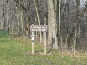
The Village of Tadmor is significant as being the location of one of the most important centers of transportation in early Ohio history. As early as 1809, keelboats were poled up river from Dayton to load and unload freight in the village. By 1837, the Miami and Erie Canal had reached Tadmor, connecting it to the Ohio River in the south and Lake Erie in the north. In the 1830s, the National Road was constructed through Tadmor, connecting it to points east and west. In 1851, the Dayton & Michigan Railroad established freight and passenger service to the growing town. Residents hoped that Tadmor’s strategic location would help it prosper, however, successive flooding on the Great Miami River stifled growth. Tadmor was finally abandoned when a dam constructed by the Miami Conservancy District in 1922 to retain water during flooding made the site uninhabitable.
Unsatisfied by the terms of the treaty that ended the French and Indian War, Ottawa chief Pontiac led a confederacy of Native American tribes in attacks against British frontier forts during 1763, a campaign known as “Pontiac’s Conspiracy.” In October 1764, Colonel Henry Bouquet led a 1500-man army into the Ohio country from Fort Pitt (present-day Pittsburgh) as a demonstration of British force and to free captives held by several tribes. Informed of possible attack, Bouquet diverted his army overland from his Tuscarawas River valley route and here deployed his forces into three lines: a group of scouts on each ridge and the main force along present Route 93. Evidence of artillery emplacements and infantry breastworks remained visible for many years.
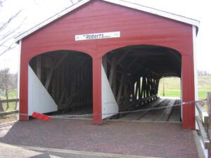
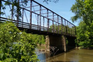
This covered bridge in the oldest still (1962) standing in the state and the last of the “double-barreled” spans in Ohio. It was built across Seven Mile Creek on the Old Camden Road in 1829-30 by Orlistus Roberts and J.L. Campbell. Its three burr-arch trusses built of native oak and poplar with a clear span of 73 feet, support the double roadway. This plaque has been erected to give due honor to the early timber covered bridge builders of Ohio and the important spans they constructed. [This side also contains a bridge illustration in the upper left corner]
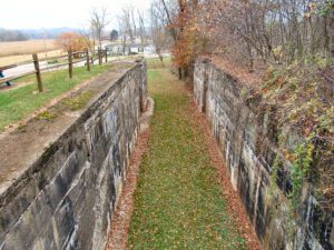
The Upper Trenton Lock (Lock 15 South) of the Ohio & Erie Canal was built between 1828 and 1829. Originally built of cut sandstone blocks, the lock was named for the Village of Trenton, now Tuscarawas. Lock 16, or Lower Trenton Lock, lies only 800 feet southwest of Lock 15. The lock tender, who lived in a house on this site, served both locks. Repeated flood damage prompted reconstruction of Lock 15 in 1907. The deteriorated stonemasonry was completely replaced with concrete at a cost of $6,815. The old stone was used to shore up the towpath. Use of the state-owned canal had declined significantly by this point, and the great flood of 1913 brought the canal era to an end in Ohio.
Using a four-mile long dam, the state of Ohio impounded the Licking Summit Reservoir in the mid-1820s to supply water for the Ohio and Erie Canal. In 1894, the state renamed it Buckeye Lake and developed it for recreational use. The Columbus, Buckeye Lake, and Newark Traction Company developed an “electric park” here, bringing in excursionists on interurban cars between 1904 and 1929 and creating one of the region’s most popular resorts. Hotels and summer cottages proliferated on leased ground. Nine acres in size, the park featured daily free admission during the summer. (continued on other side)
Now ranked among the country’s finest, the zoo began in 1900 with one large woodchuck in a box at Walbridge Park. After the organization of the Toledo Zoological Society, 1905-10, the zoo began its steady growth, particularly after 1923 under the leadership of Percy C. Jones. An ambitious federal construction program during the Great Depression of the 1930s provided several major structures.
Construction of the Ohio and Erie Canal, beginning in Cleveland and running south to Portsmouth, began in 1825. As a means to pay for debts on the community’s 5,500 acres of Tuscarawas County land, members of the Society of Separatists of Zoar contracted to construct this portion of the canal. They received $21,000 for this work, which was completed in 1827. Surplus goods were transported on Society owned and operated canal boats to outside markets via the Ohio and Erie Canal, which also brought manufactured items into Zoar. (continued on other side)