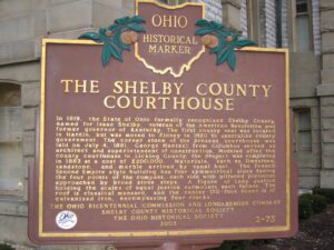
In 1819, the State of Ohio formally recognized Shelby County, named for Isaac Shelby, veteran of the American Revolution and former governor of Kentucky. The first county seat was located in Hardin, but was moved to Sidney in 1820 to centralize county government. The corner stone of the present courthouse was laid on July 4, 1881. George Maetzel from Columbus served as architect and superintendent of construction. Modeled after the county courthouse in Licking County, the project was completed in 1883 at a cost of $200,000. Materials, such as limestone, sandstone, and marble arrived by canal boat. The French Second Empire style building has four symmetrical sides facing the four points of the compass, each side with pillared porticoes approached by broad stone steps. A figure of Lady Justice holding the scales of equal justice surmounts each facade. The roof is classical mansard, and the center170-foot tower is of galvanized iron, encompassing four clocks.
The Northwest Ordinance of 1787 defined the boundary of the northern and southern tier of states to be carved out of the Northwest Territory, as a line drawn east from the southernmost tip of Lake Michigan until it intersects Lake Erie. Controversy over the exact location of that line led to the 1834-1837 boundary dispute between the State of Ohio and Michigan Territory. Passions ran high as everyone on both sides of the boundary knew that a great port city (Toledo) would emerge in the disputed territory. President Andrew Jackson settled the dispute in 1836 when he signed an act that recognized the current border between Ohio and Michigan, giving Michigan 9,000 square miles of Upper Peninsula land and awarding the disputed strip of approximately 470 square miles to Ohio. Michigan then joined the nation as a state the following year.
The founder of Ravenna Township in 1799, Benjamin Tappan Jr. led a distinguished life of public service. An aggressive force in local politics, he served in the Ohio Senate from 1803 to 1805, as judge of the fifth circuit court of common pleas from 1816 to 1823, and as federal district judge from 1826 to 1833. Tappan served as aide-de-camp to Major General Elijah Wadsworth following the surrender of Detroit in the War of 1812, provisioning and arming local militia units defending the northwestern frontier against a possible British invasion. (continued on other side)
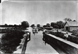
Digging of the Ohio-Erie Canal began in 1825, and the first canal boat navigated the Deep Cut at Licking Summit in 1831. The surrounding swamps were drained to create the Licking Reservoir, today known as Buckeye Lake, in order to supply adequate water for the canal going north to Coshocton and south to Circleville. After the canal route was established, the state engineers discovered that there was a ridge of hills located south of the proposed reservoir through which they would have to cut the canal. Since it was impossible to raise the level of the reservoir, the ridge had to be cut down to the level of the reservoir. This “Deep Cut” marks the deepest part of the canal at 32 feet and runs south from Millersport for nearly two miles. Unskilled laborers, primarily Irish immigrants, tirelessly dug the canal using picks, shovels, wheelbarrows, and oxen-cart.
The completion of the Wabash and Erie Canal on July 4, 1843 brought many new settlers into this region. The Wabash and Erie Canal connected with the Miami and Erie Canal at Junction. Antwerp, ideally located on the Maumee River, was seen as a perfect place in which to establish a town. That same year surveyors W. Wilshire Riley and Samuel Rice platted what would become Antwerp. Naming rights belonged to Riley and storeowner Horatio N. Curtis, who wanting a name not duplicated anywhere else in the country, named it after Antwerp, Belgium. Early pioneers subdued the massive forests that once formed the “Black Swamp” and built a thriving city. Antwerp was incorporated in 1863. (continued on other side)
Southeast of this point are the Big and Little tunnels. They were links in the 73-mile Sandy and Beaver Canal which connected the Ohio River with the Ohio and Erie Canal. Shifts of Irish laborers worked night and day with hand drills and blasting powder to cut the 1,060-yard Big Tunnel which opened for commercial use in 1850 and was abandoned two years later, a victim of the railroad.
After American militia troops forcibly ended the 1812 siege of Fort Wayne, General James Winchester’s Army of the Northwest marched down the north side of the Miami [Maumee] River to stop or retard advancing British troops sent to aid in the siege of Fort Wayne. After three days of difficult march, Ensign James Liggett of the 17th Regiment, volunteered to lead a group of four spies or scouts to the site of the old Fort Defiance. Liggett’s small force was surprised and killed on or about September 25 near here. The Americans tried twice to recover the bodies, but met with ambush from hostile Native Americans sympathetic to the British. Their bodies were finally recovered and buried in a common grave. Besides Liggett, they included Wyatt Stepp, Guy Hinton, William Bevis, and Nathaniel Mitchell of Woodford County, Kentucky, all of Captain McCracken’s Company, 1st Rifle Regiment, Kentucky Volunteer Militia.
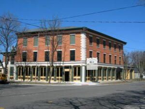
Levi Beebe built in 1836 this structure then known as the Commercial Building housing stores, bank, and post office. During the canal era, the building was a stagecoach stop and social center for Maumee, the Lucas County seat until 1853. Later the inn was called the Neely House, Schiely House, the Bismark, Seurin Hotel Langley Inn, and, after 1940, The Old Plantation.