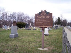
Isaac Scales (1786-1821) settled on this site. At his death, he was buried in his back yard. A large rock marked his grave. The land was reclaimed by Charles Olmsted who deeded it to the Township in 1835 for a public burial ground. Early settlers and veterans, who fought in six American wars including the Revolutionary, are buried here. The crypt was built in 1879.
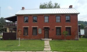
745 Davids Drive (is across the street from Greenway sign and pull-in)
Wilmington
, OH
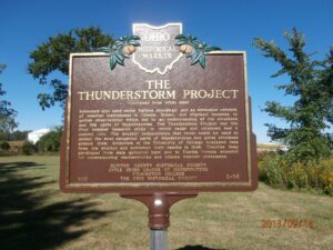
Before and during World War II, the aviation industry was vulnerable to adverse weather conditions, particularly thunderstorms. In 1945, Congress mandated the nation’s first large-scale, scientific study of thunderstorms. The Thunderstorm Project was a cooperative undertaking of the U.S. Weather Bureau, Army Air Force, Navy, and the National Advisory Committee for Aeronautics (predecessor of NASA). The first phase of the project was conducted in Florida in 1946 and the second phase in Clinton County in 1947, partly because weather fronts frequently pass through this area. Pilots from the Clinton County Army Air Force Base made many flights through storms of varying intensities and all stages of development. (Continued on other side)
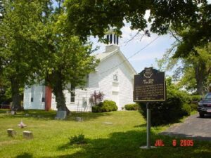
The Mount Zion Chapel of the Christian Church was built in 1872 on this hill adjacent to the members’ cemetery outside of Clermontville. The site was part of a two-acre parcel that had been secured from the farm of William R. Clark, Sr. for church and cemetery purposes. The Mount Zion Chapel replaced the Boat Run Christian Church that was organized in 1842 by a sect called the Christians, or the New Lights. Their first meeting house in Clermontville was dedicated on June 4, 1843 and damaged by floods in 1871. Worship was first held in the new frame church with the new name on October 6, 1872 and the church remains active today.
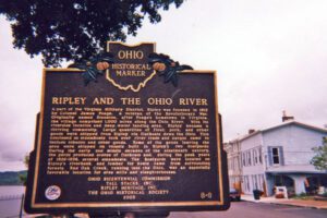
A part of the Virginia Military District, Ripley was founded in 1812 by Colonel James Poage, a veteran of the Revolutionary War. Originally named Staunton, after Poage’s hometown in Virginia, the village comprised 1,000 acres along the Ohio River. With its riverside location and deep water landing area, Ripley became a thriving community. Large quantities of flour, pork, and other goods were shipped from Ripley via flatboats down the Ohio. This continued as steamboats took over river trade and cargos came to include tobacco and other goods. Some of the goods leaving the area were shipped on vessels built in Ripley’s two boatyards. During the early and middle decades of the nineteenth century, the yards produced scores of flatboats and, during the peak years of 1826-1836, several steamboats. The boatyards were located on Ripley’s riverbank and lumber for boats came from surrounding forests. Red Oak Creek, running into the Ohio, was an especially favorable location for area mills and slaughterhouses.
Named for General Zebulon Pike, killed in the War of 1812, Pike County was organized in February 1815. Commissioners were charged with establishing a county seat and on May 12, 1815 accepted a conveyance of 40 acres from Elisha Fitch. The new seat was named “Piketon.” In 1816, the commissioners let a contract for the construction of a courthouse and jail. A fine two story courthouse with brick laid in Flemish bond was finished in 1819. A fire destroyed some country courthouse offices on October 9, 1844. The repaired courthouse was the seat of county government until 1861 and is part of the Piketon Historic District, which was listed on the National Register of Historic Places in 1974. Limestone headers above the windows have the names of the county government offices.
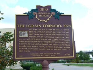
Just after 5:00 P.M on June 28, 1924, a tornado swept off Lake Erie directly into downtown Lorain. Within five minutes, seventy-eight people lost their lives. Fifteen died in the old State Theatre that stood upon this site, as an audience of two hundred watched a Saturday afternoon musical performance. More than one thousand suffered injuries. The tornado did extensive damage to the business district, destroyed 500 homes, and damaged a thousand more. The city’s largest industry, the American Shipbuilding yards, was severely damaged. The tornado, which had hit Sandusky before striking Lorain, continued along the shoreline and struck Sheffield and Avon minutes later. Contemporary accounts listed eighty-two deaths resulting from the deadliest tornado in Ohio’s history.
The Wyandot called the Grand Reserve home nearly a century before Ohio statehood. They built houses, cultivated the land, and grew bountiful groves of fruit trees. They governed from the nearby Wyandot Council House and operated a productive saw and grist mill. Many sent their children to school and worshiped at the limestone church, built in 1824, and recognized as the first Methodist mission in the country. But Ohioans set their sights on Wyandot lands in the fertile Sandusky River Valley. State and federal governments were unwilling to allow the Wyandot to remain on their chosen homelands, despite their participation in American society and friendly relations with neighboring settlers. Following the Indian Removal Act of 1830, the Wyandot were the last tribe removed from the State of Ohio in 1843.
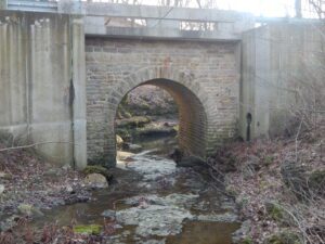
Listed on the National Register of Historic Places in 2009, the span is the oldest in Clark County a traveler can cross. It is also one of the oldest stone bridges in use in Ohio. Stone mason Samuel S. Taylor (1837-1930) built the culvert from locally quarried limestone in 1871, his first public works project. A Civil War veteran, Taylor worked on several projects, including the Mill Run underground sewer (1877), Champion’s East Street shops (1883), and the foundation for Springfield’s city hall (1890).