Its location and the tides of war established Gallipolis, then a town of some 3,000, as a point of strategic military importance to the Union upon the outbreak of the conflict in 1861. It was destined during the next four years to play a role without counterpart in Ohio. Here through this troop concentration area passed thousands of soldiers to the great campaigns. Here the traditional peacetime activity of the town, long a depot of supplies for the Kanawha Valley, was turned to military purposes for maintaining armies in the field. Here riverside warehouses held vast military stores to be transported by steamboat. Here newly-mustered troops set up Camp Carrington in a wheat field on the upper side of town. Here the women of Gallipolis helped minister to thousands of wounded and sick in an army hospital
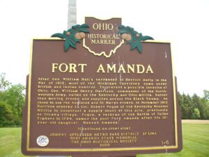
Fort Amanda State Memorial, OH 198, 1/4 mile S of Ft. Amanda Road, Lima
Lima
, OH
After Gen. William Hull’s surrender at Detroit early in the War of 1812, most of the Michigan Territory came under British and Indian control. To prevent a possible invasion of Ohio, Gen. William Henry Harrison, commander of the Northwestern Army, called up the Kentucky and Ohio militia. Rather than moving troops and supplies across the Black Swamp, he chose to use the Auglaize and St. Marys rivers. In November 1812 Harrison ordered Lt. Col. Robert Pogue of the Kentucky Mounted Militia to construct a supply depot at this site, previously an Ottawa village. Pogue, a veteran of the Battle of Fallen Timbers in 1794, named the post Fort Amanda after his 12-year-old daughter, Hannah Amanda. (continued on other side)
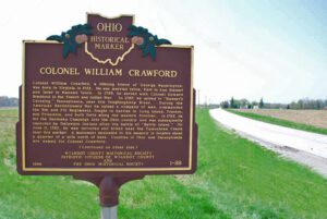
Colonel William Crawford, a lifelong friend of George Washington, was born in Virginia in 1722. He was married twice, first to Ann Stewart and later to Hannah Vance. In 1755, he served with Colonel Edward Braddock in the French and Indian war. In 1767, he moved to “Stewart’s Crossing,” Pennsylvania, near the Youghiogheny River. During the Revolutionary War he raised a company of men, commanded the 5th and 7th Regiments, fought in battles in Long Island, Trenton, and Princeton, and built forts along the western frontier. In 1782, he led the Sandusky Campaign into the Ohio country and was subsequently captured by Delaware Indians after the battle of “Battle Island.” On June 11, 1782, he was tortured and killed near the Tymochtee Creek near this marker. A monument dedicated to his memory is located about a quarter mile north of here. Counties in Ohio and Pennsylvania are named for Colonel Crawford.
You are standing on the famous portage, carrying-place between the Cuyahoga and Tuscarawas rivers. The two streams and the portage across the watershed formed an early route between Lake Erie and the Ohio River. First the Indians, then French and English traders and trappers, and finally American settlers and travelers carried their canoes and packs across this narrow strip of land in passing, by way of the rivers, between northern and southern Ohio. The portage was a part of the defined boundaries in the treaties with the Indians made at Fort McIntosh (1785), Fort Harmar (1789), and Green Ville (1795). Use of the portage was discontinued in 1827 when the Ohio and Erie Canal was built along the old trail. Today, modern Akron streets–Portage Path and Manchester Road–follow the approximate route of the original portage.
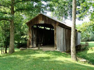
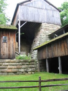
This covered bridge, spanning Salt Creek in Perry Township, Muskingum County was erected in the 1870s. It is a splendid example of an Ohio covered bridge built with Warren type trusses. It is being preserved as an important illustration of the sound, fine craftsmanship of the early bridge builders of Ohio. This plaque has been erected to give these men the honor they greatly deserve.
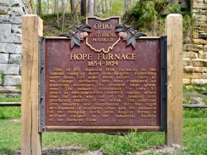
One of the 69 charcoal iron furnaces in the famous Hanging Rock Iron Region. Extending more than 100 miles from Logan, Ohio to Mt. Savage, Kentucky this area contained all materials necessary to produce high grade iron. The industry flourished for over 50 years in mid-nineteenth century during which time the area was one of the leading iron producing centers of the world. The charcoal iron industry was responsible for the rapid development of southern Ohio and the romance of the Hanging Rock Iron Region forms a brilliant chapter in the industrial history of the Buckeye State.
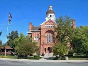
Named for John Paulding, a Revolutionary War soldier whose capture of a British spy implicated Benedict Arnold in treason, Paulding County was formed in 1820 from the last remaining unorganized area of Ohio. Sparsely settled, it remained under the jurisdiction of Wood County until 1824 and then Williams County until 1839. Paulding’s first county seat was established at New Rochester in 1839, then moved to Charloe in 1841. Neither village exists today. Centrally-located Paulding Center became the county seat in 1851, and a courthouse was built the following year. The present courthouse, built during the region’s timber boom of the late 19th century, was designed by architect Edward Oscar Fallis and patterned after his Lenawee County courthouse in Adrian, Michigan. The four-faced Romanesque style building was completed in 1888 at a cost of $40,000. It was listed on the National Register of Historic Places in 1974.
One of 69 charcoal iron furnaces in the famous Hanging Rock Iron Region. Extending more than 100 miles, from Logan, Ohio, to Mt. Savage, Kentucky, this area contained all materials necessary to produce high grade iron. The industry flourished for over fifty years in the mid-nineteenth century, during which time the area was one of the leading iron producing centers of the world. The charcoal iron industry was an important factor in the development of southern Ohio, and the romance of the Hanging Rock Iron Region forms a brilliant chapter in the industrial history of the Buckeye State.