On this site, the Miami and Erie Canal, that came north from Cincinnati and the Ohio River, intersected with the Wabash and Erie Canal that came from Fort Wayne and Evansville, Indiana. From this point, which became the town of Junction, the canals proceeded as one to Defiance, Toledo, and Lake Erie. From the 1830s to the 1870s, the canals played a key role in the settling of Paulding County, an area that was once a part of the Great Black Swamp. They held the promise of easier and quicker passenger transportation and commodity shipping and Junction became a landmark for fugitive slaves escaping to Canada. Once a thriving and growing community, the village of Junction became a forgotten historical note with the passing of the canal era and the coming of the railroads. Today, the Buckeye Trail and North County Trail follow the canal path through Paulding County.
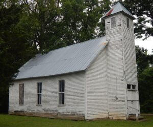
The present structure for the Macedonia Missionary Baptist Church was built in 1849 on Macedonia Ridge north of Burlington, an abolitionist sanctuary for escaped and freed slaves since 1799. It was built by the existing Baptist congregation and a group of 37 freed slaves who had arrived in Burlington from Virginia. The Baptist congregation in Macedonia had organized in 1811-1813 and practiced their faith in their homes and later in a small building with a bell tower made of sticks. The 1849 church was the religious and social focal point for the black community and became the “Mother Church” for approximately eight Baptist churches that exist in Ohio and West Virginia. The Macedonia Missionary Baptist Church was listed on the National Register of Historic Places in 1978.
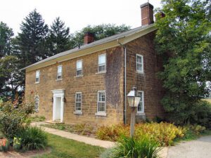
Frederick Rice was born on September 29, 1753, near Bethlehem, Northampton County, Pennsylvania and moved to Westmoreland County, Pennsylvania around 1766. During the American Revolution he served under George Washington at Valley Forge and fought in the Battle of Trenton on December 26, 1776, in which American forces surprised and captured 1,000 Hessian mercenaries. He served for two more years as a spy working against Native American tribes in western Pennsylvania. After his service he married Catherine Lauffer, and they raised eleven children to adulthood. Rice chose this 320-acre site, transferred to him in a deed signed by President James Monroe on May 21, 1821, because it offered excellent springs. He assigned the west half to son Simon and the east half to son Barnhart in 1822. Ownership remained in the Rice family until acquired for the Ohio Agricultural Experiment Station in 1891, renamed the Ohio Agricultural Research and Development Center in 1965.
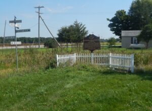
After the War of 1812, the United States Congress proposed two million acres of military bounty land for the Michigan Territory. To survey the land, the meridian had to first be established. U.S. Surveyor General Edward Tiffin created the meridian based on the western line of the Treaty of Detroit (1807). He contracted with Deputy Surveyor Benjamin Hough in April 1815 to begin the survey for $3 per mile. Taking a reading from Polaris (the North Star), Hough, Alexander Holmes, and 11 crew members surveyed the line due north from Fort Defiance. The difficult terrain they encountered temporarily halted all surveys in the territory and ultimately led to the bounty land being transferred to the Illinois and Missouri Territories.
Heritage Farm is a typical mid-19th century farm of the Ohio Western Reserve and has been restored and preserved. The original parcel of land consisted of 325 acres, which was purchased by David Berdan in 1818. The farmstead has been home to Abram and Sarah Berdan, William and Rachel Pitkin, George and Julia Tibbitts, and Peter and Mary Groening. The Heritage Farm Museum site consists of 4 acres with a house, privy, carriage house, corncrib, granary, equipment shed, barn, milk house, and chicken house, and was open to the public on July 1, 2000.
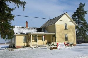
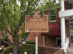
Creator of some of America’s favorite cartoon characters, Milton Caniff was born in Hillsboro in 1907 and graduated from Ohio State University in 1930. He created his first comic strip in 1932 for the Associated Press Syndicate, and in 1934 introduced “Terry and the Pirates,” an innovative serial adventure featuring believable characters drawn with unprecedented realism. Enormously popular through the World War II years for both “Terry” and the comic strip “Male Call,” which he created for the U.S. military’s Camp Newspaper Service, Caniff subsequently introduced “Steve Canyon” in 1947. “Steve Canyon” ran for forty-one years until Caniff’s death in 1988. Credited with influencing generations of successful cartoonists, Caniff brought adventure, suspense, and sensuality to what had been largely a medium for humor and melodrama.
Main Street, across from the Deersville United Methodist Church
Deersville
, OH
Mary Leonore Jobe was born on January 29, 1878, near Tappan, Harrison County, Ohio. She earned a bachelor’s degree from Scio College and master’s degree from Columbia University. While studying, she began a life-long career of exploration and natural history investigation. She first explored areas of British Columbia, Canada in 1905 and in 1916 started Camp Mystic, a summer camp in Connecticut for girls. She married explorer Carl E. Akeley in 1924 and completed an expedition to Africa when Carl died in the Belgian Congo in 1926. Honors include the naming of Mount Jobe in Canada to recognize her achievements and Belgium awarding her the Cross of the Knight, Order of the Crown, for her work in the Belgian Congo. She is known for her books and contributions to the American Museum of Natural History in New York. She died on July 19, 1966, and is buried in Deersville.
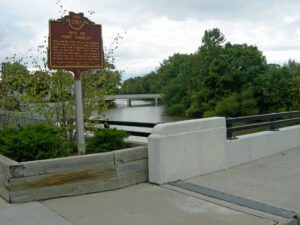
Early in the War of 1812, Gen. Wm. Hull, commander of Ohio troops, ordered Col. James Findlay to open a road from Ft. McArthur on the Scioto River to Blanchard’s Fork. Under Findlay, a stockade 50 yards square, with a blockhouse at each corner, was erected here and named in his honor. The fort was used as a supply depot.