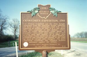
Col. William Crawford’s army of 480 Pennsylvania volunteers passed near this site on June 3 to attack the Indians near Upper Sandusky. On June 4-5 they encountered a combined force of Shawnees, Delawares, Wyandots, and, unexpectedly, Butler’s Rangers, a British unit from Detroit. The expedition was a disaster; about 300 Americans escaped. On June 6, about six miles west of this marker, the opposing forces met again at the “Battle of Olentangy.” With minor losses, the Americans continued their retreat, reaching the Ohio River on June 13. Crawford was captured, and burned at the stake on June 11.
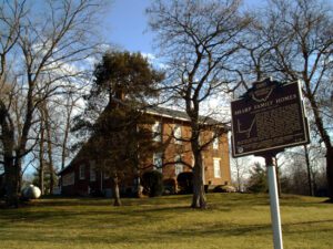
The Sharp family homes and their locations on N. State Street and Africa Road mark an important route through Westerville on the Underground Railroad. The family patriarch, Garrit Sharp, was an original settler of Sharp’s Settlement, now Westerville, and donated land for and helped organize the first Methodist church. He is also associated with the founding of Blendon Young Men’s Seminary, which was acquired by Otterbein College, an institution with enrollment open to African Americans and women from its inception in 1847. He and his sons were all noted abolitionists who, along with Bishop William Hanby and Otterbein president Lewis Davis, assisted southern slaves on their road to freedom. From the Sharp homes, slaves would have proceeded north to the house of Samuel Patterson on Africa Road and along Alum Creek to the Quaker settlement near Marengo in Morrow County.
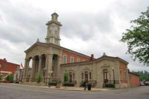
Ross County’s first courthouse was Ohio’s first statehouse. The courthouse was erected on the Public Square in 1801. Thomas Worthington, one of the building’s superintendents, laid out the foundation. Chillicothe was the last capital of the Northwest Territory, and the final session of the territorial legislature met in the courthouse in 1801. Ohio’s first constitution was written here in 1802. On March 1, 1803, Ohio’s first General Assembly convened in the building, making it the statehouse. During a time of strained relations between Native Americans and settlers in Ohio, the great Shawnee leader Tecumseh delivered a speech here in 1807 to reassure citizens that the Indians would remain peaceful. The courthouse served as the statehouse from 1803 to 1810 and from 1812 to 1816. The building was razed in 1852 to make way for the present courthouse.
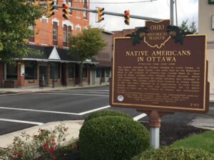
The Ottawa, or “Tawa” Indians had inhabited the Maumee Valley since the middle of the 1700s. By the 1790s, Ottawa settlements included villages along the Blanchard River at the present-day Village of Ottawa. During the War of 1812, Colonel James Findlay destroyed these villages because the Ottawa aided British forces. In 1817, the United States government established a reserve for the Ottawa in exchange for their lands in Northwest Ohio. The reserve encompassed a five-mile square area; its center was the intersection of the Blanchard River and an Indian trace near what is now Old State Route 65. (Continued on other side)
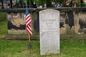
The Walnut Grove Cemetery is the burial place of members of the Zane and Martin families. Their graves lie within the brick enclosure. The cemetery is also the resting-place of many early Martins Ferry residents, including veterans of the Revolutionary War, the War of 1812, the Mexican War, and the Civil War. The Zane and Martin families were significant in the pioneer history of the region. Betty Zane’s legendary heroism at Fort Henry (now Wheeling, West Virginia) helped settlers resist an attack by the British and their Native American allies in September 1782. (Continued on other side)
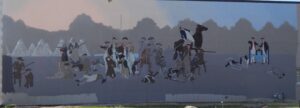
Native Americans inhabited and used much of the land in the Ohio valley as hunting grounds. As American settlers pushed west, conflicts resulted and attempts at peaceful settlement failed. Under political pressure, President George Washington resolved to subdue Indian resistance to American expansion in the Ohio country and appointed General Arthur St. Clair to lead the expedition. St. Clair’s troops camped on the Wabash River (just east of the Ohio-Indiana state line) after an exhausting two-month trek. The ill-prepared soldiers were no match for the forces of Miami, Shawnee, and Delaware Indians who attacked them at dawn of November 4, 1791. By the day’s end, warriors led by Little Turtle and Blue Jacket had killed or wounded nearly three-quarters of the American force-the worst-ever defeat of the U.S. Army by Native Americans in a single battle.
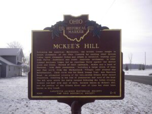
Following the American Revolution, the British Crown sought to retain possession of the Ohio Country by sending chief British Indian Agent Alexander McKee and others to establish trading posts with Native Americans and resist American settlement. In 1786, Colonel Benjamin Logan led an American force against the British posts and tribes. Warned of their approach, McKee and a band of Shawnee, took their possessions, including a large drove of hogs, and fled north from the Mackachack Villages near present-day Bellefontaine. Their route was the Black Swamp Trail, now Napoleon Road. An attempted crossing of the rain-swollen Ottawa River turned disastrous, resulting in the loss of possessions and most of the hogs. The hill upon which the party camped following the failed crossing, located one half mile east of here, became known as McKee’s Hill, and the portion of the Ottawa River east of Lima has since been known as Hog Creek.
With the signing of the Treaty of Paris in 1783, England lost the American Revolution and ceded to its former colonies land from the Atlantic Ocean to the Mississippi River. By this time, pioneer settlers had reached the eastern bank of the Ohio River, but the Ohio Country, located west and north of the river, was still considered Indian Territory. The Indian tribes desperately defended their hold on this land. On August 20, 1794, United States forces led by Major General Anthony Wayne defeated an Indian alliance at the Battle of Fallen Timbers fought near modern-day Toledo. One year later, on August 3, 1795, the largest assemblage of northwestern Indian representatives at a peace settlement signed the Treaty of Greene Ville, which effectively ceded all land south of the Greene Ville Treaty line to the Americans. The Fort Laurens site was a reference point in the Treaty line. The Ohio Country was then rapidly settled, and in 1808, Tuscarawas County was organized.