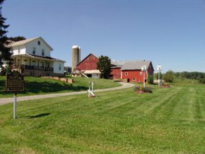
Jonas Stutzman, from Somerset County, Pennsylvania, came to this site in 1809 to clear land for farming and to build a log home for his family. He was the first permanent settler in the eastern portion of what would in 1825 become Holmes County. Jonas and his wife Magdalena Gerber Stutzman were of the Amish faith–descendants from a group of strict Protestant Anabaptists with origins in Switzerland and Holland and dating from the 16th -century Protestant Reformation. Some of their beliefs, including separation of church and state, refusal to take oaths, pacifism, and believer’s baptism, were perceived as threats to the state church and government. Persecuted by both Catholics and Protestants, Anabaptists migrated and some came to the New World, many at the invitation of Pennsylvania’s William Penn. The Stutzmans and other early Amish pioneer setters-Millers, Hershbergers, Hochstetlers, Weavers, Troyers, Masts, and Schrocks-founded here what has become the largest Amish settlement in North America.
Its location and the tides of war established Gallipolis, then a town of some 3,000, as a point of strategic military importance to the Union upon the outbreak of the conflict in 1861. It was destined during the next four years to play a role without counterpart in Ohio. Here through this troop concentration area passed thousands of soldiers to the great campaigns. Here the traditional peacetime activity of the town, long a depot of supplies for the Kanawha Valley, was turned to military purposes for maintaining armies in the field. Here riverside warehouses held vast military stores to be transported by steamboat. Here newly-mustered troops set up Camp Carrington in a wheat field on the upper side of town. Here the women of Gallipolis helped minister to thousands of wounded and sick in an army hospital
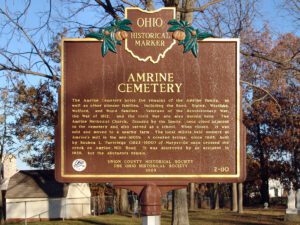
The first permanent settlement in the Marysville area, was founded in 1817 by Revolutionary War veteran Abraham Amrine (1761-1849) and his sons. The Amrines emigrated from Switzerland to Pennsylvania in the early 1700s and, after living in Belmont County, Ohio for 16 years, Abraham purchased 1000 acres here along Mill Creek circa 1817, paying $2 an acre. When Paris Township was organized in 1821, the township officers were elected in Amrine’s home on Newton Pike (now Raymond Road). All seven of his sons, John, Andrew, Moses, Frederick, Jeremiah, Abraham, Jr., and Henry, settled here. Andrew was a Justice of the Peace and leader in the church. Near this site, Henry built a sawmill in 1822 and a gristmill in 1825, which were operated by the family for more than 50 years.
Intersection of Mt. Vernon Avenue and LWR Gamiber Road.
Mount Vernon
, OH
Named for the Native Americans who first dwelled here along both sides of the Kokosing River, the Little Indian Fields is adjacent to the site of the first white settlement of Knox County. Early white inhabitants of this land were Andrew and Catherine Craig and Benjamin and John Butler. John “Appleseed” Chapman planted an apple orchard near here at the confluence of the Kokosing River and Centre Run and in 1809 bought two lots in Mount Vernon. In 1808 the Ohio Legislature created Knox County and later designated Mount Vernon as the county seat.
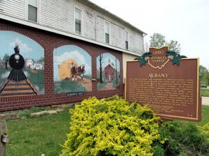
The village of Albany was established in 1838 as a market center for the surrounding agricultural area, which saw its first white settlement in the early years of the nineteenth century. Education was always a major concern of Albany’s citizens. Since public schooling was minimal, private academies provided the community various levels of education from the 1840s to the 1880s. Anti-slavery sentiment also was strong in Albany, and many of its citizens participated in the “Underground Railroad.” Because of educational opportunities and sympathetic white neighbors, free African-Americans came to Albany, but most had moved away by the 1930s. After World War Two, the village lost its status as a center for commerce and business.
In the 1820s a general store and grist mill were established on this site, where the famous Scioto-Sandusky Indian trail neared the Sandusky River. The settlement was first known as McNutt’s, later as Swope’s Corners. The village of Fort Seneca was surveyed January 14, 1836. Its name was derived from Gen. Harrison’s War of 1812 fort, which was located a few miles downstream.
In 1772-73 missionary David Jones visited Blue Jacket’s Town, a settlement of 12 cabins downstream on the east bank and Pickaweekee, a Shawnee town, on the west bank. Deercreek Methodist Circuit Deacon, Dr. Edward Tiffin, met settlers after 1798. Dr. Tiffin was later elected first governor of Ohio. A station of Virginia bounty-land settlers, “Williams Town,” assembled here around 1797. Mill sites, established before Pickaway County, flourished in the dense oak forest of Deercreek Township. Frontier hotels in Williamsport prospered due to the “healthful” sulphur springs.
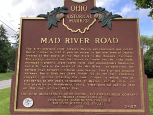
The first overland route between Dayton and Cincinnati was cut by Daniel Cooper in 1795 to provide access to the new town of Dayton, located at the mouth of the Mad River in the Symmes Purchase. The survey, entered into the record by Cooper and Dr. John Hole, extended Harmer’s Trace north from near Cunningham’s Station on the Mill Creek to the mouth of the Mad River, establishing the earliest road between Cincinnati and Dayton. This five-mile segment between David Road and State Route 725 is the last remaining traceable portion retaining this name. Cooper, a miller, was instrumental in the early settlement of Dayton, and Dr. Hole, the first physician in Montgomery County, established his cabin in 1796 on this part of Mad River Road.