The first overland route between Dayton and Cincinnati was cut by Daniel Cooper in 1795 to provide access to the new town of Dayton, located at the mouth of the Mad River in the Symmes Purchase. The survey, entered into the record by Cooper and Dr. John Hole, extended Harmer’s Trace north from near Cunningham’s Station on the Mill Creek to the mouth of the Mad River, establishing the earliest road between Cincinnati and Dayton. This five-mile segment between David Road and State Route 725 is the last remaining traceable portion retaining this name. Cooper, a miller, was instrumental in the early settlement of Dayton, and Dr. Hole, the first physician in Montgomery County, established his cabin in 1796 on this part of Mad River Road.
The landscape of northwest Ohio was formed by melting ice and the glacial lakes left behind in its wake. Because of the low gradient (3 feet fall per mile) to the northeast, the flat lacustrine plain evolved into a large swamp. A massive swamp forest with huge hardwoods, broken only sporadically with intermittent wet prairies and savannahs, dominated the landscape. Both prehistoric and historic Indians farmed the flood plains of the Maumee River and its tributaries: Auglaize, Tiffin, and Blanchard rivers. (continued on other side)
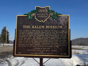
Here, on April 6, 1780 during the American Revolutionary War, a contingent of Delaware Christian Indians, led by John Heckwelder, an assistant to Moravian missionary David Zeisberger, founded the last of five missions to occupy the Tuscarawas Valley between May 3, 1772 and September 8, 1781. The mission was located immediately adjacent to the west bank of the Tuscarawas River. Eighteen months later, British led Indian soldiers forcibly removed to the Upper Sandusky region all 400 of the Indian converts then living in the Tuscarawas Valley at the New Schoenbrunn, Gnadenhutten, and Salem missions. Seventeen years later, Zeisberger returned to the Tuscarawas Valley and founded his last mission at Goshen on October 4, 1798.
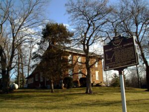
The Sharp family homes and their locations on N. State Street and Africa Road mark an important route through Westerville on the Underground Railroad. The family patriarch, Garrit Sharp, was an original settler of Sharp’s Settlement, now Westerville, and donated land for and helped organize the first Methodist church. He is also associated with the founding of Blendon Young Men’s Seminary, which was acquired by Otterbein College, an institution with enrollment open to African Americans and women from its inception in 1847. He and his sons were all noted abolitionists who, along with Bishop William Hanby and Otterbein president Lewis Davis, assisted southern slaves on their road to freedom. From the Sharp homes, slaves would have proceeded north to the house of Samuel Patterson on Africa Road and along Alum Creek to the Quaker settlement near Marengo in Morrow County.
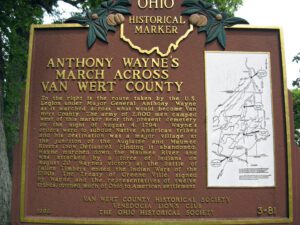
To the right is the route taken by the U.S. Legion under Major General Anthony Wayne as it marched across what would become Van Wert County. The army of 2,800 men camped west of this marker near the present cemetery on the night of August 4, 1794. Wayne’s orders were to subdue Native American tribes and his destination was a major village at the junction of the Auglaize and Maumee Rivers (now Defiance). Finding it abandoned, Wayne marched down the Maumee River and was attacked by a force of Indians on August 20. Wayne’s victory at the Battle of Fallen Timbers ended the Indian Wars of the 1790s. The Treaty of Greene Ville, signed by Wayne and the representatives of twelve tribes, opened much of Ohio to American settlement. Side one includes a map on the right hand side of the marker showing the route of Wayne’s army through the eastern third of Van Wert County.
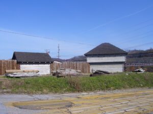
In 1787, the construction of Fort Steuben was completed by Captain John Francis Hamtramck and soldiers of the 1st American Regiment, who were sent to the frontier by the United States government to remove illegal squatters and protect government surveyors from American Indian raids. The surveyors were platting the First Seven Ranges of the Northwest Territory. The surveyed land was sold for settlement or offered to soldiers as payment for military service during the Revolutionary War. Consequently, the states of Ohio, Illinois, Indiana, Michigan, and Wisconsin were formed from the settlement of the Northwest Territory. Fort Steuben was named after Baron Frederich Wilhelm Augustus Steuben, who had served in the Revolutionary War and from which the town derived its name. Captain Hamtramck abandoned the fort in 1787 by order of Colonel Josiah Harmar, and by 1790 the remains of the fort had disappeared. Fort Steuben has been reconstructed on its original location.
Three-way intersection of David Brown Road, Mechanicsburg-Sanford Road, and Becker Road.
Mechanicsburg
, OH
The W. Pearl King Prairie Savanna is a mostly undisturbed remnant of the once expansive Darby Plains Prairies. Prior to European settlement more than two centuries ago, the Darby Plains covered an area of more than 380 square miles west of Columbus. These prairies were an eastward extension of the Great Plains Prairie that Ohio State Professor Edgar Transeau termed the Prairie Peninsula in 1935. The W. Pearl King Prairie Savanna is a 20-acre vestige of a once large and varied habitat of native tallgrass prairie and oak groves. The prairie contains bur oaks, one of Ohio’s largest stands of prairie dropseed grass, and several other native prairie plants. Named for a former landowner, William Pearl King (1891-1960), the site has been owned and managed by Columbus and Franklin County Metro Parks since 2006.
In 1798, Henry Massie, brother of General Nathaniel Massie, platted a town, the earliest permanent settlement in Highland County, covering 400 acres and named it New Market after a town in his native Virginia. New Market served as the unofficial county seat until Hillsboro assumed that title in 1807. Despite being traversed by the Cincinnati-Chillicothe Post Road with seven other roads (including one from Manchester) leading in, New Market ceased being an active trade and civic center. It is now a small hamlet with a cluster of dwellings, a church, and a few businesses.