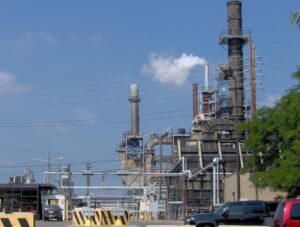
Oil became a valuable resource in Ohio when significant quantities were discovered in Lima in 1885. The discovery brought an economic boom to Lima and northwest Ohio. News of the Lima oil field spread, attracting the attention of John D. Rockefeller, co-founder of Standard Oil. Against the advice of his board, Rockefeller invested heavily in Lima crude, despite its high sulfur content and foul odor. Storage tanks and pipelines for the crude sprung up rapidly. Having great faith in the ingenuity of his engineers and scientists, Rockefeller stockpiled the crude and sent Standard’s chief refining specialist, J.W. Van Dyke, to Lima to construct and manage the new Solar Refinery. Together with Herman Frasch, a German chemist, the two men perfected the technique to desulphurize the crude and turn it into quality kerosene and fuel oil.
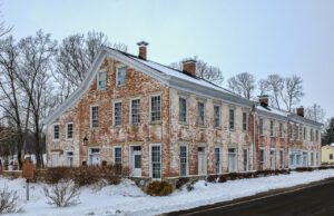
The Bunker Hill House, previously the Bunker Hill Tavern, was built in stages between 1834 and 1862. The building is one of Ohio’s best representations of Federal-Greek Revival style “pike town” architecture. This architectural style is closely associated with pre-Civil War horse-powered turnpike transportation and lodging. The building was a way station for pioneers heading west and for drovers driving their animals to Cincinnati stockyards. It was also a stagecoach stop on Eastern Stage Coach Company’s Cincinnati Omnibus Line that operated daily between Cincinnati and Richmond, Indiana. Tavern operations ceased in 1858 due to decreased turnpike travel resulting from the newly completed railroad through nearby Camden. In 1862, a general store was established to supply the growing population in the area. The store closed in the early 1900s with the advent of the automobile, which made travel to larger, more distant stores viable. The Bunker Hill House was listed on the National Register of Historic Places in 2001. (continued on other side)
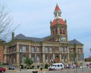
Established as the county seat of Pickaway County in 1810, Circleville derives its name from the circular portion of a large Hopewell-era earthwork upon which it was built. The Circleville earthworks, described in 1772 by Rev. David Jones for a Boston magazine, comprised an 1,100 foot diameter circle connected to a 900 foot square. Town director Daniel Dreisbach platted the town directly atop the earthworks, integrating the town plan into the prehistoric landscape. An octagonal courthouse stood directly in the center.
Main Street, across from the Deersville United Methodist Church
Deersville
, OH
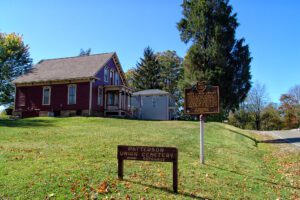
Mary Leonore Jobe was born on January 29, 1878, near Tappan, Harrison County, Ohio. She earned a bachelor’s degree from Scio College and master’s degree from Columbia University. While studying, she began a life-long career of exploration and natural history investigation. She first explored areas of British Columbia, Canada in 1905 and in 1916 started Camp Mystic, a summer camp in Connecticut for girls. She married explorer Carl E. Akeley in 1924 and completed an expedition to Africa when Carl died in the Belgian Congo in 1926. Honors include the naming of Mount Jobe in Canada to recognize her achievements and Belgium awarding her the Cross of the Knight, Order of the Crown, for her work in the Belgian Congo. She is known for her books and contributions to the American Museum of Natural History in New York. She died on July 19, 1966, and is buried in Deersville.
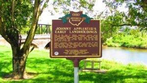
This is the site of Johnny Appleseed’s earliest known recorded landholdings. Appleseed (whose legal name was John Chapman) purchased two parcels from Joseph Walker on September 14, 1809: Mount Vernon town lot 147, upon which you stand, and lot 145, which is across the road and north of this site. Johnny Appleseed likely rested here on August 10, 1813, after arriving from Mansfield with alarming news of a rumored Indian attack. Appleseed returned to Mansfield with reinforcements from Mount Vernon that same day–a round trip of over fifty miles.
On the banks of the Olentangy River, at the bend where the stream turns southwest, is the legendary site of Seccaium. This 17th century village was located on the portage to the Sandusky River, and was recognized by the Indians as a neutral ground for tribal councils where claims to hunting territories could be peacefully settled and goods could be traded. In the early 20th century, the site was an amusement park on the interurban electric railway.
A migration of Indians throughout Ohio began due to unstable conditions created by the American Revolution. The massacre of Christian Indians at the Moravian mission of Gnadenhutten in 1782 and Colonel William Crawford’s expedition against Wyandot and Delaware towns along the Sandusky fueled insecurities. Delaware, including a small group of Mingo Indians, abandoned the village of Helltown, five miles southwest of this site, and settled Greentown as early as 1783. Greentown, situated on an elevation on the Black Fork beyond the clearing behind this site, was presumably named for British loyalist, Thomas Green. John Chapman (Johnny Appleseed) had an amicable relationship with the Delaware, owned land throughout the Black Fork Valley, and was known to visit Greentown on his travels throughout Ohio. Other visitors to the village included the Shawnee Prophet; Munsee Delaware leader, Captain Pipe; and local preacher, James Copus.
Early in the War of 1812, Gen. Wm. Hull, commander of Ohio troops, ordered Col. James Findlay to open a road from Ft. McArthur on the Scioto River to Blanchard’s Fork. Under Findlay, a stockade 50 yards square, with a blockhouse at each corner, was erected here and named in his honor. The fort was used as a supply depot.