

, OH
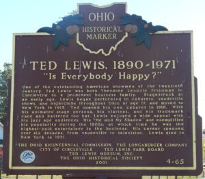
One of the outstanding American showmen of the twentieth century, Ted Lewis was born Theodore Leopold Friedman in Circleville to a prominent business family. Stagestruck at an early age, Lewis began performing in cabarets, vaudeville shows, and nightclubs throughout Ohio at age 17, and moved to New York in 1915. Ted opened his own cabaret in 1918. With his animated stage persona, his clarinet, and his trademark cane and battered top hat, Lewis enjoyed a wide appeal with his jazz age audiences. His “Me and My Shadow” act exemplified his popularity during the 1920s, at which time he was the highest-paid entertainer in the business. His career spanned over six decades, from vaudeville to television. Lewis died in New York in 1971.
, OH
Native Americans inhabited and used much of the land in the Ohio valley as hunting grounds. As American settlers pushed west, conflicts resulted and attempts at peaceful settlement failed. Under political pressure, President George Washington resolved to subdue Indian resistance to American expansion in the Ohio country and appointed General Arthur St. Clair to lead the expedition. St. Clair’s troops camped on the Wabash River (just east of the Ohio-Indiana state line) after an exhausting two-month trek. The ill-prepared soldiers were no match for the forces of Miami, Shawnee, and Delaware Indians who attacked them at dawn of November 4, 1791. By the day’s end, warriors led by Little Turtle and Blue Jacket had killed or wounded nearly three-quarters of the American force-the worst-ever defeat of the U.S. Army by Native Americans in a single battle.
, OH
This historic village was a hub for early Ohio industry and travel. The natural geography of the area provided ideal conditions for the establishment of a variety of mills. Col. Robert Patterson, an ancestor of the founder of National Cash Register in Dayton, John Patterson, chose Clifton for the site of a woolen mill, which furnished material for the American army during the War of 1812. Davis Mill, established in 1802 and in operation today as Clifton Mill, produced meal and flour for Civil War troops. A major stop on the stagecoach trail, “The Accommodation Line,” which ran from Springfield to Cincinnati from 1827 to 1840, the village bustled with the commotion of travelers. The once flourishing industry of Clifton faded as railroad traffic bypassed the village and manufacturers left the area.
, OH
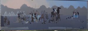
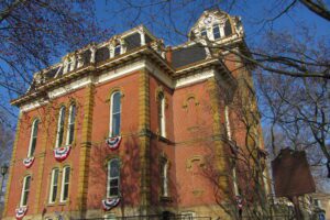
In 1764, Colonel Henry Bouquet established the site of what is now Coshocton. In 1811, the county was founded and the town incorporated as the county seat. The Coshocton County Courthouse, the third on this site, was built between 1873 and 1875 by contractors Carpenter and Williams of Meadville, Pennsylvania. The Second Empire structure features a five-story tower containing a four-faced clock and the bell from the previous 1824 courthouse. The courthouse contains a notable mural by artist Arthur William Woelfle depicting the signing of Bouquet’s treaty with the Indians near the Walhonding River in November 1764. The Coshocton County Courthouse was added to the National Register of Historic Places in 1973.
, OH
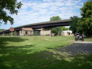
Lowell was the site of one of ten wooden covered bridges, built from 1820 to 1887, that crossed the Muskingum River from Marietta to Coshocton. The Lowell bridge was built in 1881. Bridges were built out of wood because there was plenty of lumber available, and building with wood was easier and cheaper than using stone. Covers protected the timbers from rain. The bridge connected Lowell, on the north side of the river, with the railroad that ran on the south side. This bridge suffered from many mishaps typical of wooden bridges. In 1882 a severe storm blew off the roof. In 1884 a flood washed the bridge off its stone piers. The bridge was restored, only to be destroyed by the 1913 flood, a disaster that removed many bridges on the river. An iron bridge was built on the site. The last covered bridge on the river was at Conesville seven miles south of Coshocton. Built in 1876, the bridge was condemned in 1958 and destroyed by a controlled fire.
, OH
Fostoria’s glass era began when natural gas was discovered in the mid 1880s at “Godsend,” five miles west of town. Aided by former governor Charles Foster, Fostoria attracted more than a dozen companies that manufactured utilitarian and decorative glassware from 1887 to 1920. These companies produced windows, bottles, tableware, lamps, shades, and electric incandescent lamps. The Fostoria Glass Company was the best-known manufacturer of glass in Fostoria. From 1887 to 1891, it made a wide variety of decorative glass including its famous “Victoria” pattern tableware. Even after the company relocated to Moundsville, West Virginia following the depletion of natural gas in the area, it retained the name “Fostoria, ” which is still synonymous with excellence in the glass-making art.
, OH
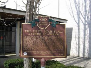
The design for the fifty star flag was born here at Lancaster High School in 1958 when student Robert Heft designed it for a history class project. Reasoning that since Alaska was seeking admission as a state and that Hawaii would soon follow, Heft constructed a fifty star flag from an old 48-star flag using blue cloth to replace the field and white adhesive for the stars. When Heft received a B- on his project, his teacher, Stanley Pratt, promised that he would raise the grade if he submitted the flag design to their congressman, Walter Moeller. Moeller in turn passed the flag design on to the chairman of the Congressional Flag Design Committee, who also liked it. President Dwight D. Eisenhower made the design the official American flag in 1960. It is the only flag in American history to have flown over the White House for more than five administrations.
, OH
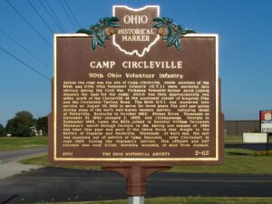
Across the road was the site of Camp Circleville, where members of the 90th and 114th Ohio Volunteer Infantry (O.V.I.) were mustered into service during the Civil War. Pickaway Township farmer Jacob Ludwig donated the land for the camp, which was then approximately two miles south of the Circleville at the southwest corner of Kingston Pike and the Circleville-Tarlton Road. The 90th O.V.I was mustered into service on August 29, 1862 to serve for three years. The unit saw action during some of the war’s well-known western battles, including those at Perryville, Kentucky in October 1862; Stones River, Tennesee on December 31, 1862-January 2, 1863, and Chickamauga, Georgia in September 1863. Later, the 90th joined in General William Tecumseh Sherman’s march through Georgia in the spring and summer of 1864 and later that year was part of the Union force that fought in the Battles of Franklin and Nashville, Tennesee. At war’s end, the unit was mustered out of service at Camp Dennison, near Cincinnati in June 1865. During the regiment’s service, five officers and 247 enlisted men were killed, mortally wounded, or died from disease.